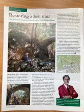
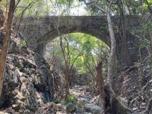
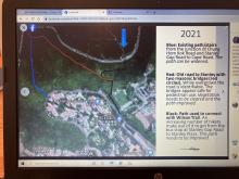
If you walk from Stanley Plaza up Carmel Road you will find a Parking Place on the right side. Walk into the parking place and turn right. At the far end there is a small fence, where you can squeeze trough. Not difficult. Then you can see a small "trail" which leads along the fence of a prison which stands next to it. The building of the prison has a pale blue color. There you walk up along the barb wires and at the end of the small hill you turn left. The small bridge will apear first. If you walk further along the trail then you will find the larger bridge. From there you can continue on the trail and eventually you will get out a section with many stairs. From there you can walk up to the junction of Stanley Gap Road and Chung Hom Kok Road. If you walk down the stairs then you will end up at Carmel Road again. I hope this will help. I will send a photo right away with a small map.


Comments
Re: Old path
Hi There,
https://www.map.gov.hk/gm/geo:22.2226,114.2079?z=2257
According to GeoInfo Map, that appeared to be an old path. However your entry point is very much in the vicinity of the prison, bourdering to traspassing in Government land. Might be an offence if the Correctional Service Department is thrown into the mix.
T
Many hikers make use of it to
Many hikers make use of it to get from the bus stop at Stanley Gap Road to Stanley Plaza. We were there last week and cleaned up part of the Old Stanley Road, between the bridges quite a bit, but more needs to be done to improve this path. Otherwise you can get into the woods from the other end by the long staircase.
Thank you T and best regards