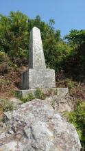
Two identical stones on the north and south shores of Lantau Island mark the points at which the sea boundary (Pre-1997) with China touches the Island. The stones are granite, pointed on top, and standing on stone bases. A carved inscription on one of the faces of each base states that the stones were fixed in position by Lieutenant-Commander F.M. Leake, R.N. and officers of H.M.S. Bramble in 1902 in the longitude 113°52'0". The opposite face bears a corresponding inscription in Chinese. Both stones are marked as obelisks on ordnance maps.
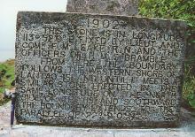
The text differs slightly on the two stones. The full text on the Southern Obelisk:
1902
This stone is in longitude
113°52'0" fixed by Lieut and
Comdr F.M. Leake, R.N. and the
officers of H.M.S. "Bramble".
From here the boundary
follows the western shore of
Lantao Island until it meets a
similar stone erected in the
same longitude on the north
side of the island southward.
The boundary extends to the
parallel of 22°9'0".
This stone is placed 200
feet above H.W. mark for the
purpose of protecting it from
possible inroads of the sea.
Source: In Search of the Past: A Guide to the Antiquities of Hong Kong and own notes. See Lantau North Obelisk here The obelisk marking the eastern longitude of Hong Kong can be read here
Photos that show this Place