Current condition
Ruin
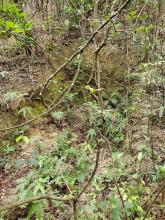
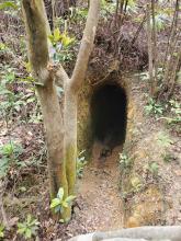
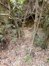
Just 20m West off Hong Pak Trail (A ribbon path will guide you) once can find an open and easy accessible Japanese Tunnel Entrance. To the left of this tunnel on the same side of the hill there's another 3 potential but now covered former tunnel entrances. Just follow the the relatively short concrete water conduit for about 60m.
Does anyone have any aerials from the area from WW2?
There's a myriad of small paths in the area, not all have ribbons or are on hiking/gov apps&maps.
Photos that show this Place
????
????
????
Comments
Hit today
Appreicate tagging the are MikeB. Saw the markers on maps but had'nt yet visited. Goes steep and deep into the hillside as some designs seem to do. Pretty deep down, about 20 meters or so. Quite spacious too. The honeycombed trails go up and over a hill north of Hong Pak trail, on the other side of which is the 'three split tunnel' marked nearby on the map. Both sides connected to Hong Pak.
Most welcome
Glad you found it. It would be good to see some old aerial photos of the hill. I wonder if the other tunnels nearby also were of similar length and layout, sadly all covered up by now.
Not sure if all of them were
Not sure if all of them were covered up, I do think that some were simply just cuttings. Like they started but decided to not go through with it. Or some cuts into big squares have had other uses I believe. Craig said many were small AA positions or it would seem some were outdoor storage areas.
Good point
So maybe just one tunnel after all and some cuttings. Guess we will never find out unless somebody starts digging away.