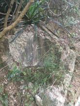
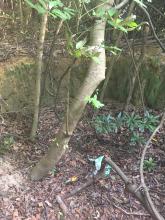
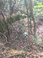
I was doing some extensive exploring today and just generally checking out some areas when I came upon a cool find. After wandering up some gutters to the top of the ridge above the first bend on Deep Water Dr. I came accross a couple distinct pits/embankments (which I strongly believe to be firing pits) , and the ruin of an unidentified structure.
The firing pits were quite large, dug in up to a 1/2 meter deep and facing north towards Mount Nicholson. and Wong Nai Chung Gap. They were on the ridge above Deep Water Bay Dr. and not far below Deep Water Bay Road by that point.
All the evidence I have makes it seem to me these were part of positions that engaged the Japanese on Mt. Nicholson.
From Not the Slightest Chance
Dec 22 --21.10--
The Japanese themselves (under Doi) recieve 9.2-inch fire from Stanley and 20,000 round of .303 from Little Hong Kong (95: 128). 'Our effort to hold Mt. Nicholson was harrassed by enemy gun fire from Red Hill Promontory and by machine gun fire from the area south of Mt. Nicholson (122).'
-I am not sure what the ruins were either. Its a very peculiar size, similar to a sentry box or a storage shelter, but possibly just a water tank or something of the sort


Comments
I dont have a GPS reading for
I dont have a GPS reading for this area, I stumbled accross it and only know the approximates. It is only 50 meters or so up the road from Crown Wine Cellars
David Manning
David Manning mentions (what seems like) these emplacements in the HKIS report.. They also appear in a similar area as his sketches show.
http://www.hkis.org.hk/hkis/general/journal/SBEvol21b.pdf (refer to Aprox. p 100)
" I remember sandbag-lined trenches along Deep Water Bay (DWB) Road (from the corner of Shouson Hill Road East towards Wong Nai Chung Gap) overgrown with ferns and shrubs"