Current condition
Unknown
Hi there,
Spotted this stone while walking along Peak Road West earlier today. I was walking anti-clockwise and before reaching the gate to the Meteological Station I spotted a slap of stone beside a tree in the woods. Going near it and found it reads [張宅山界], which mean Cheung's boundary literally.
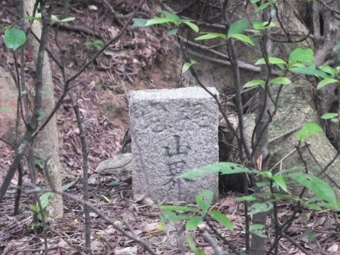
If I go beyond the stone it would be the foot path leading up to the meteological station. As I don't want to be scoded by CM for traspassing next time we meet I did not go any further.
Don't know if this stone is older than houses 29 & 30 there or not. The marker is approximate. I did not bring my GPS this time. On the other hand, I wonder if it has something to do with the cenetery nearby as well.
T
Comments
This Stone reflects.....
Hello tngan,
This Stone reflects a fact that it is the border of Cheungs property over there. That makes sense to explain why local people were not allow to build house near the House #30. If you could line up the location of this Stone with the one inside the St John Hospital, then the line is actually the major divisional line for the European Reservation on old days on CC.
The CC NDB air traffic led-down corridor was basically along this line too. One of the Erythrina Twin Trees was on the line too. The Erythrina Twin Trees were gone around 1970s when Yan Chak Yuen was replacing CTK area.
Recently, I recall a long forgotten 1959 incident about the boundary line. My father rented the CTK site and opened the Ching Tak kindergaten (ie Today's Yan Chak Yuen). But he soon received complaints from the Church ( ie Church of Christ in China ) next door saying his students were trepassing their property. So my father seeked information from the landlord and tried to set up a fence along the CTK limit. As he dug holes for the fence, the landlord's son came up to stop him. He said nothing could be built on that path, a special line in the government's map. He thought there will be a new road going between the Fairy Well area all the way to St John Hospital. He reminded us there was a Stone of such a concern just located near the landloed's property.
Today the Stone near CTK or Yan Chak Yuen , I think. could be found as following:
From School Road, enter the side lane leading to this small group of buildings : Church of Christ in China, Kam Kwong Kindergarten & Nursary and Yan Chak Yuen. And going up to the top of the steps ( about 20 steps or so ),.there used to be a very tiny Y-intersection.( today part of the intersection had been fenced off). The Stone was on that location. It is still about few dozen feet from the entrance of the court yard of Yan Chak Yuen.
I wonder if it still exists there. Would like to find out?....It's near # 11 School Road area.
Regards, Tung
Re: boundary stone 張宅山界
Hi There,
A note. The stone is just a few steps from the path to the weather station. It is also within walking distance from the cemetary down the slopes. There may be similar stones in the neighbourhood marking other perimeters. The marker I set up there is a bit off. I will try to take a GPS reading right on top of it next time I pass it by.
T
Thanks Tngan....
I agree the Stone in Picture is not one of the proper Boundary Stones.
By tradition, certain hillsides are to be considered as good Feng Shui location for the after-life. On CC of my time, we came across numerous urns and grave sites all over the CC hills and hillets, but many of those within the European Reservation area could be subjected to be relocated elsewhere. I think that's why the Cheungs and other property owners would set such stones for avoiding relocation or loss of urns.
The Boundary Stone I mentioned related to the 1959 incident at CTK site (Today's Yan Chak Yuen), as explained on previous posting, was outside the North-end of Shun Tak Tong Xian Hui, behind the rear fance of Tai Sier Tann, and beside the entrance laneway to Yan Chak Yuen.
I can't remember the address clearly. It could be around the #11 School Rd.
Maybe you could also check this out ! Thank you.
Tung
BS near old CTK site seems to be visible on Google streetview...
I just try searching it through the use of internet.....
So Google streetview to #1 School Road, ie the Peniel Church.
At Tai Sun Back Street junction:
Find the ladder laneway nearby, shoot up the view over the steps. First up 8 steps to the flat ground and there stands the open gate with chinese name for Church of Christ in China, Cheung Chau Tong. Keep going up for 16 or 17 steps to the top there is the Y-intersection. Now zoom at this area and see wired fence on the right ( which is the rear side of the Tai Sier Tann ) Can see some plants overshadow a stone pillar. Amazing!!! The bright green spot is a big leaf just over the yellowish pillar which could be the ONE.
The frame page address is
https://www.google.com/maps/@22.2062542,114.029629,3a,75y179.38h,96.08t…!1sFLUkDXYtRTOUM
It seems to me the Boundary Stone is actually in this Google Street view photo......Is it not?
Much appreciated for verifying,
Tung
Oops
My entry https://......is not going to the assigned place. So,
Pls ignore, Tung
Re: CCIL marker stone
Hi Tung,
Are you talking about the one close to the Kwan Gung Pavilion (關公忠義亭) along Peak Road?
T
Nope
I am trying to paste the google streetview on here, but not ssure how to get it right. Poor me....
Anyhow, Back from KGP Temple and go down to the Start location of School Rd, ie the Peniel Church , There is a garbage Collection Depot, by the Junction with Tai Sun Back Str. where you can see the narrow Steppy laneway, an attribute off the School Rd. For 8-and then 17- steps, You should find the Stone is right up in front of you. Good Luck.
Thats what I see from the Google Streetview.
Regards, Tung
Re: CCIL marker stones
Hi Tung,
I have only walked up ro down School Road a few times, but not the side streets. Might have missed the other stone you mentioned. Maybe next visit then, hopefully in spring 2019. Just hope the islanders around the area would not report some stranger walking in loops.
T
And..
You dont need to go to CC.
Using Google Streetview to set foot on the Garbage Depot mentioned, then turn 180 degree. Now the narrow step way is right there. It's like an extension of the Tai Sun Back Str. The houses along this lane carry the same School Rd numbers.
The Stone is actually quite visible to me, since I am very familiar with my old CTK Home yard, even though on the Streetview picture. You may magnify the top of the Stepway. The Bright Green spot is being the Sunlit on a large leaf over the yellowish Stonehead.
However IF it turns out....That is NOT the Stone. THEN KEEP GOING TO YAN CHAK YAN and LOOK AT THE EAST WALL of CCC building, the BS is just few paces away.
Because once upon a time ttere was a BS stone, so no one dare to build house on it in the 1970s. Again I never pay any attention to BS stone back then even it was right clear to one of our window. It posted absolutely meaningless to us. We thought that only concerned the Landlord. For now we the Stone hunters.......could end up finding 2 BS stones on this hillet.: One BS facing the lower land of Tai Sun Back Str.. The next is right off the east wall of CCC Churh in line towards the higher hill of Fairy Well.
By the way, a trip for 2 BS stones sounds good enough, is it not?
Regards, Tung
The step laneway
PASTED IMAGE DELETED
Finally......another 1919 BS stone is here
Now here it is!
In the picture, people walk on School Rd in front of the Peniel Church (hidden outside Pic's left ), towards residence blocks of Golden Dragon Garden. The curved street goes to Tai Choi Yuen but School Rd goes uphill as a fairly wide road with numerous concrete steps, joining Peak Rd on its top.
Over here. the step laneway was strangely assigned to be included as School Rd , I believe, that was due to some outstanding story. So the School Rd on the map appears as a right-angled line. The #1 (Peniel Church) is at the angle point and #2, #3, #4,... runs up east to Peak Rd through the much wider ladder street.
But #12, #13, #14.... strangely runs south from the Peniel Church, up on a much narrow ladder lane up to the terrance of CC's Christ Church in China. Yan Chak Yuen (ie former CTK< Ching Tak Kindergarten), A 1919 BS stone is expected to be found in this area.
Regards, Tung
T
Searching the Missing Boundary Stone of Cheung Chau
Yesterday I list out the locations of the 13 known Boundary Stones according to the 1938 map of Cheung Chau on
https://gwulo.com/media/14135#comment-45997
For the missing one, the hunting ground is around this area:
(1) Along the Yan Chak Yuen (ie former CTK ) steppy alley and
(2) By the East wall of the building of Church of Christ in China.
If each of both locations have the boundary stone, then at least one of them would be a 1919 yr's Boundary Stone.
Tung
Boundary Stone #11....is being behind a wall...from the road
From information on CC history here, it has a picture that BS stone#11 ( supposed to be #4 according to 1938 map), is located in the yard of a private property at the Tin Fok area.
The address is on the top end of Chung Wan Poon San Rd, a ladder way from the end of Chung Hing Str. up to Fairy Well area's Peak Rd. West. Right next to the intersection of the Tin Fok Pavilion. Look north for the wall,
You may need a drone to scan around the view. However if you are so tall like 6' 4"...then the wall is noy a problem at all.
Tung
History about Cheung Chau
Hi, BS Stone-Hunter!
There are two pictures in the below website to be very helpful for the CC BS Stones search.
(1) Including the Heading Photo, the #20th down the right:
There is a picture about the #4 BS Stone according to the 1938 map about European Reservation on Cheung Chau. For the same location of Tin Fok area. The actual number found is being marked as #11.
(2) About #32nd Photo down the right; you see the narrow Step laneway of the shorter School Rd ( for #11, #12, #13 (maybe skipped), #14,...) on the far left in this picture. This is the way to look for 1919 BS#3 (ie marked as BS-12 for real ). You may ignore the wider steps which goes up Tai Shie Tan ( a small shrine ) and Shun Tak District Assoc.
www.rangepcc.com/CC_history.htm
Enjoy,
Tung
Next Time..Just Ask
For CC BS Stone......#4 on 1938 CC map = #11 on real stone next to Tin Fok Pavilion.
Next time at this location (inside the yard of Tsu Yuen by the TFP), Just ask kindly from the landlord or tenants for the permission to view this historical item in the yard
BTW I pinpoint the site through the comparision of the above picture with the Google map's Streetview. The roof, the wall, the wire pole, the background trees, and the color and the texture of the wall of house nearby (ie picture;s right ) are mostly the same regardless different time frame.
Tung
Cheung Chau 1919 BS Stones Search....
More clues coming!
Tung
Try to locate the CCIL 1919 BS#12 by 1938 CC map
On the 1938 CC map. BS#14 (@Hospital), BS#13 (Peak Rd @ Nam She Tong) and BS#11 (next to Tin Fok Pavilion) are all on a straight line.
We may think BS#12 (Between Christ Church in China and Yan Chak Yuen) would be on this line. But it is not. On the map.this area is outside the ER district. Over here are some properties bounded with the dash-dot-dash-dot lines just east of the Fong Pin Hospital area.These are currently or previously European owned . Therefore BS#12 stone needs to 'walk enough' to expand the ER district up to or near the border with Fong Pin Hospital.
Another BS stone is needed. That's the next one (now BS-5 comes into the map), about hundred meters west of Tin Fok BS#11 ( BS-4 on 1938 map). It is closed to today's Tai Shek Hau Electric Transformer Station). It would be BS-5 on 1938 map. Now connecting from here to the BS stone at St John Hospital (ie BS#14 stone or BS-1 on1938 map). We have a second line and BS-3 (ie BS#12 stone ) should be on this line.
If you would really draw this second line. Then a small portion of the line should appear separating the CHrist Church in China from the Yan Chak Yuen (ie former CTK, the Ching Tak Kindergarten) on this hillet between Tai Choi Yuen and School Rd.The same hillet nests also the Fong Pin Hospital and Shun Tak District Assoc.
During the CTK days in 1958 -70, I saw some Stones in our vicinity. One is just so close-by outside one of our windows. By the east wall of the CC in C church building. It seems to me that is within my rusty memory.
However the location is exactly on the second line mentioned above.
By the way same part of this hillet has been the mission field by the London Missionary Society on Cheung Chau during the early decades of 1900s,
Sounds Better?
Tung
CTK photo 1960s
Here,the background: the building of Ching Tak Kindergarten just next to the Twin Erythrina trees. Beyond the 2nd Erythrina tree is the east wall of the old Church of Christ in China, quite pale to be seen under the sunshine effect. A BS stone was in between the two building.
CTK_erythrina.JPG
https://gwulo.com/media/20441
Today the Church is a larger 2-level church building & the former CTK ( ie Yan Chak Yuen ) site stands few blocks of flats. But if there is a BS stone, it should remain on the same spot.
Tung
CC BS stones Hunting Clues
More Clues...
Tung
It turns out....
The BS stone Marked as BS12 is slightly off the CTK site as I uncover the info from the following website
https://hiddenhk.com/boundary-stones
Also once mentioned by someone local, the BS stone was in the middle of the farmer's field between CTK and the Silver Star Primary School. That means it was indeed openly visible to me from the rear yard of CTK during my days there.. My rusty memory convinces me that this information makes good sense too. It was in line of sight with BS stone marked as BS-11 in a house yard at the Tin Fok Pavilion, for 1919, only a very few houses were around the area.
(It also mentions BS-15 was being set up by the beach near the Hospital. I guess it could have been washed away during a typhoon....any suggestion?)
Who would realise the lonely BS Stone in the farmer's field is a ER divisional boundary? Life in the valley of Tai Choi Yuen never magnetise the influx of Europeans. But we know they stay mostly on the Peak Rd...
Today , with the long-disappearance of the old farmer's field, the BS-12 Stone would be at #7A Hi Shi Rd., which is a bit south of Block C of Yan Chak Yuen. The entrance is from the Tai Choi Yuen Rd, opposite to some Nursary. Again, Good Luck if the Stone have not 'walked' away. What about the Stones on CTK,...well they're just not the BS stone I guess.
Tung