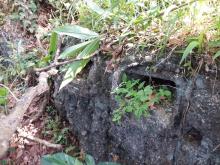
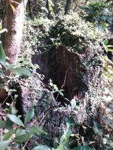
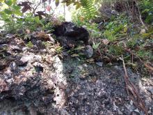
Current condition
Ruin
Date completed
Year completed is: Approximate
Condition at last visit: Ruin
Date of last visit: Apr-1995
Ref: ROB-00528
Other:
Photos that show this Place
2020
2020
2020
Comments
My coordinates are further
My coordinates are further downhill to the west 22.3602984, 114.2202092
As we were quite late and were thus in a hurry, we didn't venture about. My pal who has been there with a hiking group didn't recall visiting another one nearby during that trip. So maybe the one shown in your map indicates that other one.
We reached the pillbox from the Scout Camp, went up some stairs to a small cemetery. Descent on the other side cutting through the jungle, following some tags.
It's quite steep to descend from the pillbox, when we were almost at the Maclehose Trail, the tags suddenly turned right. This was a bit tricky as my map showed that we should be able to continue downhill on a path, but I was not aware of this until I made the right turn for some time. We had to cross another landslide spot in the same day. In the end, the indistinct path led us to the road not far from the Scout camp.
PB 201
Coordinates updated to yours. Thanks.
PB201A
PB201B