Current condition
Demolished / No longer exists
Date completed
Date closed / demolished
Location is approximate, but should be in the neighbourhood of Shan Tung Street. Ceased to operate in late April 1972.
Photos that show this Place
c.1928
c.1933
1944
Comments
Pier location
There was a ferry service between New Western Market (Morrison Street) and Mong Kok Tsui (Shantung Street). It was operational (at least) from 1919.
Mong Kok Ferry Pier (English…
Mong Kok Ferry Pier (English: Mong Kok Ferry Pier) was a ferry terminal in Hong Kong in the past. It is located in the west of Shantung Street, Mong Kok, Kowloon, near Kamlin Street, north of the old Yau Ma Tei Typhoon Shelter, and was later replaced by Tai Kok Tsui Pier. history The Yau Ma Tei Ferry obtained the franchise of the route from Central to Mong Kok in 1923, and officially began to provide services on January 1, 1924, and the Mong Kok Ferry Terminal was opened on the same day. In the 1960s, there was a bus terminus at the Mong Kok Ferry Terminal. At that time, there were KMB 2B, 11C, 12B and 13D. In the 1970s, due to the outdated facilities of the Mong Kok pier, the boats in the typhoon shelter affected the loading and unloading of passengers at the pier, and the hawkers on Shantung Street caused disturbance to the pier, the Yau Ma Tei Ferry chose Tai Kok Tsui to the north to build a new pier. , to replace Mong Kok Pier. On April 22, 1972, the brand new Tai Kok Tsui Ferry Pier was opened, and the Mong Kok Ferry Pier was closed the next day. [1]
https://zh.wikipedia.org/wiki/旺角碼頭
=================================
This is a picture captured from a 1965 French movie "Up to His Ears" (Les tribulations d'un Chinois en Chine)
It shows the Mongkok pier going to a fictitious place called "Sey Chang". Compared with the street view today with the Yuen Fat Building 源發大廈 in the background. It was under construction in 1964. The date of 0ccupation was 26/10/1965
https://www.midland.com.hk/zh-hk/estate/九龍-旺角-源發大廈-E10249
==================================
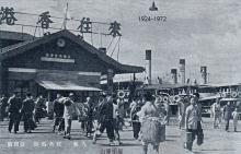
1944
In 1944, it looked like this:
1966
1966 looking west from the Shantung street-Canton road junction.
Mongkok ferry Pier
More screen shots of the area can be seen here: https://hkmacaufilmtvlocations.blogspot.com/2016/11/les-tribulations-d-…
Was it called Mong Kok Tsui…
Was it called Mong Kok Tsui Pier prewar? Or is that another pier? I am wondering because if it is indeed the "Mong Kok Tsui Pier", the completion date of 1924 is false similar to Shamshuipo Pier.
Re: Mong Kok Ferry Pier
Hi There,
As far as I could recall, not quite. There is another ferry pier nearby (quite a few city blocks away) called Tai Kok Tsui Ferry Pier though.
T
Re: Mong Kok Tsui Ferry Pier
Tenders were invited for the construction of Mong Kok Tsui Ferry Pier in April/May 1929. By the end of 1930, construction work was nearly completed except for the roofing over the pier.
The roofing work was completed at the end of June 1931 and the Ferry Co. transferred from the temporary pier (?) to the new pier in July.
Sources:
(1) Item 177 in the Report of Public Works for 1930
(2) Item 235 in the Report of Public Works for 1931
history
Mong Kok Ferry Pier and Tai Kok Tsui Ferry Pier were two different piers operating at two nearby locations at different times.
Mong Kok Ferry Pier 1924-1972
Tai Kok Tsui Ferry Pier 1972-1992
https://zh.wikipedia.org/wiki/%E6%97%BA%E8%A7%92%E7%A2%BC%E9%A0%AD
https://zh.wikipedia.org/wiki/%E5%A4%A7%E8%A7%92%E5%92%80%E7%A2%BC%E9%A…
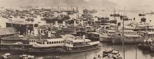
An aereal photo showing both piers in 1972. The latter was built to replace the former.
https://gwulo.com/media/44277
If you check the 1920 200…
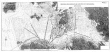
If you check the 1920 200-feet-to-1-inch "Map of the Kowloon Peninsula (including portion of New Koloon)" in the UK National Archives, the vincity of the Shan Tung Street pier was indeed called "Mong Kok Tsui".
The area was also labeled "Mong Kok Tsui" in this ferry route map from 1928.
Aerial photograph of the vicinity (sortie PEGASUS/RN/H/0027, frame 0028) on 14th November, 1929 also shows no concrete structure. Only a number of wooden/makeshift piers can be identified. I suspect the small pier in the place of the "future" Mong Kok Tsui pier with a relatively long boat with closed (white) top next to it was the temporary pier mentioned in the Report of the Director of Public Works for the year 1931.
Also as mentioned by moddsey, the tender for the reinforced concrete pier that is known as "Mong Kok (Tsui) Ferry Pier" later was not issued until 19th April, 1929.
It does look as though the…
It does look as though the original name was "Mong Kok Tsui Ferry Pier". As well as the mentions in the PWD reports, that name is also used in the Blue Books for 1930 and 1932. A Google Books search for that name didn't find any other matches.
A Google Books search for "Mong Kok Ferry Pier" returns four results, from 1946-1970.
So the name appears to have changed some time between 1932 and 1946.
After surfing through the…
After surfing through the collection of maps that cover Kowloon at hkmaps.hk, it appears the waterfront area near the typhoon anchorage is usually referred to as "Mong Kok Tsui" while the inland area near the hills is called "Mong Kok". This convention can still be found on some maps (examples from 1963 and 1965) from the 1960s but no more since the 1970s.
Rather unexpectedly, the Wikipedia Cantonese has an entry that contains the most detailed info on the name. "Tsui (嘴)" is actually a reference to the estuary of a stream from Ho Man Tin that is shown on this map from 1880.
Combined with information in the Wikipedia Chinese entry, we know that the area was called "芒角嘴" in chorographies published by the Qing Empire from the 1810s allegedly for its plentiful supply of ferns. English transliteration "Mong" was allegedly from Tanka (boat) people's (蜑家人/艇家人) pronunciation of "芒" which is closer to that of "望" in Cantonese. So "芒角嘴" gradually became "望角嘴". A newpaper article from 1895 already uses "望角嘴" instead of "芒角嘴".
Mong Kok Tsui vs Mong Kok
Yes, Mong Kok Tsui would normally refer to the seaward side of Mong Kok.
However, Mong Kok Tsui was also used to describe the Police Station, market etc., that were situated inland.
A good indicator of description of the area and the gradual name change from "Mong Kok Tsui" to "Mong Kok" can be viewed from Government Notices of Land Sales. See: https://sunzi.lib.hku.hk/hkgro/result.jsp?total=125&no=20&id=2&first=101 or type in "Mong Kok"
route
Regarding "There was a ferry service between New Western Market (Morrison Street) " in above comment. It is not quite correct at least in the 1960s. The pier here operated between Shantung street and the united pier which was rather in the neighborhood of Central market.
https://gwulo.com/media/46342
https://gwulo.com/node/59574#17~22.28492~114.15686~Map_by_GovHK-Markers…