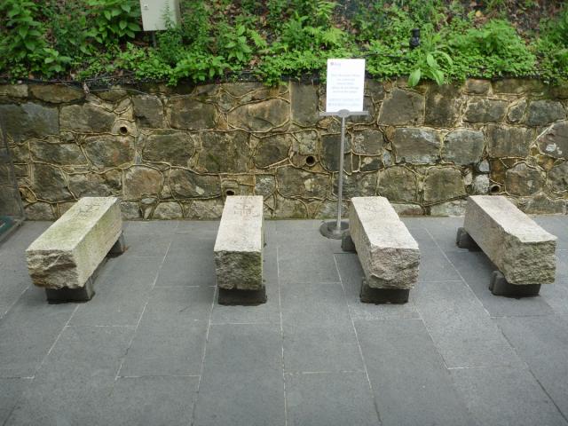
Left to right they are numbers 103, 104, 105 and 100.
I was pleased to see these - I'd noticed one of the old stones (#100) had disappeared from the road outside the magazine area during the construction project. I'd thought it was a goner, but they'd been kept and here they are.
Date picture taken
21 Apr 2012
Gallery
Shows place(s)
Comments
Naval Boundary Stones - Former Explosives Magazine
Re: Naval Boundary Stones - Former Explosive Magazine
Thank you, moddsey and David. Where were the boundary stones originally located?
Re: Naval Boundary Stones - Former Explosives Magazine
From a wall plaque:
'Hidden in undergrowth that encircled the site (Asia Society Hong Kong Centre), these granite military lot markers were rediscovered when the Former Explosives Magazine was handed over to the Society in 2005. The stones were found at various points on the periphery and served to mark the boundary and owner of Victoria Barracks. The anchor and "1910" engraved on each marker indicates the year in which the British Army transferred ownership of the land to the Royal Navy. The numbers found above the anchor are believed to be registration numbers. The four stones were a reminder of the Admiralty's unique history and maritime past.'
Re: Naval Boundary Stones - Former Explosives Magazine
Thanks moddsey. I thought that everything south of Queensway belonged to the army, but I was wrong.
The former explosives magazine "......was originally built by the British Army in the mid-19th century for explosives and ammunition production and storage. It was then expanded and taken over by the Royal Navy in the early 20th century. The site was later abandoned in 1990s......" (from Asia Society web page).
Navy land
The Royal Navy had most of the south-east corner of the land below Kennedy Road. The magazine (http://gwulo.com/node/5080) was the main building, but there was also a laboratory building further west, near where the Regent on the Park is today. They were both linked to the Navy's land north of Queen's Road / Queensway by an aerial ropeway (http://gwulo.com/cable-car-over-queensway).
Source: Map in SMO library, their ref: HG7.
Re: Navy land
Thanks David. I remember the ropeway but forgot it belonged to the navy. This is the area near the mysterious iron door, too.