Named after:
The Hong Kong Royal Mint
Chinese names:
Yet to be discovered
Timeline:
- 1866: Street named
- 1868: The mint closed
- 1882: First appeared on maps
- 1889: Last appearance on maps
Other information:
From the source,
In the late 1860s, there was an attempt at local coin production at the Hong Kong Mint in Causeway Bay, but it didn’t gain much traction. The Mint closed in 1868, and its site was later acquired by Jardine Matheson, eventually becoming the China Sugar Refinery Co.
It stated that the street was disappeared in the 1890s, and on the 1889 map, the street with name labelled was last seen from any kind of maps. Many more maps until 1930s have this street but without name label, so it doesn’t really count. 1900 was actually the first map showing other streets but not this, so I’ll put the closing date to the end of 1899.
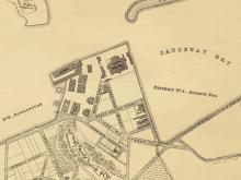
The area of the street shaped the adjacent lots, such as ML 52 on the west and IL 469 on the east, the street literally cut through the lots. The area also partially resembles the original land of East Point, from the geoinfo map, inland lots are roughly East Point, while marine lots are likely the beach or the harbour itself.
Sources:
HK maps viewer
Hong Kong Mint (Wikipedia Link)
How trade shaped Hong Kong street names
See also:
Mint - Causeway Bay
Photos of this street:
Comments
Re: Royal Mint Street
Hi there,
I had been scratching my head about lot numbers and the shapes of some adjacent lots. This street seemed to be the answer.
T
Site of Hong Kong Mint
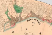
To assist readers understanding this discussion. I am attaching an extract from a 1866 Plan of Victoria Harbour which indicates the site of the Mint. It is the red block No 38 on the Harbour seat front ( near the Bottom left-hand corner of the plan ) . The Plan of Victoria was published in the Chronicle & Directory of Hong Kong, China ,Japan & Corea Etc. Etc. Source of this extract from the Website Hong Kong Historic Maps
About the discussion on the street
Thanks Chinarail attaching a 1866 map to assist readers with the discussion. I have also uploaded 2 relevant maps to also assist future readers, which features the street itself and the nearby lots and areas. Both are sourced from HK maps viewer.
And for Tngan, I have added a paragraph to acknowledge your findings on the lot shapes and numbers.