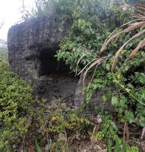
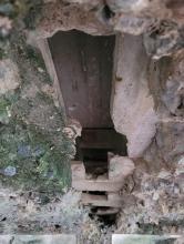
Submitted by Rob on Tue, 12/18/2012 - 21:47 +−17 Map by GovHK Map by ESRI Map by OSM Map by Thunderforest Satellite by GovHK Markers 1845 HK 1866 HK 1873 HK 1896 Kowloon 1901 HK 1903 Kowloon 1905 HK 1909 HK 1912 Peak 1920 Kowloon 1924 HK 1924 Peak 1938 Cheung Chau 1939 NT 1945 HK+Kln 1947 Kowloon 1952 All 1956 Kowloon 1957 HK 1958 HK 1960 Harbour Leaflet | Hong Kong Geodata Store Current condition Ruin Date completed 1 Jan 1937 Year completed is: Approximate Condition at last visit: Ruin Date of last visit: Oct-1992 Ref: ROB-00502 Other: Tags pillbox 2 Loophole Mainland PB Log in or register to post comments Photos that show this Place 2025 2025 2025 Comments New coordinates 22.32906 114.27220 PB102 trench, by ck89 PB102, by ck89 PB102_2, by ck89 PB102_3, by ck89 Log in or register to post comments Pillbox 102 Coordinates updated. Thanks. Log in or register to post comments PB102, by pwau98 PB102, by pwau98 Log in or register to post comments Went there yesterday Went there yesterday , no path can be access to the PB from the road , maybe I'll try to climb the rocks from the beach next time Log in or register to post comments Today's PB102, by GinoRocksen Wong PB102, by GinoRocksen Wong PB102, by GinoRocksen Wong PB102, by GinoRocksen Wong Log in or register to post comments
New coordinates 22.32906 114.27220 PB102 trench, by ck89 PB102, by ck89 PB102_2, by ck89 PB102_3, by ck89 Log in or register to post comments
Went there yesterday Went there yesterday , no path can be access to the PB from the road , maybe I'll try to climb the rocks from the beach next time Log in or register to post comments
Today's PB102, by GinoRocksen Wong PB102, by GinoRocksen Wong PB102, by GinoRocksen Wong PB102, by GinoRocksen Wong Log in or register to post comments
Comments
New coordinates
22.32906 114.27220
Pillbox 102
Coordinates updated. Thanks.
PB102, by pwau98
Went there yesterday
Went there yesterday , no path can be access to the PB from the road , maybe I'll try to climb the rocks from the beach next time
Today's