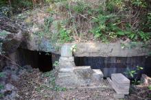
Submitted by Rob on Tue, 12/18/2012 - 21:47 Current condition Ruin Date completed 1 Jan 1937 Year completed is: ApproximateCondition at last visit: RuinDate of last visit: Feb-1995Ref: ROB-00519Other: Different design to all other PB's. Tags pillbox Mainland PB 2 Loophole Log in or register to post comments Photos that show this Place ???? Comments PB119 PB119, by pwau98 Log in or register to post comments May I have the coordinate ? May I have the coordinate ? Log in or register to post comments Coordinates: 22.33966 114… Coordinates: 22.33966 114.22981 Log in or register to post comments
Comments
PB119
May I have the coordinate ?
May I have the coordinate ?
Coordinates: 22.33966 114…
Coordinates: 22.33966 114.22981