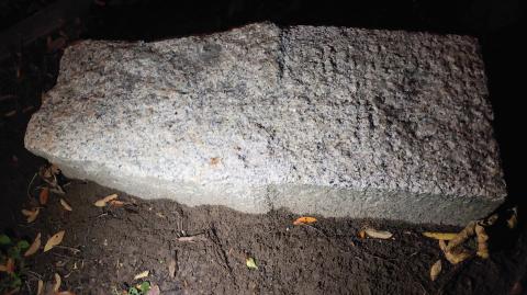
A granite marker stone was noticed in the former King's Park in Kowloon.
Top inscription
' 5 F T. "
'T O 9 0 Y'
Was it a distance marker?
A granite marker stone was noticed in the former King's Park in Kowloon.
Top inscription
' 5 F T. "
'T O 9 0 Y'
Was it a distance marker?
Re: Granite Stones
Could you elaborate and advise where were these granite marker stones found?
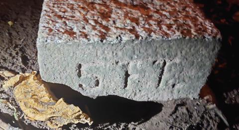
Granite stone - Historic King's Park
A better look of this granite marker inscription showed
5 F T .
T O 8 0 Y
This marker stone is not easy to access and one side is a slope. For safety purpose, I would comment the location is within historic King's Park.
Using online historic map search and through the GRS service, there was no definite construction at the present location of the granite marker. From the inscription, it is unlikely a Lot stone.
The next thought is the upper panel "F". It is not a usual capital letter F. My initial thought was a symbol of something. I do not have an idea even after browsing online pages of "Symbols". I was convinced it is a letter "F" by a librarian who write a short note for me on a memo at the Map library, Central library. I thought it is a calligraphy letter F.
The best guess of " 5 F T . ' is "5 feet"
For the lower panel, the initial thought was
" T O 9 0 Y " or " T O B O Y "
I thought it was a distance marker as if " To 90 Yard "
The idea of representing a boy's latrine or lavatory also come across as the inscription " T O B O Y ".
Later, a better look of the inscription using aluminum foil suggested " T O 8 0 Y ".
The online historic maps website helps. With respect to the current granite stone location, there were historic "Rifle ranges" on the map around 1900s.
Further searching the online maps and GRS map holdings, the long rifle ranges has regular interval 100-yard markings shown on the map and that may represents rifle mound or pits. Most of the rifle ranges were from Gun Club Hill. There are old maps of Kowloon Peninsula, printed early in 1896, suggested some short "Ranges" within King's Park region as well.
According to a proposed Rifle range extension map in King's Park from GRS holding, a short 50 Yard Range with an interval of 10-yards spacing with "shelter" are drawn on a sketch map. There was a specific description as well.
FRONT ELEVATION
1/2" DETAILS OF SHELTER
HEIGHT FOR 50 YD. RANGE = 8!0"
40 = 9!0"
30. = 10!0'
The closer to the targets, the height of shelter is higher.
After seeing this description on the map, I propose all Range construction are following some standard military guideline or pamphlet.
What if it is a 80-Yard Range?
The front elevation of 1/2" details of shelter will become ...
HEIGHT FOR 60 YD. RANGE = 7!0"
70 = 6!0"
80. = 5!0"
80 YD 5 FT.
Is it a coincidence to have this
" 5 F T. "
" T O 8 0 Y " ?
Is this a marker stone of a historic short Rifle range?
Any suggestions? All are welcome!
King's Park, Historic Rifle range
Upon searching related online photos of King's Park region, two photos caught my eyes. At the back of the B/W photo of a navy group, it put down "on the Rifle range, Kowloon, 9 January 1901". The later aerial photo showed similar boulders which appeared quite corresponding, at the previous Naval Association Rifle Range.
re: Granite stone - Historic King's Park
Herman, thanks for uploading the clearer photo of the marker stone.
My guess for the text is: 5FT TO BDY, or "FIVE FEET TO BOUNDARY".
Normally a boundary marker stone is placed on the boundary, but you mentioned there is a slope nearby. If the boundary was on or near the slope it may have been difficult to erect a stone there, or safer to indicate the boundary from a short distance away.
Aluminum foil for inscription reading
Thanks!
Possibilities!
For the lower panel the third letter / number / symbol, I thought it is '9' at the very beginning with palpation. Using aluminum foil, the possible answer will be either "8" or "B".