Current condition
Demolished / No longer exists
From the 1901 Map
On (K) I.L. 535
Kimberley Road originally curved to the north just west of the junction with Carnarvon Road, joining Nathan Road where Observatory Road joins. It was straightened to its current alignment c1910
Photos that show this Place
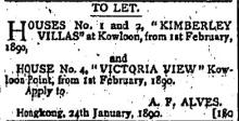
1890

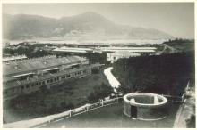
c.1890
1897
Comments
1892 Kimberley Villas
An early reference of Kimberley Villas can be found in the Directory and Chronicle for China & Japan etc., for 1892
Two buildings
The 1896 map shows Kimberley Villas as a single building on KIL 535, with lots 533, 534, and 541 around it: https://gwulo.com/node/46364#19~22.30097~114.17265~Map_by_GovHK-Markers…
On the 1920 map, lots 535 and 541 have been merged into KIL 535, and lots 533 and 534 have been merged into KIL 533. The original building is still on KIL 535, and there's a new building on KIL533: https://gwulo.com/node/46364#19~22.30089~114.17265~Map_by_GovHK-Markers…
Moddsey notes:
A search for Kimberley Villas shows several addresses with numbers 3 & 4.
I believe the two buildings were collectively known as Kimberley Villas, with the older building being numbers 1 & 2, and the newer building numbers 3 & 4.