Current condition
Demolished / No longer exists
Date completed
(Day, Month, & Year are approximate.)
Date closed / demolished
(Day, Month, & Year are approximate.)
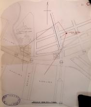
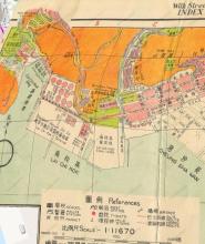
Referred to as a 'coal bunker' on the 1952 map, and 'Lai Chi Kok coal yard' on the 1956 Kowloon map. It seems to have covered quite a large area.
By 1968, the coalyard had been replaced by the Lai Chi Kok Incinerator, as can be seen on one of the photos here: https://gwulo.com/node/30761 (see also the 1970 HK map on https://www.hkmaps.hk/viewer.html)


Comments
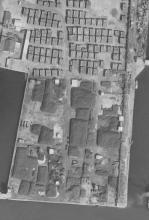
I’ve found the photo
The bunker in 1963, captured by the government's aerial survey.
Thanks for adding the photo
It's good to have a clear, detailed image of the coalyard - and to have the large scale of it confirmed.
Coal Yard
this site is still free of development to this day - it's a KMB bus storage shed and public carpark.
Re: Coal yard at Lai Chi Kok
The coal yard was located on (New Kowloon Marine Lot) N.K.M.L. No. 8. This lot is shown on the 1923 map already added to this place.
The Public Works Report for 1926 refers:
N.K.M.L. 8, Lai Chi Kok (completed), 514,150 sq. ft.
So 1926 or 1927 would be the earliest date of operation. The coal yard can be seen on an aerial photograph from 1934 on hkmaps.hk.
industrialhistoryhk reports from around 1940:
Ample bunkering facilities are provided by stocks of coal which average about 100,000 tons, mainly from the Kaiping and Japanese mines. Coal is taken alongside the coaling camber and piers at Kowloon or the K.M.A. [likely Kaiping Mining Association] wharf at Lai Chi Kok; about 2,000 tons can be loaded in 24 hours. Vessels moored in the harbour coal by baskets from junks or lighters.