Current condition
Ruin
It's marked with the word "pillar" somewhere near the abovementioned site in the 1960 map layer.
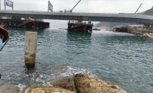
I was there at Chiu Keng Wan a couple of days ago and found a lone pillar still standing in the sea close to the shore.
It can be seen in the middle of this photo:
https://maps.app.goo.gl/NwHm53ser6ZM9wZc8
Maybe at low tide, one can reach the pillar:
https://maps.app.goo.gl/39SbipNa34aNCPBx8
Does anyone know what was it for?

Comments
I'm having trouble seeing
I'm having trouble seeing which area you mean. I've changed this page to be a Place. Please could you edit it and move the marker to the right location?
Re: Pillar
Hi David,
I believe Lo is refering to this map\chart.
T
Re: Pillar
Hi Lo,
I browse the chart to the very bottom of it and found it originated from an Admiralty Chart dated much earlier than 1960. The numbers on the chart back then are likely in Imperial System. And Admiralty Charts usually state the depths using the unit of Fathoms.
The location of the Pillar are in deep waters despite it is close to the shore. Your photo showed that. The '2' close to it probably means 2 fathoms, which is 12 feet.
If you intend to 'walk' out there you would probably need diving gears.
T
That's where I was. But why
That's where I was. But why is there only one single pillar for the Junk Bay? The place east of the Bay, the same latitude is called Pak Shek Kok, meaning White Rock Corner/Head in Chinese. I am wondering if there's a pillar at this place too. If so, then the two pillars might have marked where the cables went into the sea... but why was there the need for cables in those days, were they for telegraph? Any military structures in the eastern side of the Bay?
I have just posted a photo with me standing close to it, perhaps within 2 metres apart, I could see its base through the water.
The hill behind was called Mun Chau, for which I can't find its name in Chinese.
P.S. I have added the coordinates, it's the data I got from the closest point where I could stand on land.
Re Pillar
Hi Lo,
I did not see the pillar from the previosu aerial photos. Anyway, the submerged section looked older than the top.
T