Seating capacity: 1,261
Address: Bulkeley Street, Hung Hom, Kowloon, Hong Kong. Hing Bank Building is the current occupant at the site. The theatre was located either at the northeast corner of the Gilles Avenue South - Bulkeley Street intersection, or, more likely, the northwest corner of the Bulkeley - Kun Yam intersection. (Edit: August 3, 2021 - Location marker corrected as per informarion provided by reader below.)
Information collected thus far reveals only general information including its address. One source listed below states that it was opened some time in the early 1950s, and it was closed in July 1970. The Hunghom Wing Lok Theatre Company Ltd. was incorporated on March 28, 1952 and its date of dissolution was February 14, 1975. Hence, one may assume that the theatre took about a year to build which would put its opening date sometime in 1953.
Sources:
- Cinema Treasures: http://cinematreasures.org/theaters/28708
- Who's Who: https://webb-site.com/dbpub/orgdata.asp?p=157042
- Hong Kong Theatres Association Limited: http://hktaorg.com/en/cinemahistory.php
Photos that show this Place
Comments
Where is Wing Lok Theater
The address of this theater appeared in an old Chinese newspaper 大公報, 1970-05-18, page4. There was an assault incident on theater staff the day before. The address was given as Walker Street. So it must be at the site of one of the residential buildings there at the intersection of Walker and Bulkeley Street because most sources put the location at Bulkeley Street too. There is one other source which has the location on a 1960s map at the south-west corner of that intersection (second link below). The photo showing the theater at Chatham road is quite puzzling. Possible explanation is that it has moved in the 60s.
https://mmis.hkpl.gov.hk/coverpage/-/coverpage/view?_coverpage_WAR_mmis…
https://talkcinema.wordpress.com/2011/06/30/%E5%85%AD%E5%8D%81%E5%B9%B4…
Wing Lok Theatre
Thank you simtang for the information. I have moved the marker as per your advice. The map (your second link) was helpful. While it was difficult to see clearly the names of the old streets, the curved Ping Chi Road just to the north confirmed the location. The sign on Chatham Road was likely placed there to attract travellers. Regards, Peter
chatham road sign
That photo showing the "Wing Lok theater" sign is really old.There is a photo showing a gate built around that location on Chatham road celebrating the coronation of Queen Elizabeth II with that sign in the background. That means the theater existed already before June 1953. Your photo is also quite old, possibly taken in the 50s because it shows a bus coming out from Bulkeley street. We know there was no traffic on Bulkeley street in the 60s because the road was occupied by street hawkers. That place was known as the "Bulkeley Market". Looking more carefully, your photo also shows part of that gate built in 1953 (the column of the gate on the right).
rare photo of the theater
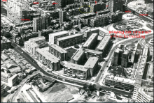
The other day I came across a 1968 aerial photo of Hunghom village published by the Hong Kong Housing Society. I discovered that it also has captured the Wing Lok theater. Though it is from a distance, it doesn't look like the residential buildings surrounding it. It is at the southwest corner of the walker-bulkeley junction. There is also the Bou Lee building built in 1964 at the northwest corner of same junction which still exists today. The Bou Lee building in the photo can be compared with the one on Google map. Therefore the building with a yellow circle around it should be the Wing Lok theater (the front end of it). Note that the camera was facing south. One can see the Hunghom pier or rather a ferry boat at the upper left corner of the picture. I am also wondering what that huge building at the upper left corner of the picture is. Looking at Google map, it actually is the Whampoa building built in 1967. I never realized it is that tall.
https://www.hkhs.com/tc/housing_archive/id/14/scheme/4
Wing Lok Theatre / 永樂戲院 [1953-1970]
Thank you simtang for the additional information. I looked it up on the 1963.2 air photo and noted the juncrion at the theatre was the busiest place in that part of town. The 1956 street map shows a market on the northeast corner and high pedestrian traffic.
In those days, a student monthly bus ticket had four tiny circles for each day for the conductor to punch out a hole. Since my trip to Good Hope used only two circles, I had surplus (and time also) to include TST as part of the trip. That part of Chatham Road was, I believe, part of my trip and I seem to remember the tiny hill by the road. Regards, Peter
Bulkeley market
Indeed there was street market there up till the 80s. According to a news article the Bulkeley market started operation in 1952 in that small building on the left to replace the one at Ma tau wai-Wuhu street junction. Graduately hawkers started to appear around it. Probably there was another building on the other side of Gillies Road according to some old maps. In 1987 the market moved to the new Municipal building on Ma Tau Wai Road opposite the station lane. Like the one on Temple Street, the hawkers occupied the road and no car traffic was possible there. It was called the Bulkeley market though the hawkers there were likely without license. It ran through almost the whole length of Bulkeley street. Below is a 1977 photo of the market at the Gilles Road junction looking east. Unfortunately I can't find any photo of the market on the west side of Gilles Road where the Wing lok cinema was located. It is not surprising it was always busy around there. One needs to pass through the market in order to get to the cinema.
==========================================================
This photo is the only one I can find of the part of the Bulkeley market west of Gilles Road. Photo probably was taken from valley hill next to Chatham Road with camera pointing east and down. Though at a distance, one can see a lot of hawker stands filling the Bulkeley street (circled with red rectangle) and back alley too. Wing Lok cinema is too short to be seen assuming it hasn't been demolished already. Apparently Fok Lin building was under construction. So year of photo probably around 1972-1973.
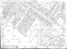
1965 map
This 1965 map from www.hkmaps.hk clearly shows where the cinema was. The building is labelled as "Wing Lok Theatre"
The "official" Hunghom market is also shown as the two buildings on both sides of Gilles road. The whole Bulkeley street was also known as the unofficial Hunghom market or Bulkeley market filled with street vendors. No wonder it was very crowded around the cinema.