Submitted by simonho on Sat, 03/21/2020 - 12:07 Current condition Ruin Tags BP marker stone Log in or register to post comments Photos that show this Place ???? Comments This marker stone was set up This marker stone was set up here to indicate some military facilities were nearby. Besides, the public work department was also use this stone as a trigonometrical point. Log in or register to post comments Some paved steps leading up Some paved steps leading up to a trench around the hilltop where this stone is. How did you reach it? Log in or register to post comments
This marker stone was set up This marker stone was set up here to indicate some military facilities were nearby. Besides, the public work department was also use this stone as a trigonometrical point. Log in or register to post comments
Some paved steps leading up Some paved steps leading up to a trench around the hilltop where this stone is. How did you reach it? Log in or register to post comments
Comments
This marker stone was set up
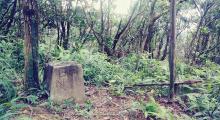
This marker stone was set up here to indicate some military facilities were nearby. Besides, the public work department was also use this stone as a trigonometrical point.
Some paved steps leading up
Some paved steps leading up to a trench around the hilltop where this stone is. How did you reach it?