Starting from Tai Lam Wu Rd, take the road/track/path in the direction of Kau Tsin Uk for roughly 100m. Turn right, crash through the vegetation. It's in there somewhere. There is debris, according to my notes that is what got me to the PB. The PB remains are the usual walls, with a possible trench/tunnel at the rear right corner. It was VERY heavily overgrown in 2006.
I followed the path that you mentioned. I would like to know whether the PB is at your right hand side when crashing through the vegetation. Thank you.
I suspect that the PB was to the left of my original entry, as the debris took me to the front. When I eventually came out it was to a path and fence above the village, so it wasn't behind my original entry line.
It's a pity that I only read this page now, hence I haven't spent time searching for the walls and tunnel. My hiking pal said that the group he followed last time only knew about that one block of debris found.
I can't say what is there now, but in Dec 1996 there was the standard ruin of a PB i.e. side and back wall, with partial front wall of a two loophole type. There was a possible collapsed tunnel leading to the right side at the rear, but because of the vegetation it could not be investigated. Similarly, the ruins were extremely overgrown.
I'm trying to visualise the access to it. On the road to Kau Tsin Uk there was a fence with an adjacent path leading off to the right, and around the same point on the left was a vehicle track leading to something like a house. I entered the vegetation before this point to the right side of the road, in what appeared to be a lighter area of vegetation, and worked in the direction of KTU, until I came to the left side of the PB. When I left I worked from the front of the PB towards KTU in the hope it might be easier than trying to go back. After some unknown distance I came out to the fence and path, probably 50 metres from the road.
I hope this may help, but please consider it is done from a memory of 14 years ago.
It's incredible that you can still recall so many details, it's impossible for me now.
My coordinates are 22.3518883, 114.2367215 ...
Maybe I haven't reached deep enough for the ruins.
When I ascend from the stream in Ho Chung Valley, I turned right then started uphill. After taking the left branch for a flight of steps instead of continuing with the path ahead, I reached a road where two Rottweilers barked at me through the gate.
After passing another junction at which I still took the left one, I left the road near a street lamp post for the jungle.
From those pictures provided by ck, I believed we might be taking the same route.
From this link, you may find that there's still no other construction in that area to destroy the ruin completely...
Comments
Anyone has more information
Anyone has more information about the location of this PB?
I couldn't find any sign of it, even some concrete debris :(
PB 122
Starting from Tai Lam Wu Rd, take the road/track/path in the direction of Kau Tsin Uk for roughly 100m. Turn right, crash through the vegetation. It's in there somewhere. There is debris, according to my notes that is what got me to the PB. The PB remains are the usual walls, with a possible trench/tunnel at the rear right corner. It was VERY heavily overgrown in 2006.
Hi Rob
Hi Rob
I followed the path that you mentioned. I would like to know whether the PB is at your right hand side when crashing through the vegetation. Thank you.
PB 122
I suspect that the PB was to the left of my original entry, as the debris took me to the front. When I eventually came out it was to a path and fence above the village, so it wasn't behind my original entry line.
Still couldn't find it
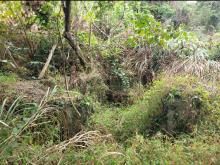
I found a way crashing into the vegetation but I only found some debris near the pin location
I doubt that those debris do not belong to the PB
Entrance into the vegetation
PB 122
The last photo is a possibility, but I don't think the others are. All I can offer is that it is in there somewhere.
It's a pity that I only read
It's a pity that I only read this page now, hence I haven't spent time searching for the walls and tunnel. My hiking pal said that the group he followed last time only knew about that one block of debris found.
I am still questioning about
I am still questioning about the exact location. Is it possible that all the walls were removed?
PB 122
I can't say what is there now, but in Dec 1996 there was the standard ruin of a PB i.e. side and back wall, with partial front wall of a two loophole type. There was a possible collapsed tunnel leading to the right side at the rear, but because of the vegetation it could not be investigated. Similarly, the ruins were extremely overgrown.
I'm trying to visualise the access to it. On the road to Kau Tsin Uk there was a fence with an adjacent path leading off to the right, and around the same point on the left was a vehicle track leading to something like a house. I entered the vegetation before this point to the right side of the road, in what appeared to be a lighter area of vegetation, and worked in the direction of KTU, until I came to the left side of the PB. When I left I worked from the front of the PB towards KTU in the hope it might be easier than trying to go back. After some unknown distance I came out to the fence and path, probably 50 metres from the road.
I hope this may help, but please consider it is done from a memory of 14 years ago.
It's incredible that you can
It's incredible that you can still recall so many details, it's impossible for me now.
My coordinates are 22.3518883, 114.2367215 ...
Maybe I haven't reached deep enough for the ruins.
When I ascend from the stream in Ho Chung Valley, I turned right then started uphill. After taking the left branch for a flight of steps instead of continuing with the path ahead, I reached a road where two Rottweilers barked at me through the gate.
After passing another junction at which I still took the left one, I left the road near a street lamp post for the jungle.
From those pictures provided by ck, I believed we might be taking the same route.
From this link, you may find that there's still no other construction in that area to destroy the ruin completely...
https://www.map.gov.hk/gm/geo:22.3514,114.2371?z=2257
That's brilliant Rob. You
That's brilliant Rob. You have already helped me alot.
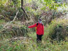
Found yesterday
I found PB122 yesterday