Current condition
Ruin
Date completed
Year completed is: Approximate
Condition at last visit: Ruin
Date of last visit: Oct-1995
Ref: ROB-00532
Other: Destroyed in fighting Dec 41
Photos that show this Place
1993
1993
2020
Comments
DSCN4211.JPG, by mikael
Ruin of PB205
Location
Coordinates : 50QKK1260877215
22.3769369, 114.2091079
This differs a bit to the record on the map ... The yellow dot should be somewhat in the NNE, closer to the path.
Anyway, it's not hard to find, for it's beside a dirt path leading up from Ngau Pei Sha.
The pillbox is indeed next to
The pillbox is indeed next to the dirt path,
Correct
That's what I meant.
If the base map can have more contour lines and various info, such as country trails, it would be much easier for us to locate the exact place.
An alternative is to allow us to choose more than one base map...
PB 205
Sorry that the co-ordinates seem a bit out, but at this stage I cannot correct them. Unfortunately, the type of co-ordinate on your phone will not be accepted by the transformation tool. The choices are basically map co-ordinates from the current HK Maps, or lat and long. This applies to all those you have pointed out.
UTM coordinates
Those coordinates provided by me are of the UTM system, i.e., the one used by the country map and topographic map printed by the Lands Department.
PB 205
I use the Lands Department Transformation Tool to convert the different coordinates types to decimal lat. and long. for use on Gwulo. At present, I have been unable to convert your UTM to decimal degrees on either of the versions. I will keep working on it.
Field visit Sun 20 Sep and some advice if you want to go
I paid a visit to the site yesterday, and took some pictures. I'm new here and I'm not sure how to add images yet (what's an atom?) so I'll leave them for a future comment. I found what looks like part of the access trench/tunnel after accidentally slipping and falling through some brush, but I'm not certain. The place now looks similar to previous pictures, except the grass is taller and greener.
The path from Ngau Pei Sha village isn't very clear and I didn't know how to get up there from the village, so I took a route from the Tate's Cairn tunnel entrance, which took me up a taller mountain to the south before I descended from there onto the hill where the pillbox was located. I then walked down to Ngau Pei Sha village from there. The path along the entire trail is very overgrown so bring a buddy and beware of snakes and other critters.
Along the trail up from Ngau Pei Sha, fairly close to the pillbox you'll find a short but very steep ridge which you will have to climb up. Someone put up a rope, but not recommended if you're bringing anything heavier and bulkier than a backpack. The trail I took, from Tate's Cairn Tunnel, is a little more friendly for hikers, but is significantly longer. The entire route in general isn't very friendly for hikers anyways, with steep dusty trails and little foothold. Expect to slip at least a few times, and expect to get dusty by the end of the day. Bring a walking stick, you'll need it for the descent. Only attempt if you're an experienced hiker, which I am not.
Oh and just some general advice: watch your valuables. I dropped my phone along the trail, and it's not easy finding it when it's somewhere in the bushes. Fortunately I did end up finding it.
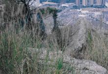
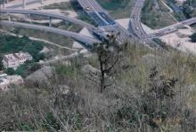
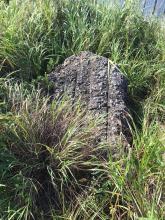
Images for my earlier comment
I figured out how to add images, so here you go.
The access trench looks much larger in the picture than it actually is, it's about knee height and you can only see it if you sit down in the undergrowth. I took the second picture standing on a chunk of pillbox and the access trench is to the left of me in that picture. It could actually just be part of the bit of well preserved wall, but I didn't investigate much as the vegetation was hard to move through.