Current condition
Demolished / No longer exists
Date completed
(Day & Month are approximate.)
Date closed / demolished
(Day, Month, & Year are approximate.)
Old houses on Peking Road (Inland lot 416, see 1896 Kowloon map), probably numbers 1 to 9. They are just north of the Marine Police Station and last shown on the 1956 Kowloon map. Today the Peking Road Sitting Out Area, Kowloon Park Drive, and 1, Peking Road are there. The buildings were probably built around 1900*, and demolished around 1972, possibly standing till 1974.
*update: 1914 (see comment below).
Photos that show this Place
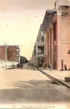
1915
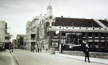
1928
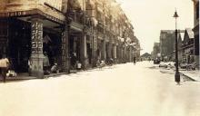
1928
Comments
Kowloon Park Drive
From The Hong Kong Report for the year 1975 (on MMIS):
In Kowloon, several projects were completed to cater for major traffic movements in the area and for traffic diversions to enable construction of the mass transit railway.
The projects included the Kowloon Park Drive joining Salisbury Road and Canton Road; the 700-metre-long Prince Edward Road—Lai Chi Kok Road flyover; and two major interchanges at Waterloo Road/Argyle Street junction and Waterloo Road/Prince Edward Road/Boundary Street junction.
There was good progress on the construction of a primary distributor route along the Kowloon foothills linking Kwun Tong and Kwai Chung, with interchanges at Choi Hung, Fung Mo, Tai Wo Ping and Pipers' Hill being brought into commission. An underpass at Nam Cheong interchange and an extension of Ching Cheung Road to Kwai Chung Road were well advanced. Works were started on the extension of Wai Yip Street to provide a second route parallel to the congested Kwun Tong Road and on the construction of a 1000-metre-long extension of Salisbury Road. Two major traffic routes on the east and west sides of Kowloon peninsula were under active planning and design.
This supports the demolition dates of the old chinese houses being around 1972 to 1974.
1914 Public Works Department's annual report
47. Principal Works of a Private Nature.
Works Completed.
.....
20 Chinese Houses K.I.L. 416, Pekin Road.
Demolition
Demolition had definitely been carried out by 1973. I am watching a film (Police Force, see here) that shot some scenes in the carpark that replaced the houses, and it was released in June 1973.