Current condition
Ruin
Date completed
Year completed is: Approximate
Condition at last visit: Ruin
Date of last visit: Jul-1996
Ref: ROB-00550
Other: Destroyed in fighting Dec 41
Photos that show this Place
1996
2025
2025
Comments
I can't find PB 300 Che Kung Temple
Dear Rob,
I have not been able to track PB 300 Che Kung Temple recently . I have used your coordinates and without success.
attached file
https://photos.app.goo.gl/JwpGq7ScTNCgcJZJ3
I look forward to hearing from you soon.
Warm regards,
Alexander
PB 300
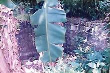
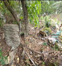
Sorry to hear you have been unable to find the PB. My notes of 22 years ago show it to be at the edge of a small village, amongst heavy vegetation, and being used as a dump. The only remains visible were part of the back wall, and one side, the rest (if any) was buried. Two paths to the village passed at the back, and on one side, joining alongside the PB.
As before, if you can get a more accurate position please let me know, so I can correct the database.
Rob
PB 300
If it's any consolation, I couldn't find PB 300 last month either. The area seemed much more heavily overgrown than my last visit 22 years ago.
Of interest; as I blundered through some thick vegetation my progress was halted by some vines. Much kicking to break the hold had no success, hardly likely as my foot was in a noose trap. Fortunately I didn't end up swinging upside down from a tree, but beware. They are out there.
Access from...?
Rob,
From where did you go uphill ? The stairs beside Richmond Villa or those behind a shrine where the man-made slope (facing north) was?
By comparing the above maps, is PB300 at the ruin #1 or 2?
PB 300
Thanks for the map/picture. Problem is, I was there in 1996, and there have obviously been a number of changes (no surprise) in the area. In the map I used, a then current 1:5000, Che Kung Temple MTR station was a Temporary Housing Area, Richmond Villa did not exist, and there was an unmarked squatter village in the area above the 40 contour line. I went up a temporary path/stairs which I presume is the path adjacent House 8. I made a half-hearted attempt to find the PB by going up the same (?) path a couple of years ago, but didn't find it.
If I were looking again, I would concentrate on the area around the short path (pointing at your ruin 1) and its intersection with the main one. Beyond that, I cant help.
Coordinates
22.37338 114.18441
50Q KK 10056 76869
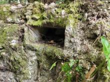
I found a "PB shaped" structure
It's facing to the NE direction
So is this the right side wall?
But this right side wall looks a bit different from other PBs
PB 300
That appears to be a PB wall, it has the grooves from the rebar which are seen on most other PB's. The PB appeared to be smaller than most others although of similar shape. The co-ordinates you gave put it in the area I expected. Thanks.
Hi Rob
Hi Rob
Thanks for the explanation. Cheers :)
Great job. How did you reach
Great job. How did you reach there, from lanes between the temple and village houses?
Hi Lo
Hi Lo
Here is the route that I used to reach PB300.
Pillbox 300
Wow, this pillbox is still in good condition even though Japanese artillery bombarded it.
Any photos of your recent
Any photos of your recent visit?
By which way did you reach there?
Noticed from the train that
Noticed from the train that there's some kind of construction site on the slope where the PB might be, can anyone give an idea if this is correct? ... cos I still haven't been to that PB.
Today's