Andrew Suddaby previously mentioned this place (www.gwulo.com/media/22223). It particularly interested me as he had heard it was where the searchlight for Pillbox No.37 had been installed. After two failed attempts to find a path to get to it, I summonsed the energy to crash through the jungle yesterday.
By now it's completely surrounded by vegetation, but back in the 80's it was still visible from afar. It's the white building just below the ridgeline and just to the left of centre in Andrew's 1981 pic.
Little Sai Wan, by Andrew Suddaby
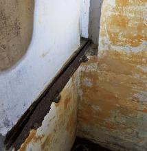
Having emerged from the rough, I found myself at what turned out to be the back door.
Rear Entrance, by gw
On the right is a toilet, then there's what looks like a water tank, then the rear entrance to the building. The door has gone, but the heavy metal door frame remains. All three, the toilet, water tank and door frame are similar to features found in British military buildings around Hong Kong.
Having seen three wild pigs shortly before arriving, a few rocks were chucked through the door to get rid of any unwanted residents. There weren't any. Inside, the building consists of a kitchen, another small room which probably housed a stove and a sink, and a large main room.
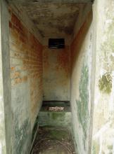
Main Room showing Front Door, by gw
At the opposite end is the large main entrance. I wonder why the building needed such a large one? Looking back.
Main Room, by gw
What's left doesn't reveal (to me) what the building had previously been used for. Features of note are the rusty metal strips that ran the length of the room above and below the windows.
The building is single storey. There's no direct access to the roof, but as the building is set into the hillside, you can get a view of it by climbing the slope at the side.
Roof, by gw
Andrew mentioned that he'd been told that the searchlight had been installed on the roof. I've no information on it either way, but there's no direct access to the roof and it's flat and without cover. Whilst a simple ladder could have solved the access issue, lack of protection from the elements and the enemy would have been more of a problem. Bearing in mind that a searchlight complementing a coastal pillbox was normally housed inside a concrete shelter for protection, positioning a searchlight inside rather than ontop of this building would appear to have been the best option.
Another difference between the arrangement here and the norm would have been the distance between the pillbox and the searchlight. Normally the crews of each communicated via a metal voice tube, but that wouldn't be possible here as the distance is too great - I'd estimate 400 meters at least. Telephone or radio comms would surely have been necessary.
Whilst I'm fairly confident this is a British military building, I can't say anything more so would be grateful for any further info on its construction date or original purpose.
As always, thanks to Andrew for all his pics and information.
Looks very much like the Collinson Anti Aircraft Searchlight (AASL) position. I don't know exactly what the metal strips were for, however the large doorway in the end leads to a sealed pathway running down to a concrete pad from where the light operated. When I saw it in 2005, besides being very overgrown then, I managed to find the terminal box for the electrical power, adjacent the pad remains. The Engine Room supplying the electrical power was situated right at the point of the (then) cape, (extreme left of Andrew's photo) but it was obviously demolished when the reclamation commenced.
The main building, besides being a storage area for the light and equipment, was also the living quarters for the searchlight crews when deployed there.
I'm indebted to Rob once more for his encyclopedic knowledge of HK's military structures and have amended the name of this "Place" to reflect the information he's provided.
Did the size of the searchlight determine the need for the large "front" door? I don't recall seeing a photo of the sort of anti-aircraft searchlights deployed in Hong Kong. Do you know of any sources?
The usage of the building as a searchlight shelter may also explain Andrew's reference mentioned above to the building being associated with a searchlight.
I followed the path that leads away from the front door. After about 50-100 meters it stopped at a clearing. Heavily overgrown with grass and low bushes, but nevertheless a clearing compared to its surroundings. It may have been the searchlight position Rob speaks of. I didn't realize its significance, so didn't search around it.
I hadn't previously heard of the Collinson Anti-Aircraft Battery. Where were the gun positions please? Does it date from just before WWII?
Once in the very early 2000s, and just possibly on the occasion when I made my aborted attempt to find the building, I climbed a flight of concrete steps that led from the camp road/path to the top of the large area where, in 1957/8 they had cut the hillside away to provide infill in the bay. At the top of this staircase I followed a narrow path (initially concrete?) that cut to the left climbing quite gradually more or less onto the ridge line. Without realising it, I was probably quite close to the building but probably above it. After a while I came across a clearing about 10 metres in diameter but I am pretty certain that it was rough ground and not concreted. At its western edge I found a small concrete block sunk into the ground. On this, somebody had scratched a date of 1960(?) while the concrete was still wet. At the time I assumed, probably quite correctly, that this was where one of a smallish aerial mast's stabilising cables had been fixed towards the end of the R.A.F.'s occupation of Little Sai Wan.. It's just possible that this might have been the clearing mentioned by Rob. Not knowing where it would take me, I then followed a very narrow, overgrown and rough path which eventually dropped down onto the lighthouse path very close to the gate. I don't know whether this adds anything to your exploration.
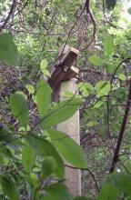
On another note, If you look at several of my photographs, including the 1981 one at the top of this thread, there's an interesting looking dome shaped 'pimple' on the skyline at,the highest point on the ridge. It does not look natural so if you fancy having another struggle through the vegetation you might find something of interest there. Of course it might have been just a large isolated bush but that in itself would have been unusual on what was in 1958 a barren hillside. Have fun. Andrew
There was, to my knowledge, no AA Battery closer to Collinson than the 3" AA Bty on Sai Wan Hill. The AASL positions were sited so as to be able to overlap the light coverage, such that aircraft could remain illuminated continuously as they flew out of range of individual lights. In 1941, there were 12 AASL positions, but only the one at WNC Gap was close, to my knowledge, to an AA Bty (WNC 3'7" AA). The ones at Braemar and Sai Wan Hill may have been, but I have been unable to determine their exact positiions.
The Collinson AASL site was built somewhere around 1933. On 13/12/41 it was shelled and damaged, but repaired. None of the AASL's were used in their primary AA role during the battle.
Good to hear from you Rob and to read your, as usual, interesting and informative comments.. Have you seen my other rather speculative comments on what must be another thread - beneath my old monochrome photograph showing the generator house down near the Point's shoreline? I had thought that these two threads were somehow one and the same and now find it tricky to keep track of the conversations - I must be doing something wrong. Hope I'm not creating confusion on the site! Best wishes, Andrew
I'm replying to your post of 23-2-2016 above. Apologies for the delay.
I'm familiar with the path you mentioned, having unsuccessfully attempted to access the AA Searchlight Shelter from it. I did however come across the clearing and the dome shaped pimple that you describe.
As you say, the concrete path starts from the Camp Road, climbs by way of steps to just below the ridgeline, then turns left, contours the slope for about 100-150 meters and ends at the clearing you described. At least two fallen metal masts, which I presume belonged to Little Sai Wan, lie in the undergrowth next to the path. On the left side of the path just before it reaches the clearing are the remains of a brick building about 5 meters in length and 3 in width - no idea what it was for and I can't make it out in your photo in my post of 21-2-2016 above. Its walls are now only about 1.5 meters tall.
The clearing at the end of the path is just a few meters to the north-west of the dome shaped pimple that is clear to see in your photo. The pimple gives a good reference point to the location of this clearing which is not the one for the AA Searchlight, which is on The Point side of the AA Searchlight Shelter.
The "pimple" is about 2 meters high. At the time I stood ontop of it I remember thinking that it didn't look natural, but at that time I hadn't equated it with the prominent dome shape seen in your photo so didn't give it much attention. If I recall correctly, the pimple is constructed of loose rock and earth. I've no idea what it was for.
I read your comments with great interest. It looks as though you and I tackled the approach to the old building in the same way. When I made my attempt in approximately 2005 the vegetation was really high and I must have missed the ruinous wall that you saw on the way to the ASSL building. I was intrigued to hear that you had found the 'pimple' to be a pile of stones about 2m high. Did you go up there recently or years ago when the vegetation was lower? In the UK there is a long tradition of building cairns like that. Most of the small mountains in the Lake District, near where I live, have them and the one on Scafell is huge. Small cairns are also traditionally used to indicate the line of the best routes across the hills - useful to be able to follow them in the frequent mists and fogs that we get around here. It's possible that this cairn at Siu Sai Wan had its origin in that tradition. Bored servicemen might have built it in pre-war days!
I came across the homepage of 367 Signals Unit that mentioned something about a military building spotted at Little Sai Wan in the 1945 aerial photo. Do you think this could be the same building we were talking about? Here is the excerpt of the article for your reference.
Freddie
aerial photographs taken by the RAF in 1945 show that a military building existed at Little Sai Wan (Hong Kong) at that time and was fairly certainly of pre-war origin. It is now believed that this was a signals station operated by the Army, most probably the Royal Signals. However, an RAF Signals presence at the site in late 1941, comprising one officer, Flt Lt. Hector (Dolly) Gray, the Signals Officer from RAF Kai Tak and several other ranks is recorded in the diary of Squadron Leader Donald Hill - see Dr Philip Aston's web-site relating to "Russell's Mathematical Tables" - entry for Saturday, 13th December 1941. The aerial photographs are now held by the Map Publications Centre, Lands Department, North Point, Hong Kong.
Based on the aerial photograph taken in 1945, it is believed that, during the period of the Japanese occupation, the site at Little Sai Wan was used by the Japanese for their own radio communications activities.
We also found this item on the floor during our last visit to the buidling. I couldn't quite make out the manufacturing date of the object but Andrew Suddaby was able to identify it as a 1950s product. Thank you for so much for his help!
Freddie
Procelain Insulator and Power Pole remains-Little Sai Wan, by Freddie
Procelain Insulator from the Power Pole - Little Sai Wan, by Freddie
The ASSL building on the ridge above Siu Sai Wan is certainly pre-war but it is not the one I made reference to in the item which I wrote for the 367 Association's website when I was the historian for that group. Prior to the war there were two instalations at Little Sai Wan. One was PB37 on a small knoll next to the beach and a bit inland from the Point with its AASL up on the ridge, the building that is still there, and with its power house down at the Point. I've just tried to insert my photograph from 1957/8 title Little Sai Wan. The Point. Old building that shows the power house at the Point, but it doesn't want to work, so you'll have to check the image out towards the end of my 1957/8 folder. Then there was a small WT transmitting and receiving station (probably run by the Army) that was situated down in the bay where R.A.F. Little Sai Wan was subsequently established after the war. It is also pretty certain that the Japanese used the same buildings, etc., during their occupation of Hong Kong. In 1957/8, when I took the photograph below, there were one, or maybe two, pre war buildings on the camp - the single storey ones just off centre in the photograph and these were originally used by the pre-war WT unit. The caption relating to this photograph in my 1957/8 folder gives more information. I understand that when PB37 was ordered to switch on its Lyon Light to dazzle the Japanese invaders at Lye Mun, PB37 was shelled causing it to be abandonned along with the AASL and Signals units, with their personnel retreating to the Stanley area. The porcelain insulator that you found on the floor of the AASL building looks very much like the ones that I remember were fitted to all the poles that carried cables around the aerial farm at Little Sai Wan in the 1950s. I suspect that if you peer into the dense vegetation below the path that used to be the camp road, you might still be able to see some of the smaller masts with their insulators still intact, although when I was last there in 2007 the creepers had almost reached the tops of the masts.
Best wishes Andrew
R.A.F. Little Sai Wan towards the gate from the N.A.A.F.I. stairs., by Andrew Suddaby
Thank you for your detailed account of the history of this site and its surrounding relics. It's so informative and fascinating. I also found the image of the power house from the picture you mentioned. Thank you so much! It really gave everyone headache to access this site through the dense undergrowth. We took the route near the seaside and brushwhack our way to the top of the ridge. I remembered we ran into something similar to a concrete underground water well along the way. Here ae some more photos I took during our visit last time. The metal strips on the wall do look like the metal tracks for the sliding window or steel shutters. But why did they need such a sliding device for the window? Apart from the one chimmey that is directly collected to the kitchen for the stove, there is no other air ducts or air vents in sight. So I guess this building was not intended for long-term accomodation for the troops or else there shoud be more than one chimmey available for air ventilation. You mentioned that the Japanese did shell the PB area. Do you think the blast marks appeared on the wall outside the building were directly linked to the shelling? It's great to know that the procelain insulator is from 1950s. I also found a power mast nearby with a different style of insulater installed. It is in a spiral shape and is very commonly seen around the hillside. I believe this is a newer model that replaced the one I posted early on.
Cheers,
Freddie
Little Sai Wan AASL Shelter - Kitchen, by Freddie
Little Sai Wan AASL Shelter - Equipment Room, by Freddie
Little Sai Wan AASL Shelter - Water Closet, by Freddie
Little Sai Wan AASL Shelter - Metal Strip for Sliding Window, by Freddie
Little Sai Wan AASL Shelter - Front Door, by Freddie
Little Sai Wan AASL Shelter - Blast Mark, by Freddie
Little Sai Wan AASL Shelter - Exterior, by Freddie
Little Sai Wan AASL Shelter - Power Mast with Porcelain Insulator , by Freddie
Your photographs are fascinating. I think that it is likely that the Japanese shelled the AASL from the Devil's Peak direction so if the shrapnel damage is on the North or West side of the building it could be from that time. Your pictures make me wish that I had tried a bit harder to get to the AASL building at Little Sai Wan but there's a reason why I didn't. When I tried to visit as many WWII bunkers and pill boxes as I could between 2001 and 2007 I was always by myself and staying in a hotel in Kowloon - the BP Internatonal one - nobody knew where I was going each morning. I only had a vague idea myself and things depended on how I got on using Tim Ko's great book, Ruins of War. I was very conscious that in some places up in the hills, I could have fallen between large boulders (especially on one occasion some big ones on the North West flank of Jardines Lookout or met a nasty snake. I was trying to find my way Northwards from JLO2 along the catchwater that the Japanese had followed. Quite a bit further on there was a place where the catchwater came to an end and I had to fight my way over those boulders and rough vegetation before finding the next section of catchwater - although I had no idea that there would be one. As I said, nobody had the faintest idea where I was and I could have lain there for ages or for ever, so I was relieved when I found the start of the next bit of catchwater. In those days I did not have a mobile phone with me. I once followed a VERY vague trail of tiny pale pink ribbon tags from above the Cheshire Home buildings at the end of the Chung Am Kok peninsula along that very rough ridge back to the inland end of the peninsula. My objective on that occasion was to see the Lewis gun position (a small concrete circle) that was just above the Cheshire Home. It was still there even with the rusty pole that had presumeably supported the Lewis gun. If my wife, back in England, had known what I was doing during those visits she would have been quite worried! It's much better that you in Hong Kong can explore in the company of others. I've got lots of photographs of the military sites that I visited during those few years but do not wish to clutter up David's website with images that any of you living in Hong Kong can so easily visit yourselves. Incidentally, on the hillside before and opposite the Cheshire Homes buildings there are at least three terraces of old military buildings (barrack rooms) that are fairly accessible. They must date back to pre WWII days when the battery was built and would be worth exploring - and you might not need a very sharp machette to get through the undergrowth that covers the higher flights of steps. I don't think there has been much 'published' about them so it could be a worthwhile exercise for you and your friends. Have fun and, once again, many thanks for sharing your photographs. Andrew
Yes, the shrapnel damage is all on the north side of the building. It is so good to hear that you used to venture into the woods to search for those war relics. I could imagine how difficult it was to locate the ruins without the help of electronic gadgets, GPS, back then. I agree with you that it would be better to head out with a group than travel alone. My friends told me what scare them the most during their exploration is the tree-felling gangs (thieves disguised as hikers to steal the incense trees) rather than wild animals. They have seen a couple of make-shift tents used by those gangs along the Gin Drinkers Line and that really scared the daylight out of them. You know what...it happened that I did take the route you reccommeneded to Chung Hom Kok this past February but only that I started out in the opposite direction. I ran into lots of old military installations along the way including the Lewis Gun AA site you mentioned. I will try to upload those images on separate thread later on. Here is the picture of the AA site which is still in very good condition.
Were the other military structures that you saw along the ridge on your walk? I'd so, I didn't see them when I was trying to find and make my way through the fairly thick vegetation. Perhaps you are referring to the ones down near the road. I was quite impressed to see how many there were - the old guardroom was very obvious and the several rows of single storey barrack rooms up some steps on the hill side were still in remarkably good condition after so long. I guess that it is possible that the British Army used the buildings even into the years just before 1997.
I didn't know that gangs of bad men went into the forest to seek and cut down incense trees. Now you have mentioned it, I recall sometimes coming across, in the years 2001 to 2007, groups of men in places where I hadn't expected to see anyone so maybe that's what they were up to. If that was the case, as I would usually have my camcorder at the ready, they might even have thought that I was trying to get evidence about their activities! On the other hand they might well have been hikers - wondering what I was doing off the usual tourist tracks of Central and Kowloon! Oh well, I'll never know!
Maybe David can answer the next question. Would it be appropriate for me to add some or all of the photographs that I took of military sites in the years 2001 to 2007 to his website? Alternatively, I could send him a DVD with them on it and he could do it if appropriate.
Keep up the good work with your explorations and best wishes. Andrew
Yes please, you'll see that several readers enjoy learning more about the military sites, so your photos will be very welcome. If you upload them in small groups of 5-10 a day as before, that works well and gives us time to digest them!
Yes, there is only one military building (the Lyon Light Shelter) on the ridge above the Leaping Dragon Trail. I never managed to hack my way through the undergrowth but there are now a few photographs of it on Gwulo, provided by a more intrepid researcher. It is shown on the maps as a yellow marker and there are several photographs accessible from that pin 'Collinson Anti-Aircraft Battery Wearchlight shelter [1933]. Andrew
Comments
Military Structure above Siu Sai Wan
Andrew Suddaby previously mentioned this place (www.gwulo.com/media/22223). It particularly interested me as he had heard it was where the searchlight for Pillbox No.37 had been installed. After two failed attempts to find a path to get to it, I summonsed the energy to crash through the jungle yesterday.
By now it's completely surrounded by vegetation, but back in the 80's it was still visible from afar. It's the white building just below the ridgeline and just to the left of centre in Andrew's 1981 pic.
Having emerged from the rough, I found myself at what turned out to be the back door.
On the right is a toilet, then there's what looks like a water tank, then the rear entrance to the building. The door has gone, but the heavy metal door frame remains. All three, the toilet, water tank and door frame are similar to features found in British military buildings around Hong Kong.
Having seen three wild pigs shortly before arriving, a few rocks were chucked through the door to get rid of any unwanted residents. There weren't any. Inside, the building consists of a kitchen, another small room which probably housed a stove and a sink, and a large main room.
At the opposite end is the large main entrance. I wonder why the building needed such a large one? Looking back.
What's left doesn't reveal (to me) what the building had previously been used for. Features of note are the rusty metal strips that ran the length of the room above and below the windows.
The building is single storey. There's no direct access to the roof, but as the building is set into the hillside, you can get a view of it by climbing the slope at the side.
Andrew mentioned that he'd been told that the searchlight had been installed on the roof. I've no information on it either way, but there's no direct access to the roof and it's flat and without cover. Whilst a simple ladder could have solved the access issue, lack of protection from the elements and the enemy would have been more of a problem. Bearing in mind that a searchlight complementing a coastal pillbox was normally housed inside a concrete shelter for protection, positioning a searchlight inside rather than ontop of this building would appear to have been the best option.
Another difference between the arrangement here and the norm would have been the distance between the pillbox and the searchlight. Normally the crews of each communicated via a metal voice tube, but that wouldn't be possible here as the distance is too great - I'd estimate 400 meters at least. Telephone or radio comms would surely have been necessary.
Whilst I'm fairly confident this is a British military building, I can't say anything more so would be grateful for any further info on its construction date or original purpose.
As always, thanks to Andrew for all his pics and information.
Military Structure SSW
Looks very much like the Collinson Anti Aircraft Searchlight (AASL) position. I don't know exactly what the metal strips were for, however the large doorway in the end leads to a sealed pathway running down to a concrete pad from where the light operated. When I saw it in 2005, besides being very overgrown then, I managed to find the terminal box for the electrical power, adjacent the pad remains. The Engine Room supplying the electrical power was situated right at the point of the (then) cape, (extreme left of Andrew's photo) but it was obviously demolished when the reclamation commenced.
The main building, besides being a storage area for the light and equipment, was also the living quarters for the searchlight crews when deployed there.
Mount Collinson Anti-Aircraft Battery Searchlight Shelter
I'm indebted to Rob once more for his encyclopedic knowledge of HK's military structures and have amended the name of this "Place" to reflect the information he's provided.
Did the size of the searchlight determine the need for the large "front" door? I don't recall seeing a photo of the sort of anti-aircraft searchlights deployed in Hong Kong. Do you know of any sources?
The usage of the building as a searchlight shelter may also explain Andrew's reference mentioned above to the building being associated with a searchlight.
I followed the path that leads away from the front door. After about 50-100 meters it stopped at a clearing. Heavily overgrown with grass and low bushes, but nevertheless a clearing compared to its surroundings. It may have been the searchlight position Rob speaks of. I didn't realize its significance, so didn't search around it.
I hadn't previously heard of the Collinson Anti-Aircraft Battery. Where were the gun positions please? Does it date from just before WWII?
Clearin.
Hi GW
Once in the very early 2000s, and just possibly on the occasion when I made my aborted attempt to find the building, I climbed a flight of concrete steps that led from the camp road/path to the top of the large area where, in 1957/8 they had cut the hillside away to provide infill in the bay. At the top of this staircase I followed a narrow path (initially concrete?) that cut to the left climbing quite gradually more or less onto the ridge line. Without realising it, I was probably quite close to the building but probably above it. After a while I came across a clearing about 10 metres in diameter but I am pretty certain that it was rough ground and not concreted. At its western edge I found a small concrete block sunk into the ground. On this, somebody had scratched a date of 1960(?) while the concrete was still wet. At the time I assumed, probably quite correctly, that this was where one of a smallish aerial mast's stabilising cables had been fixed towards the end of the R.A.F.'s occupation of Little Sai Wan.. It's just possible that this might have been the clearing mentioned by Rob. Not knowing where it would take me, I then followed a very narrow, overgrown and rough path which eventually dropped down onto the lighthouse path very close to the gate. I don't know whether this adds anything to your exploration.
On another note, If you look at several of my photographs, including the 1981 one at the top of this thread, there's an interesting looking dome shaped 'pimple' on the skyline at,the highest point on the ridge. It does not look natural so if you fancy having another struggle through the vegetation you might find something of interest there. Of course it might have been just a large isolated bush but that in itself would have been unusual on what was in 1958 a barren hillside. Have fun. Andrew
Collinson AASL
There was, to my knowledge, no AA Battery closer to Collinson than the 3" AA Bty on Sai Wan Hill. The AASL positions were sited so as to be able to overlap the light coverage, such that aircraft could remain illuminated continuously as they flew out of range of individual lights. In 1941, there were 12 AASL positions, but only the one at WNC Gap was close, to my knowledge, to an AA Bty (WNC 3'7" AA). The ones at Braemar and Sai Wan Hill may have been, but I have been unable to determine their exact positiions.
The Collinson AASL site was built somewhere around 1933. On 13/12/41 it was shelled and damaged, but repaired. None of the AASL's were used in their primary AA role during the battle.
Good to hear from you Rob and
Good to hear from you Rob and to read your, as usual, interesting and informative comments.. Have you seen my other rather speculative comments on what must be another thread - beneath my old monochrome photograph showing the generator house down near the Point's shoreline? I had thought that these two threads were somehow one and the same and now find it tricky to keep track of the conversations - I must be doing something wrong. Hope I'm not creating confusion on the site! Best wishes, Andrew
Collinson AA Battery Searchlight Shelter
Collinson AA Battery Searchlight Shelter
Hi Andrew,
I'm replying to your post of 23-2-2016 above. Apologies for the delay.
I'm familiar with the path you mentioned, having unsuccessfully attempted to access the AA Searchlight Shelter from it. I did however come across the clearing and the dome shaped pimple that you describe.
As you say, the concrete path starts from the Camp Road, climbs by way of steps to just below the ridgeline, then turns left, contours the slope for about 100-150 meters and ends at the clearing you described. At least two fallen metal masts, which I presume belonged to Little Sai Wan, lie in the undergrowth next to the path. On the left side of the path just before it reaches the clearing are the remains of a brick building about 5 meters in length and 3 in width - no idea what it was for and I can't make it out in your photo in my post of 21-2-2016 above. Its walls are now only about 1.5 meters tall.
The clearing at the end of the path is just a few meters to the north-west of the dome shaped pimple that is clear to see in your photo. The pimple gives a good reference point to the location of this clearing which is not the one for the AA Searchlight, which is on The Point side of the AA Searchlight Shelter.
The "pimple" is about 2 meters high. At the time I stood ontop of it I remember thinking that it didn't look natural, but at that time I hadn't equated it with the prominent dome shape seen in your photo so didn't give it much attention. If I recall correctly, the pimple is constructed of loose rock and earth. I've no idea what it was for.
AASL site Siu Sai Wan
Hi GW
I read your comments with great interest. It looks as though you and I tackled the approach to the old building in the same way. When I made my attempt in approximately 2005 the vegetation was really high and I must have missed the ruinous wall that you saw on the way to the ASSL building. I was intrigued to hear that you had found the 'pimple' to be a pile of stones about 2m high. Did you go up there recently or years ago when the vegetation was lower? In the UK there is a long tradition of building cairns like that. Most of the small mountains in the Lake District, near where I live, have them and the one on Scafell is huge. Small cairns are also traditionally used to indicate the line of the best routes across the hills - useful to be able to follow them in the frequent mists and fogs that we get around here. It's possible that this cairn at Siu Sai Wan had its origin in that tradition. Bored servicemen might have built it in pre-war days!
Best wishes Andrew
Additional notes from Rob
[Admin: I've combined the information from Rob's Place to this page, and deleted the duplicate. He wrote:]
Collinson AASL Storeroom, Cape Collinson [1933- ]
Year completed is: Approximate
Condition at last visit: Intact
Date of last visit: Jun-2005
Ref: ROB-00027
Other:
Signals Station at Little Sai Wan???
Hi Rob,
I came across the homepage of 367 Signals Unit that mentioned something about a military building spotted at Little Sai Wan in the 1945 aerial photo. Do you think this could be the same building we were talking about? Here is the excerpt of the article for your reference.
Freddie
Old Procelain Insulator of the power pole found on the floor
Hi,
We also found this item on the floor during our last visit to the buidling. I couldn't quite make out the manufacturing date of the object but Andrew Suddaby was able to identify it as a 1950s product. Thank you for so much for his help!
Freddie
Pre War building at Little Sai Wan
Hi Freddie
The ASSL building on the ridge above Siu Sai Wan is certainly pre-war but it is not the one I made reference to in the item which I wrote for the 367 Association's website when I was the historian for that group. Prior to the war there were two instalations at Little Sai Wan. One was PB37 on a small knoll next to the beach and a bit inland from the Point with its AASL up on the ridge, the building that is still there, and with its power house down at the Point. I've just tried to insert my photograph from 1957/8 title Little Sai Wan. The Point. Old building that shows the power house at the Point, but it doesn't want to work, so you'll have to check the image out towards the end of my 1957/8 folder. Then there was a small WT transmitting and receiving station (probably run by the Army) that was situated down in the bay where R.A.F. Little Sai Wan was subsequently established after the war. It is also pretty certain that the Japanese used the same buildings, etc., during their occupation of Hong Kong. In 1957/8, when I took the photograph below, there were one, or maybe two, pre war buildings on the camp - the single storey ones just off centre in the photograph and these were originally used by the pre-war WT unit. The caption relating to this photograph in my 1957/8 folder gives more information. I understand that when PB37 was ordered to switch on its Lyon Light to dazzle the Japanese invaders at Lye Mun, PB37 was shelled causing it to be abandonned along with the AASL and Signals units, with their personnel retreating to the Stanley area. The porcelain insulator that you found on the floor of the AASL building looks very much like the ones that I remember were fitted to all the poles that carried cables around the aerial farm at Little Sai Wan in the 1950s. I suspect that if you peer into the dense vegetation below the path that used to be the camp road, you might still be able to see some of the smaller masts with their insulators still intact, although when I was last there in 2007 the creepers had almost reached the tops of the masts.
Best wishes Andrew
Little Sai Wan AASL Shelter
Hi Andrew,
Thank you for your detailed account of the history of this site and its surrounding relics. It's so informative and fascinating. I also found the image of the power house from the picture you mentioned. Thank you so much! It really gave everyone headache to access this site through the dense undergrowth. We took the route near the seaside and brushwhack our way to the top of the ridge. I remembered we ran into something similar to a concrete underground water well along the way. Here ae some more photos I took during our visit last time. The metal strips on the wall do look like the metal tracks for the sliding window or steel shutters. But why did they need such a sliding device for the window? Apart from the one chimmey that is directly collected to the kitchen for the stove, there is no other air ducts or air vents in sight. So I guess this building was not intended for long-term accomodation for the troops or else there shoud be more than one chimmey available for air ventilation. You mentioned that the Japanese did shell the PB area. Do you think the blast marks appeared on the wall outside the building were directly linked to the shelling? It's great to know that the procelain insulator is from 1950s. I also found a power mast nearby with a different style of insulater installed. It is in a spiral shape and is very commonly seen around the hillside. I believe this is a newer model that replaced the one I posted early on.
Cheers,
Freddie
Hi Freddie
Hi Freddie
Your photographs are fascinating. I think that it is likely that the Japanese shelled the AASL from the Devil's Peak direction so if the shrapnel damage is on the North or West side of the building it could be from that time. Your pictures make me wish that I had tried a bit harder to get to the AASL building at Little Sai Wan but there's a reason why I didn't. When I tried to visit as many WWII bunkers and pill boxes as I could between 2001 and 2007 I was always by myself and staying in a hotel in Kowloon - the BP Internatonal one - nobody knew where I was going each morning. I only had a vague idea myself and things depended on how I got on using Tim Ko's great book, Ruins of War. I was very conscious that in some places up in the hills, I could have fallen between large boulders (especially on one occasion some big ones on the North West flank of Jardines Lookout or met a nasty snake. I was trying to find my way Northwards from JLO2 along the catchwater that the Japanese had followed. Quite a bit further on there was a place where the catchwater came to an end and I had to fight my way over those boulders and rough vegetation before finding the next section of catchwater - although I had no idea that there would be one. As I said, nobody had the faintest idea where I was and I could have lain there for ages or for ever, so I was relieved when I found the start of the next bit of catchwater. In those days I did not have a mobile phone with me. I once followed a VERY vague trail of tiny pale pink ribbon tags from above the Cheshire Home buildings at the end of the Chung Am Kok peninsula along that very rough ridge back to the inland end of the peninsula. My objective on that occasion was to see the Lewis gun position (a small concrete circle) that was just above the Cheshire Home. It was still there even with the rusty pole that had presumeably supported the Lewis gun. If my wife, back in England, had known what I was doing during those visits she would have been quite worried! It's much better that you in Hong Kong can explore in the company of others. I've got lots of photographs of the military sites that I visited during those few years but do not wish to clutter up David's website with images that any of you living in Hong Kong can so easily visit yourselves. Incidentally, on the hillside before and opposite the Cheshire Homes buildings there are at least three terraces of old military buildings (barrack rooms) that are fairly accessible. They must date back to pre WWII days when the battery was built and would be worth exploring - and you might not need a very sharp machette to get through the undergrowth that covers the higher flights of steps. I don't think there has been much 'published' about them so it could be a worthwhile exercise for you and your friends. Have fun and, once again, many thanks for sharing your photographs. Andrew
Chung Hom Kok Military Sites
Hi Andrew,
Yes, the shrapnel damage is all on the north side of the building. It is so good to hear that you used to venture into the woods to search for those war relics. I could imagine how difficult it was to locate the ruins without the help of electronic gadgets, GPS, back then. I agree with you that it would be better to head out with a group than travel alone. My friends told me what scare them the most during their exploration is the tree-felling gangs (thieves disguised as hikers to steal the incense trees) rather than wild animals. They have seen a couple of make-shift tents used by those gangs along the Gin Drinkers Line and that really scared the daylight out of them. You know what...it happened that I did take the route you reccommeneded to Chung Hom Kok this past February but only that I started out in the opposite direction. I ran into lots of old military installations along the way including the Lewis Gun AA site you mentioned. I will try to upload those images on separate thread later on. Here is the picture of the AA site which is still in very good condition.
Best wishes, Freddie
Hi Freddie
Hi Freddie
Were the other military structures that you saw along the ridge on your walk? I'd so, I didn't see them when I was trying to find and make my way through the fairly thick vegetation. Perhaps you are referring to the ones down near the road. I was quite impressed to see how many there were - the old guardroom was very obvious and the several rows of single storey barrack rooms up some steps on the hill side were still in remarkably good condition after so long. I guess that it is possible that the British Army used the buildings even into the years just before 1997.
I didn't know that gangs of bad men went into the forest to seek and cut down incense trees. Now you have mentioned it, I recall sometimes coming across, in the years 2001 to 2007, groups of men in places where I hadn't expected to see anyone so maybe that's what they were up to. If that was the case, as I would usually have my camcorder at the ready, they might even have thought that I was trying to get evidence about their activities! On the other hand they might well have been hikers - wondering what I was doing off the usual tourist tracks of Central and Kowloon! Oh well, I'll never know!
Maybe David can answer the next question. Would it be appropriate for me to add some or all of the photographs that I took of military sites in the years 2001 to 2007 to his website? Alternatively, I could send him a DVD with them on it and he could do it if appropriate.
Keep up the good work with your explorations and best wishes. Andrew
re: photos of military sites, 2001 to 2007
Hi Andrew,
Yes please, you'll see that several readers enjoy learning more about the military sites, so your photos will be very welcome. If you upload them in small groups of 5-10 a day as before, that works well and gives us time to digest them!
Regards, David
Makeshift arms factory in a searchlight shelter
Is this the shelter used as a 'makeshift arms factory for producing home-made bullets and explosives' that led to arrests on 26th March 2020?
Report on the South China Morning Post web site:
Four men arrested as Hong Kong police uncover site containing materials for making ammunition and explosives
Lyon Light shelter Siu Sai Wan
Yes, there is only one military building (the Lyon Light Shelter) on the ridge above the Leaping Dragon Trail. I never managed to hack my way through the undergrowth but there are now a few photographs of it on Gwulo, provided by a more intrepid researcher. It is shown on the maps as a yellow marker and there are several photographs accessible from that pin 'Collinson Anti-Aircraft Battery Wearchlight shelter [1933]. Andrew
Can't read your article as I
Can't read your article as I am not a member of SCMP, but I found a clip in Cantonese ... at least we can have a look at the building.
https://www.facebook.com/RTHKVNEWS/videos/%E5%B0%8F%E8%A5%BF%E7%81%A3%E…