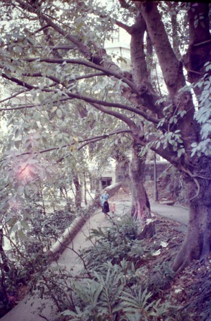
I noticed that my Mum had put a caption against this slide number saying 'off to church'. This suggests the pathway must be somewhere between MacDonnell Road and St John's Cathedral.
I have posted two other photos that may be part of the same or similar route.
Date picture taken
1957
Gallery
Comments
Wanchai
It may have changed since the 50s but this reminds me of the zigzag path that links Ship Street area with Kennedy Road close to Nam Koo Terrace and the old Chitose Hotel building.
Thanks very much, I have no
Thanks very much, I have no idea but have a few photos on these sort of paths.
Path
I think this is towards the bottom of Battery Path leading to Queen's Road Central, approached by passing St Johns Cathedral and walking down.
Location of path
Thank you very much
Location of path
Dibsey - I used to walk down there so frequently, it was lovely to see it as it was in my youth again!
I'm so glad you enjoyed the
I'm so glad you enjoyed the photo. I was only 3 when we went to Hong Kong and so my memories are mainly second hand. The help provided by people such as yourself through this wonderful website has helped me to piece information together and gain a much better insight into our lives there. My Mum helped with the Sunday School at the Cathedral so I expect that we often walked that way.
Location
Well well! My Mum ran the kindergarten at St John's Cathedral! Thelma Miller. So did your Mother help out my mother I wonder?
x
We were in Hong Kong between
We were in Hong Kong between 1956-1958, does that coincide with you?. As we are writing I am looking through a copy of the 'St John's review' that my Mum kept with various other items. Her name was Eleanor Bullock. She also kept a Christmas card from Joan Temple, thanking her for her work in the Sunday school.
Best wishes,
Chris (Dibsy is what my Mum and Dad used to call me at that time)
Re: Photo Location
Would like to think it is/was Battery Path but can't figure out for now the building behind.
Battery path
When my family first emigrated to Hong Kong in 1956 my Dad worked in a small two room office just a little up Battery Path. It was the Quantity Surveying office and it contained one senior QS, one clerk, one dog and then included my Dad. People were fleeing China at that point and the government recognised the need to build resettlement apartments to house them, hence my Dad's appointment. I believe this small office, with its ceiling fans is or was the building in the picture!
Hillside path name
Just behind the former Knightsbridge Court off Barker Road - the path from the tennis courts down to May Road.
This is not battery path as
This is not battery path as there is nowhere there with a switchback shown in the picture.The only possibility I could find is the path down from Upper Albert Road to Glenealy pre flyover construction which would make the white building Alford House, however I am not convinced that this is the correct location. Chris you said you had other similar shots it would bw helpful if you could post them to give more clues. The white building behind the trees looks to be five or six stories. There is also what looks to be a lot marker in the wall between tree and lamppost, I am not sure how much details the picture has but if could be scanned at a higher resolution to read the number on the lot marker it would tell us exactly where the photo was taken.
Re: Photo
Some of the photos posted by Chris were horizontally flipped. So not sure about this one. May be Glenealy below Caine Road e.g. here but not able to confirm.
The photo is interesting as there are not many six storey buildings next to a steep path.
Re: hair pin turns
Hi There,
I do not believe that is Battery Path as there is no such turns there. That doesn't look like Chatham Path either. But foot paths like this ought to be on the Island somewhere, probably on the Northern slope. Just the image could not provide sufficient visual clues for us.
T
Path between Upper Albert Road and Glenealy Road
Actually I do find the steep snaking path between Upper Albert Road and Glenealy Road to be the most credible location. It is on the way to St John's Cathedral. The topography and orientation of the path fits. The building behind would be 6 stories high (as is Alford House).
I have included a cropped image from the Hong Kong and Kowloon Survey sheets from 1955. This is unfortunately the maximum resolution:
The red dot is the location of Dibsy and Mum. The green dot would be the location of the photographer. Interestingly there is an 'X' exactly where the lot marker is in the photo (please see the original link!). There are other 'X's at multiple places in the Survey Sheets and I wonder if they are location of lot markers.
Alford House was built in 1955 and was and still is 6 stories high. Just a shame there is too much foliage in the original photo to give a definite ID to the building.
path
The path seems a bit too curvy on the map to match the one on the photo. There is a more acutely angled path that leads from MacDonnell Road down onto Kennedy Road that used to pass "The Hermitage". It's still visible on the 1965.1 mapand includes intermittant steps that appear to be shown on the image.
Path between Upper Albert Road and Glenealy Road
Alford House has an entrance at the hairpin bend on the path connecting Glenealy and Upper Albert Road. The bend is at the ground floor of the building, which still can be seen today (photo below) . So it's not easy to match that location with what's shown in Chris' photo.
I think this actually may be…
I think this actually may be Battery Path, but the part between Upper and Lower Albert Road rather than the lower part leading to Queens Road Central. It is a plausible route leading to St Johns from MacDonnell Road and the little dead end path leading to a wall still exists today. The building behind would the US consulate, completed in 1957 so right around this photo date. The lamp post is also in the correct place. The path has been extensively rebuilt for a substation and does not exactly match the photo but generally its a pretty good fit for the location
Battery Path
The closest available maps on hkmaps appear to be 1957.1 and 1960. Both of which show a curved path that doesn't match this more angular turn/switchback.
Also, on both maps there is an obvious dead end to the path at the apex of the turn - perhaps where a branch to the path was blocked off when the consulate was built (or whatever preceded it). It's still there today marked by 3 bollards. There is also a set of stone steps on both maps that are still there today and which I would expect to see in the image but none of these elements seem to be present, so I don't think it is that particular section either.
Re: 1957.1 and 1960 Maps
Noted the former Central Hospital on Lower Albert Road appears on the 1957.1 map.
Horizontally flipped the original slide. Would the photo show the "V end" of Albert Path nearest to Central Hospital when looking at the 1960 map (before the construction of steps) on hkmaps?
Approaching the "V end" on Google Street View
Looks right to me. I flipped…
I think thats right. I flipped the photo and the stonework layout/colour on the end of the wall matches the current layout on google street view.
Albert Path
nice find Moddsey - yes, there is a dark coloured stone in the wall that can still be seen in the current Streetview.
Re: Albert Path?
Hi There,
I still think it is a bit off. The present day Albert Path are steps at the lower end. Might need some other older photos from Lower Albert Road for reference.
T
Albert Path
The section of the path in the original image is now a dead end. The higher part of the path on the left (in herostratus' flipped version) is no longer there/used.
There is an exact match to the brickwork in the remaining wall to that in the original which pretty much confirms the location in my opinion.
Re: Albert Path?
Hi Phil,
Maybe that is a good reason to have a look on-site when I am in the area next time. I could not recall if I had ever walked along the path before.
T
Albert Path
Yes, unfortunately the Street view imagery only captures the area from a distance so you have to zoom in to see the dark stone mentioned above. It would definitely be helpful if someone could take a close up.
Re: Albert Path
The changes made to Albert Path can be seen in the 1970 map. There were no steps as far as I note at mid-path in the 1960 map.
Recent Photo of Albert Path
A recent photo of Albert Path taken by Tngan. Thanks for taking the time.
Coincidence or not but zooming-in, the dark-coloured stone appears in the stonework of the remaining wall.
Defining Albert Path
Today's Government Gazette defines Albert Path as the stepped footpath commencing at its junction with Lower Albert Road east of the Central Hospital running generally in a southerly direction, crossing Upper Albert Road between the Church Guest House and Government House and terminating at its junction with Albany Road.
Source: China Mail 27 September 1957