The labels are in Chinese. Number 1 means shatin floating restaurant. Number 2 means Sheng Wo Che, Ha Wo Che between sha Tin Wai road and Fo Tan Road. It is probably the earliest location before any major land reclamation took place.
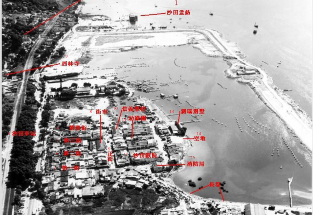
The area was called 沙田舊墟 or Shatin old village which existed approximately from 1954 to 1979 when it was demolished to make way for the New Town Plaza.
English labels:
1 shatin floating restaurant
2 sai lam temple
3 shatin station
4 fourth street
5 third street
6 second street
7 first street
8 market
9 centre street
10 shun yee school
11 kindergarden
12 shatin theater
13 lau shui villa
14 clearing
15 fire station
1970 map:
Date picture taken
1972 (year is approximate)
Shows place(s)
Comments
Statin
Photo probably late 1960s?
labels
The area was called 沙田舊墟 or Shatin old village which existed approximately from 1954 to 1979 when it was demolished to make way for the New Town Plaza.
1958 shatin old village from train
1958 shatin old village viewed from train when the train was approaching the Shatin station.
old shatin village New Market street
This is a photo of New Market Street in Old Shatin Village. The fourth shop on the right was a restaurant called Chung Yuen restaurant (松苑菜館). The address was Shatin New Market Street (新市街) given in 1967 年香港年鑑. Where exactly was the street in the above air photo? Is it located in the market?
date of photo
The shatin bypass road was still under construction but the construction of Lik Yuen estate north of the shatin old town hasn't started yet. A good estimate would be between 1972 and 1973. The HKmaps.hk 1973 map indicates the part between bypass road and old town was already reclaimed in 1973.