Just by chance I found on YouTube a film from 1949 titled Hong Kong Under The Red Shadow Australia's Northern Frontier (1949)
At the end of this short (2:54) film this boundary stone is shown close to Man Kam To bridge. Update: it's located at Sha Tau Kok,
Date picture taken
1949
Gallery
Shows place(s)
Comments
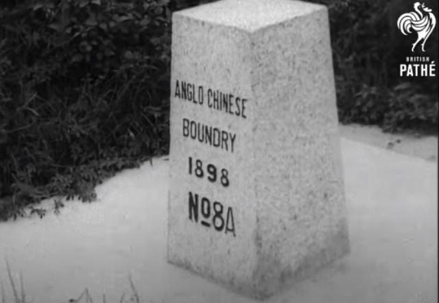
Anglo-Chinese Boundary Stone No. 8A
Thank you posting the screenshot of the No. 8A Boundary Stone. The original No. 8 Boundary Stone stood on the stream bed that divided the border but later became displaced due to flooding. Two new stones numbered 8A and 8B were later erected close to the original border marker on each side of the stream bank in April 1948. Further information here
No. 8A stone's location
Hi Klaus,
The film is a bit misleading - the final clip with the 8A stone was filmed at a different location from the previous clip of the Man Kam To bridge. (Although both clips show a bridge, they're different bridges.)
So the Place for this photo is either the general "Boundary Stones along Chung-Ying Street [????- ]" or a new Place for this stone's location.
Regards, David
No 8a Boundary Stone
Hi David, to be honest, I do not know the correct place for the stone. Moddsey's post indicate that 8A was at Sha Tau Kok rather than at Man Kam To.
So it might belong to the row of stones along Chung-Ying Street, see this photo from 1949:
But where is the "stream" mentioned in the newspaper clip.
Regards, Klaus
Re: Newspaper Clipping on Sha Tau Kok
The newspaper clipping from 1948 mentioning boundary stones 1 to 8 refer to Sha Tau Kok.
The historical northern border can be read here . Noted a typo in the linked reference - "and then proceeds until it comes to the bed of a wide stream which is at present dry. It was agreed that the boundary should follow the centre of the river bed."
Boundary Stone No. 8A and the shallow creek and bridge can be viewed here
Re: 8A boundary stone
Thank you for these extra information. The shallow creek and the pedestrian bridge on the linked Harrison Forman photo can also be seen at the end (2:52) of the 1949 video.