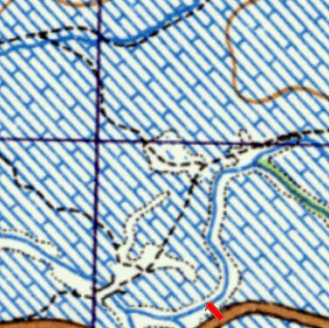
Old Timer and I have been worrying about the location of the photograph that I took in 1958 of a river bend, children fishing and some buffalo hides drying on frames. In brief, we have used the 1952 map to search along the road in the area roughly between Yuen Long and somewhere to the East of Sek Kong. My memory is of taking two photographs (now stitched together) from the main road and looking to the North. I have added a red arrow where I believe that I probably stood.

As mentioned previously, an old lady in Yuen Long told me in c2005 that the river had been completely changed. There is only one spot on the map that seems to fit the bill and that is just to the NE of the Sek Kong camp. The river bends into the road, there is a small footbridge on the left and the slightly hilly ground, while not built on as it was in 1958 looks to be correct. Below is a Google Street View image of the same place. My concern is that memory tells me that the road was straight where I took the photographs, but I could be wrong on that point as it approaches the river bend at an angle on the Street View image and the 1952 map! Has anyone else got any thoughts? I'll add a pin if we can solve this problem.
it has just struck me that because I have stitched two images together the resulting image above might show the bend as being much tighter than it really was. If so, it would match the map's river bend better.
Comments
River Bend in New Territories
Andrew’s photo reminds me of my childhood days while visiting New Territories. I decided to find this site by comparing its geographic features with those in the 1952 contour map. Along the way Andrew’s advice helped rarrow my list along the main roads (and some not so main) starting eastward from Pak Yuen Camp (today’s Chung Uk Tsuen Stop) to Yuen Long, Kam Tin, Tai Po and Sheung Shui. When all my candidate sites have been eliminated, Andrew suggested one site which we now believe fits this photo.
Key features in the photo: rural setting, a small river with a bend, and several children playing by the water. The light clothings suggest this was summer, but the sun’s shadow cannot tell the camera’s direction. The river makes a sharp about 90-degree turn (more on this later) but its orientation on the map is not known. Beyond the footbridge, the river appears to turns to the left to run alongside a farm road. The river in the foreground widens to the right but this is unlikely to show on the 1952 map. While the two arms of the river look similar in size, this spot might have a third branch running to/from the left of the photo. The size indicates its drainage area is not large, however, the watermarks and bank erosion suggest it gets the occasional large flows.
The photo shows a small portion of a ridgeline (one hill? Or two hills?) at an unknown distance. The local topography is fairly flat and stream water level is calm with no rapids or cascades. The camera is higher than the ground and given the picture quality, the photo was likely taken from a high path/road, a stopped vehicle.
Next, I looked for an stream with L-shape and T-shape in any orientation with the features discussed above. With Andrew’s one more suggestion (credit goes to him), I believe we have found a match.
On the 1952 map (shown above on main page), it shows the river in the foreground flowing from right (east) to left (west), and after flowing past the footbridge, it turns to the northwest as the photo appears to show. It also shows two small branches flowing from the south and beneath the road before joining the river in the foreground. For discussing purposes here, I call them the west branch and east branch. The initial pin (red arrow) was placed east of both their junctions. The correct spot for the pin is between these two lower arms. The 90-degree bend needs an explanation. I believe when the 1952 map was drawn, the junction point for the west branch was placed too far north compared to reality, hence my failure to include it as a candidate.
And those nearby houses in the photo, the 1952 map idenifies it as settlement area so it fits.
Finally, that small faint ridgeline in the photo could be the same as the overlapping ridgeline we can see today in Andrew’s Google photo - https://gwulo.com/atom/33669
Regards, Peter
another contender
there looks to be another contender immediately opposite the main entrance. It shows a tighter curve on the 1950's map, but looking at the area today, there are signs that a small water course once passed right next to the road.
Phil
Thank you Peter for your
Thank you Peter for your excellent summary of what has been a complicated email conversation between us, and thank you Phil for noting the very similar river bend that was more or less opposite to the main gate into the Sek Kong Army and R.A.F. camp. I had seen that but tend to eliminate it for two reasons. Firstly the map does not show a footbridge across the river to the NW of that location (that could of course have been built after the map was made), and there is no higher/dry ground within the bend of the river. My other reason is that I have always remembered that the photograph was taken more or less in open countryside and I think that I would have noticed, and possibly remembered, the Sek Kong gate. However, as we all know memory is a very fickle thing, especially when it concerns a very brief visit to anywhere! I have just remembered another photograph in my 1981 gallery that I took in the same place that shows just the left hand side of the bend and which also shows some hills in the background. Does that help? I have a feeling that when my wife and I were there in 1981, we were out in the open contryside and not close to the Sek Kong camp:
If, as seems possible, we are in the right general area, perhaps some of the Gwulo family who were stationed at Sek Kong might be able to help - especially if they were there around 1958, when I took the original photographs. Seeing those buffalo hides would be very unusual for any of us. Andrew
I have just checked both the possible bends out on the 1939 map and the bend furthest away from the Sek Kong gate looks much more likely. A foot bridge is definitely shown in the place corresponding with my photograph and, while the road was not completed in 1939, I suspect that it was eventually extended due East, losing the long bend in the narrow track shown on the 1939 map. That would reinforce my memory of the road being straight in 1958 and would also mean that something like open countryside was around me when I took the twophotographs. Andrew
I have now added a pin onto the 1952 map and Google Earth.