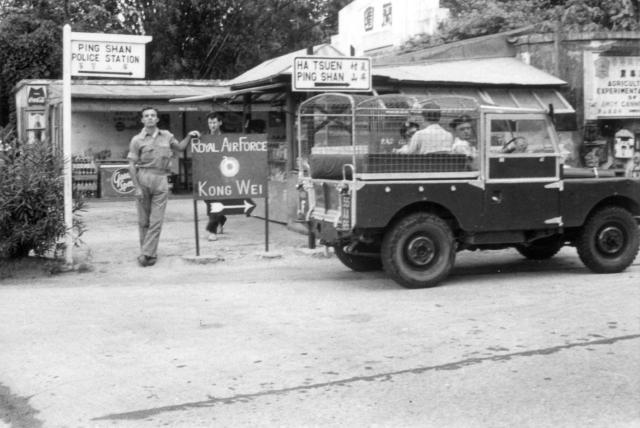
This small shop at the junction of the Castle Peak Road and the Ping Ha Road was a likely place to stop and buy refreshments on the way to work. (Andrew S)
Date picture taken
1960s
Gallery
Shows place(s)
Comments
Year 1949 Hong Kong…
Year 1949 Hong Kong government announced the expropriation of Ping shan Orchid Garden Villa 蘭園 as military use
Hi terewong,Thank you for…
Hi terewong,
Thank you for the contribution. The photograph that was taken by Gordon Innes shows a shop at the turn off on the Castle Peak Road, to the North West of what appears on the Google Earth imagery to be the Ping Shan Orchid garden complex. The site of Gordon's photograph is now very close to the South East a corner of what looks like the Century Theatre.
The proposed Ping Shan airfield (I don't think it was ever built) and the other R.A.F. installations were further North on the Ping Han road and mainly on the West side of the river (now canalised). A large circular area ringed by trees or bushes is on the site of one of the R.A.F. D.F huts. This image has always intrigued me as it is in the correct place but looks to be much larger than the original perimeter fencing around the hut. All these places are visible on page 144/5 of the excellent book of 1964 aerial photographs that was published in 2007, and I have placed pins for 4 of these onto the Gwulo map. I hope that I am not misunderstanding you!
Correction, the R.A.F. site to which I referred, and which features in several of the sub galleries in the 367 Association gallery, was actually called Kong Wei (being fairly close to what I believe was a village by that name. An earlier R.A.F. site might well have been where you suggested to the south of the Castle Peak Road where the Orchard Garden complex now is. My own confusion stems from the fact that I never visited either the Kong Wei or Ping Shan sites and I relied on the somewhat vague memories of my older colleagues. Apologies if I have caused any confusion. Regards, Andrew