On Flickr, two proposals for the location are made:
1. Johnston Road (looking west) near Southorn Playgound (which would be at the right hand side). The white building would then be The Pawn at 62 Johnston Road.
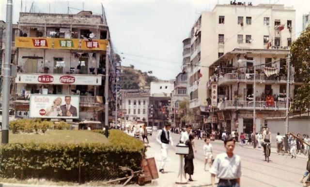
2. I would say this was where Chai Wan road meets Shau Kei Wan Road and Aldrich Street.
Any clue where it is?
Identified as Shau Kei Wan Road at the junction with Aldrich Street. (Thanks)
Source: This image came from Flickr, see https://flickr.com/photo.gne?id=29907496727
Date picture taken
1960s
Gallery
Shows place(s)
Comments
Re: Sai Wan Ho?
Hi there,
I am more inclined to think it was somewhere in Sai Wan Ho, the phographer was facing East-ish, maybe closer to present day Hoi An\Hoi Ning streets, along Shau Kei Wan Road,
Unfortunately not much of the shop signs could be read or we might have more clues.
T
Re:Sai Wan Ho?
Hi There,
After viewing it again this morning, my previosu comment did not add up as there shoudl be no hill if the photographer was standing closer towards Sai Wan Ho. I tend to agreed it's closer to Chai Wan Road. We just need some old photos of the area and time period for a match.
T
1960 Unknown streetscene - Chai Wan road meets Shau Kei Wan Road
Yes, this is Chai Wan Road meets Shau Ki Wan Road
All buildings in the photo had been demolished, however able to find a photo of 1964,
the green on your photo's lower left meet the 1964 photo, also the 2 poles for the tram.
https://post76.hk/forum.php?mod=attachment&aid=MjQyMjg4fDMwZmIyNTQ2fDE1…
The wall on the right should be the of Canossa College whihc moved to Quarry Bay.
This is indeed where Chai Wan Road meets Shau Ki Wan Road
I was a pupil of Salasian School in the vicinity in 1963, so I remember this scene. However, Chai Wan Road wasn't called "Chai Wan Road" at that time. It was called "Island Road (香島道)," so Salasian School was at 16 Island Road. Further up Island Road, near the access road to the Lei Yue Mun Barracks, was "Island Place (藹寧園)," named after the road name. It was build under the then "housing scheme" for civil servants and was only recently acquired by a developer for commercial redevelopment.