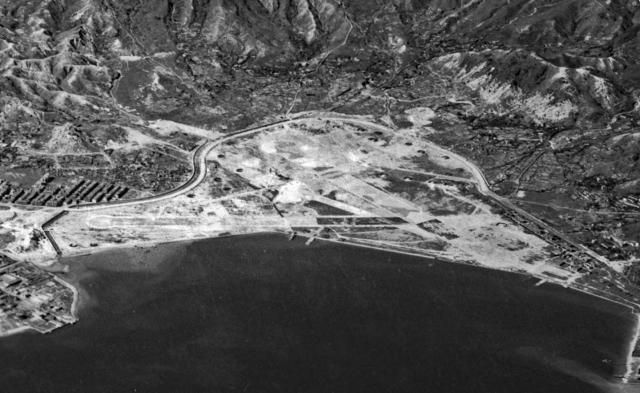
While there are aerial images of Kai Tak Airport just before WW11 and just after, few aerial images with discernible detail of Kai Tak airfield during the Japanese occupation have surfaced so far. This one has been extracted from a well-known hi-resolution image taken during an air raid by the American 14th Air Force on 16 October 1944.
The runways appear to be far from complete and useable unless they have been well disguised and camouflaged. These runways were used after liberation in 1945, and later had to be strengthened due to POW’s sabotage. They remained in use until 1958 when superseded by the new long runway heading out towards the Lyemun Gap.
There appears to be little sign in this image of the Diamond Hill hangar erected off-site across the Sai Kung main road by the Japanese, although there may be a base slab but no structure. More recently it has been referred to as the “RAF hangar” since its rediscovery about 20 years ago in squatter factory areas about to be cleared near Diamond Hill MTR station. See related postings on Gwulo.
The numerous black ‘u’ shapes are aircraft protection bunkers or revetments scattered around the site and appear to be empty of aircraft. Presumably, the resident fighters are in the air protecting the airfield during the air raid.
The pre-war Civil hangar and its control tower have completely disappeared, although the nearby civil seaplane ramp remains.
The original nullah discharging near the sea-plane ramp where the Pan American Sikorsky Clipper met its demise during a Japanese attack can just be discerned
The new larger nullah extension bordering the site next to the redefined Kowloon City boundary must have been a major piece of civil engineering to dig out and place granite block lining walls into it.
The pre-war RAF hangar that was on the right-hand end of the seawall was dismantled in December 1941 pending airport development by the HK government. It is believed that this was partially re-erected by the Japanese on the Diamond Hill site. The pre-war RAF seaplane ramp is present in this image.
Comments
IDJ's Nov 1944 photo
I wonder whether there is an exact provenance for this image so that a copy with the highest possible resolution could be sought. The research group at HKU I work with is trying to establish exactly what was left of the old Kowloon Walled City walls - if anything was - at the time of the reoccupation at the end of August 1945. As far as we know Japanese work on extending Kai Tak ended in October 1944, around the time of this image. A hi-res copy would therefore help is identify what the state of the walls was at that time.
Any help much appreciated.
StephenD
KLN City walls
It might to be more fruitful to look thro the images here for close views of the area.
https://www.royalnavyresearcharchive.org.uk/MONABS/M8_Gallery.html
The navy airmen were on site immediately after the surrender, and when their earlier photo galleries were posted on-line I recall they had pictures taken in the area by those just "wandering about" in free time, taking pics of local sites of interest.
These images seemed to have be "culled" from the present site galleries, No doubt the sites owners will still have access to them.
Walled City
Thanks Ian. The Nabcatcher images I knew of though, sadly, none seem ever to be pointing in the right direction. I'll follow up with the site managers to see what may be in the collection but not online.
I'm assuming that the image you posted is an enlargement from one of the images in the FD Roosevelt Presidential Library? I think I have identified which one, so we can ask the library whether they have a hi-res image (the highest res online is pretty lo-res).
Have you (or has anyone) any idea where all the other images from that particular raid may be found, if they still exist ? The B-24s (28) and B-25s (8) that took part in the raid could be equipped with cameras that began taking timed shots (can't find out the exact interval, but it was c.10-15 seconds) as soon as the bomb bay doors opened, though I don't know how many of the aircraft were so fitted. So, any one aircraft's bomb run would have been likely to realize >12 images, which means that somewhere, from the 16-10-44 raid, there could be up to four hundred or so images!
StephenD
This author should know
This author should know, he was posting messages on Gwulo prior to this book being published.
Bold Venture-The American Bombing of Japanese Occupied Hong Kong, 1942-45 by Steven K. Bailey gives a detailed account of the bombing raids on the Colony.
I have seen photo paper reels of sequential bombing contact print shots of raids over HK, but that was in the late 1990s.
I've no idea who might have them now.
I seem to recall a US Air Force facility (museum?) at an Alabama air base has been a source of bombing raid images
Walled City
Thanks Ian. I know Steven Bailey so, good idea, I'll see what he can offer.
Best, StephenD
Walled City / Nullah
These two are near to where I live, and I've often wondered if there is any connection between the two. As IDJ notes, the new nullah that the Japanese built would need lots of granite blocks, so is there any chance the blocks from the old Kowloon City Walls were recycled to line the nullah?
Below is the original photo…
Below is the original photo that the above picture has been cropped from. Source is the US National Archives. It includes the original source where the negative possibly might be found for a higher resolution view of the Kowloon Walled City.
The below pic from the same series may be a better source as it have a more detailed view of the Kowloon Walled City site.
The US National Archives also contains a couple of dozen other high resolution shot of the 16 October 1944 bombing mission over Hong Kong including pre mission reconnaissance photos, however none of the other pictures include a better view of the Walled City.
I also have these two photos…
I also have these two photos from the HKPL which show there area - they are part of a series and the library may hold more photographs that include the Walled City:
KWC walls
Thanks Herostratus. Steven Bailey has sent me some images from 1943 and 1944 he acquired from the US Air Force Museum. Sadly they're fairly ambiguous, though seem to confirm that the destruction of the KWC walls was ongoing in 1943 and pretty much complete by October 1944.
What's at issue for the research we're doing is quite how complete the destruction was and, so far, it doesn't look as though any aerial photography provides knock-down certainty by way of an answer. All we can say is that it looks as though the destruction was at least 90% of the walls, with maybe something left around the NE corner.
The problem is being able to distinguish clearly between the dusty white bare ground remaining where the walls were removed, and the dusty white of what may be rubble or remaining wall courses. The shadows that appear in some images are very hard to interpret - the tendency to see what one wants to see being the problem!
There don't appear, so far, to be any ground level images of the KWC and Pak Hok Shan from late 1945 or very early 1946 that might help resolve exactly what the state of things was at the time of the reoccupation. The Nabcatcher images always seem to leave KWC and Pak Hok Shan out of shot.
StephenD
I had a look to see if I…
I had a look to see if I could find any photos of the area immediately post war and this was the best I could find:
If one squints the right way there looks to be part of the southern wall still there (mid-left of the photo) but it could just as easily be white patches of ground.
It may be worth reaching out ho the Royal Naval Research Archive as they say they have higher resolution photos available upon request which may help work out if anything of the wall is actually left.