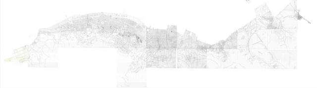
Thanks so much for doing this. I noticed that the top right map had a little extra detail outside the map, to wit, tbe Bay View Hotel. Could you add that extra little bit?
...
So David, what do we do next to get this as a map?
The next step is to make a Geotiff copy of the image, aligning it to the map, and warping it so that the streets and buildings on the paper map match up with a modern map. You can use the open-source QGIS software to do this.
As it is the most time-consuming of the steps, and something you don't want to do twice if possible, it would be even better if it could be done with a more detailed set of images so that we can read the names and numbers. Could you try to see if the PRO will provide higher-resolution copies?
One big map is better, otherwise each quadrant would end up being a different layer on the overlay map, where we want one layer for the whole thing. Plus, if you're lucky and the paper map fits the modern map well, you can get a rough match for the whole map and then just concentrate on matching up the areas that don't fit.
I aim to have less than half a block error between the old and new maps, so that the markers we add using the modern maps have a good chance of showing up over the right building on the old map.
Is there a tutorial you would recommend for the QGIS software as I am having trouble picking the correct coordinate reference system selector to align the maps properly. Thanks.
Comments
So David, what do we do next
Thanks so much for doing this. I noticed that the top right map had a little extra detail outside the map, to wit, tbe Bay View Hotel. Could you add that extra little bit?
...
So David, what do we do next to get this as a map?
The next step is to make a
The next step is to make a Geotiff copy of the image, aligning it to the map, and warping it so that the streets and buildings on the paper map match up with a modern map. You can use the open-source QGIS software to do this.
As it is the most time-consuming of the steps, and something you don't want to do twice if possible, it would be even better if it could be done with a more detailed set of images so that we can read the names and numbers. Could you try to see if the PRO will provide higher-resolution copies?
Regards, David
Is it better to do a quadrant
Is it better to do it quadrant by quadrant or to put all the maps on to one great big map and then fit it on?
One big map is better,
One big map is better, otherwise each quadrant would end up being a different layer on the overlay map, where we want one layer for the whole thing. Plus, if you're lucky and the paper map fits the modern map well, you can get a rough match for the whole map and then just concentrate on matching up the areas that don't fit.
I aim to have less than half a block error between the old and new maps, so that the markers we add using the modern maps have a good chance of showing up over the right building on the old map.
Hi David
Hi David
Is there a tutorial you would recommend for the QGIS software as I am having trouble picking the correct coordinate reference system selector to align the maps properly. Thanks.