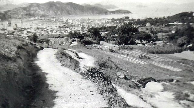
The local geography in brief revealed by this picture is as the following:
Here the Chuen Li Choi Yuen or the CLCY village and its surrounding forest were amid the forested area beyond the farmer's field of the foreground. This rocky headland was the hallmark of the region being known as the Tai Shek Hou or the Huge Rock Pass. It was only few meters by the water of the bay as villagers walked by on the narrow pass at the sea level. The CLCY village was at about 30 to 50 feet level.
This part of the Fairy Well region is at a higher ground than the CLCY village, was at about the 100 to 120 feet level. Therefore a good portion of the nearby roll-off landscape, between the 50 to 100 feet level, was totally hidden in this photo. That included the field of Guava Plantation and the Dong Goong Charity Cementry. The pathway on the very foregorund was on a downhill slope, it was a side track off the famous Peak Road West and the junction was also completely hidden from the view here.
The further roll-off at the very left of the picture, that is just on the west side of the CLCY village was the area I called The Black Forest, a place so special to us as we kids had encounted the long-eared wild man with heart-pounding experience for some times.
One of the few families here on the Fairy Well farming village was the Changs. They spoke the Hakka dialect. My dad knew of them as friends and neighbours. When they talked, it sounded like very choppy. Yet the Hakka's folk song or the Mountain Melody was a very popular style of folk songs over the southern China.
can you hear........ the Hakka's Mountain Melodies.... and the echos :
' the hills so alive.....the air so fresh.... free is everywhere for me to go
I remember you`re account of the Wild Man here about 1-2 years ago.Am I right in saying you also saw him on a Cheung Chau beach? Do you think he was a human who had "turned wild" through homelessness or was he a genuine ape of some sort?
Also you mentioned about 2 weeks ago the possibility of giant salamanders in Hong Kong? Any more news on that?
With the help of the Zeiglers photos, I can pin-point the exact location of my childhood encounters with the long-eared wild man near the the CLCY forest which separates the bay water and a tiny enclave off the slope all the way down from the Fairy Well's farmer's field as you can see in the far left. Due to the line of sight, only the taller trees are visible here.
I really don't think he was a homeless. He kept his territory. His furs dress was unique but very funny looking. Nothing he wore was from any store. Seashells for buttons and ornaments. Sometimes we wondered if he spoke the same speech like Taizan, the jungle hero.
That was in the early 1950s.
I went back the same location in the 1960s, there stands a new village of several family. My friend Wing was one of them. There was no trace of any wild man.
As previously mentioned, the CLCY village by the bay is on the same direction right beyond the pathway.
Then moving the view to the right, just around the Police Station, which stands tall on a little hill is the Nam Zer Tong area. You can see part of the upper portion of the St. John Hospita too.
Moving a bit closer is the ridge and flat field that is the site of the CC Government School. Looks like still under construction and appears to be a patch of white reflection in the picture. The ground seems to be very raw, and that still not yet being residential along the School Road route. Maybe due to the European Zone Bylaw, no houses are standing there as seen in the picture.
Pulling the view slightly closer, another small hill with couple of boulders among its top is the headland behind the Hung Shing Temple and the Fong Pin Hospital. There are many many old grown trees forming one of the several forests on the urban area. This is the same area of today's Kam Kwong Kindergarten and the Christ Church of China. In this picture the features are being overshadowed by the CLCY and Fairy Well forests. However Part of the Tai Choi Chuen remains visible as a brighter farmers land. The famous twin Erythrinas trees should be around there too. But it's hard to see them just now. More research is necessary. Other huge trees are Chinese Huckleberry, Bayan, Flaming Flowers. Wild Walnut or Chestnut, Cotton Ball, some Royal Palms .......etc. My best guess is that this group of trees appears as a belt of dark patch of the Tai Choi Chuen as seen here.
Since the route of the air traffic beacon had been leading all the airplanes flying over the Twin Erythrina trees, it makes sense to seek out the airway of this beacon in the picture.
The starting point is where the photo-taker stood from this Fairy Well area. The target point is roughly the mid-point between the Police Station and either the St. John Hospital or the CC Government School. The air traffic would follow such wireless directional beacon, the CC NDB. heading north-east towards the Victoria Harbour.
With such a clue, I can be sure to locate the Twin Erythrina Trees.
The single huge tree below the School image, mentioned earlier, is the huge Lychee tree on the school field near School Road, and further below the belt of tree group is on a small hill separating School Road from Tai Choi Chuen.
The Twin Erythrina should be within this mix of tree group. Precisely they are just to the left below the Lychee tree image, almost overshadowed by the tree images on the foreground as seen here.
Recently, there I check upon an aerial photo of CC taken on Nov 25 1924 provided on gwulo, it clearly depicts more details and light on the CTK site. So therefore I have to correct myself for things I wrongly suggested before.
Firstly, the entire Cheung Chau Government School site was still a local village with much forested landscape,the land was not flat at all. The site was at the low end of two or three ridges. This village had to be relocated elsewhere and the land to be bull-dosed for creating a several hectages of level land. But all these was not in this photo. So can tell it really was about 1930s or earlier.( However, higher above here is a long strip of bright line. That should be the new terrance for houses to be built over the west side of the Peak Road.)
Secondly, the hillet with a very bright object ( it looks like a gigantic UFO safely landed upright ) should be the site between School Road and the Tai Choi Yuen's farmland. It must be the same hillet where the Erythrina trees located. The reason I think the very bright object was being a huge rock or a muddy rocky monster by reason of the shape and sun-lit intensity. During my entire residency on Cheung Chau, I went to the Kindergarten ( Sum Sum Kindergarten) over there and later it became my home address till my departure from the colony. Since 1950s, I think the huge rocky topology had been broken down for stone products. What remained were still quite massive. There were two ( could be just one below ground ) still standing up like small houses and we climbed on them sometimes.
Nearby off to the road of Tai Choi Yuen Road, there was a construction company named Deng Mei Kee. They were most likely having involved to break up the huge rock for their construction activities. My guess without proof.Yet right beside the rock site, there lived the families of stonecutters.They were Hakka people.
I can identify there was already the CTK building on the site ( partially blocked by the trees and house on the foreground). I can see the Crowns of the Twin Erythrina Trees. Historical accounts about the 1800s Portuguese activities around South China area leads me to speculate there was a connection about how the Indian or African Coral trees ended up here. The site could once be a soldier or sailors camp ground when they were in the joint effect with the Qing Dynasty Regime to seek out the pirates headed by Cheung Po Tsai. And before the Christ Church, there could be several more Erythrina Trees. We never know unless we could check on the Portuguese Naval Achives around 1800s in Macao and Cheung Chau area
Comments
View to the north from the Fairly Well region
Hello everyone,
The local geography in brief revealed by this picture is as the following:
Here the Chuen Li Choi Yuen or the CLCY village and its surrounding forest were amid the forested area beyond the farmer's field of the foreground. This rocky headland was the hallmark of the region being known as the Tai Shek Hou or the Huge Rock Pass. It was only few meters by the water of the bay as villagers walked by on the narrow pass at the sea level. The CLCY village was at about 30 to 50 feet level.
This part of the Fairy Well region is at a higher ground than the CLCY village, was at about the 100 to 120 feet level. Therefore a good portion of the nearby roll-off landscape, between the 50 to 100 feet level, was totally hidden in this photo. That included the field of Guava Plantation and the Dong Goong Charity Cementry. The pathway on the very foregorund was on a downhill slope, it was a side track off the famous Peak Road West and the junction was also completely hidden from the view here.
The further roll-off at the very left of the picture, that is just on the west side of the CLCY village was the area I called The Black Forest, a place so special to us as we kids had encounted the long-eared wild man with heart-pounding experience for some times.
One of the few families here on the Fairy Well farming village was the Changs. They spoke the Hakka dialect. My dad knew of them as friends and neighbours. When they talked, it sounded like very choppy. Yet the Hakka's folk song or the Mountain Melody was a very popular style of folk songs over the southern China.
can you hear........ the Hakka's Mountain Melodies.... and the echos :
' the hills so alive.....the air so fresh.... free is everywhere for me to go
..........'
from this picture.?
Tung
Hi again Tung
Hi again Tung
I remember you`re account of the Wild Man here about 1-2 years ago.Am I right in saying you also saw him on a Cheung Chau beach? Do you think he was a human who had "turned wild" through homelessness or was he a genuine ape of some sort?
Also you mentioned about 2 weeks ago the possibility of giant salamanders in Hong Kong? Any more news on that?
Richard
The long-eared wild man
Hello Rich,
With the help of the Zeiglers photos, I can pin-point the exact location of my childhood encounters with the long-eared wild man near the the CLCY forest which separates the bay water and a tiny enclave off the slope all the way down from the Fairy Well's farmer's field as you can see in the far left. Due to the line of sight, only the taller trees are visible here.
I really don't think he was a homeless. He kept his territory. His furs dress was unique but very funny looking. Nothing he wore was from any store. Seashells for buttons and ornaments. Sometimes we wondered if he spoke the same speech like Taizan, the jungle hero.
That was in the early 1950s.
I went back the same location in the 1960s, there stands a new village of several family. My friend Wing was one of them. There was no trace of any wild man.
That is really a mystery.
Tung
WILD MAN
Thanks very much.
A slit view of the Tai Choi Chuen from this picture
As previously mentioned, the CLCY village by the bay is on the same direction right beyond the pathway.
Then moving the view to the right, just around the Police Station, which stands tall on a little hill is the Nam Zer Tong area. You can see part of the upper portion of the St. John Hospita too.
Moving a bit closer is the ridge and flat field that is the site of the CC Government School. Looks like still under construction and appears to be a patch of white reflection in the picture. The ground seems to be very raw, and that still not yet being residential along the School Road route. Maybe due to the European Zone Bylaw, no houses are standing there as seen in the picture.
Pulling the view slightly closer, another small hill with couple of boulders among its top is the headland behind the Hung Shing Temple and the Fong Pin Hospital. There are many many old grown trees forming one of the several forests on the urban area. This is the same area of today's Kam Kwong Kindergarten and the Christ Church of China. In this picture the features are being overshadowed by the CLCY and Fairy Well forests. However Part of the Tai Choi Chuen remains visible as a brighter farmers land. The famous twin Erythrinas trees should be around there too. But it's hard to see them just now. More research is necessary. Other huge trees are Chinese Huckleberry, Bayan, Flaming Flowers. Wild Walnut or Chestnut, Cotton Ball, some Royal Palms .......etc. My best guess is that this group of trees appears as a belt of dark patch of the Tai Choi Chuen as seen here.
Now moving closer is back on the Fairy Well area.
Tung
The Huge Twin Erythrina Trees on old Cheung Chau
Since the route of the air traffic beacon had been leading all the airplanes flying over the Twin Erythrina trees, it makes sense to seek out the airway of this beacon in the picture.
The starting point is where the photo-taker stood from this Fairy Well area. The target point is roughly the mid-point between the Police Station and either the St. John Hospital or the CC Government School. The air traffic would follow such wireless directional beacon, the CC NDB. heading north-east towards the Victoria Harbour.
With such a clue, I can be sure to locate the Twin Erythrina Trees.
The single huge tree below the School image, mentioned earlier, is the huge Lychee tree on the school field near School Road, and further below the belt of tree group is on a small hill separating School Road from Tai Choi Chuen.
The Twin Erythrina should be within this mix of tree group. Precisely they are just to the left below the Lychee tree image, almost overshadowed by the tree images on the foreground as seen here.
Tung.
Update....
Recently, there I check upon an aerial photo of CC taken on Nov 25 1924 provided on gwulo, it clearly depicts more details and light on the CTK site. So therefore I have to correct myself for things I wrongly suggested before.
Firstly, the entire Cheung Chau Government School site was still a local village with much forested landscape,the land was not flat at all. The site was at the low end of two or three ridges. This village had to be relocated elsewhere and the land to be bull-dosed for creating a several hectages of level land. But all these was not in this photo. So can tell it really was about 1930s or earlier.( However, higher above here is a long strip of bright line. That should be the new terrance for houses to be built over the west side of the Peak Road.)
Secondly, the hillet with a very bright object ( it looks like a gigantic UFO safely landed upright ) should be the site between School Road and the Tai Choi Yuen's farmland. It must be the same hillet where the Erythrina trees located. The reason I think the very bright object was being a huge rock or a muddy rocky monster by reason of the shape and sun-lit intensity. During my entire residency on Cheung Chau, I went to the Kindergarten ( Sum Sum Kindergarten) over there and later it became my home address till my departure from the colony. Since 1950s, I think the huge rocky topology had been broken down for stone products. What remained were still quite massive. There were two ( could be just one below ground ) still standing up like small houses and we climbed on them sometimes.
Nearby off to the road of Tai Choi Yuen Road, there was a construction company named Deng Mei Kee. They were most likely having involved to break up the huge rock for their construction activities. My guess without proof.Yet right beside the rock site, there lived the families of stonecutters.They were Hakka people.
I can identify there was already the CTK building on the site ( partially blocked by the trees and house on the foreground). I can see the Crowns of the Twin Erythrina Trees. Historical accounts about the 1800s Portuguese activities around South China area leads me to speculate there was a connection about how the Indian or African Coral trees ended up here. The site could once be a soldier or sailors camp ground when they were in the joint effect with the Qing Dynasty Regime to seek out the pirates headed by Cheung Po Tsai. And before the Christ Church, there could be several more Erythrina Trees. We never know unless we could check on the Portuguese Naval Achives around 1800s in Macao and Cheung Chau area
Logical?
Thanks for the aerial photo of 1924 Cheung Chau
Tung