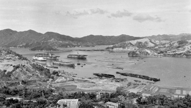
The image titled "Castle Peak Way" posted earlier with the mysterious island appears to actually be Gin Drinkers Bay as this picture shows the island in the middle background. I believe it is still there supporting the end of the original Tsing Yi road bridge where it lifts off over the Ramble Channel.
Date picture taken
15 Jun 1960
Gallery
Shows place(s)

Comments
Gin Drinkers Bay- ship breaking
There is an aerial photo on page 226 of Mapping Hong Kong which shows the causeway with a break in it. On page 225 it does not show any causeway.
I assume the aerial photo [1964] was taken after the one above when the area behind the causeway was being reclaimed.
Interesting to note the three converted aircraft carriers there. Two could be possibly Rapana and Miralda, both broken up in Hong Kong between 1958 to 1960.
Re: Page 170 of the Aerial Photo book...
Hi there,
Page 170 of the book shown the Gin Drinker's Bay. On the page there didn't seem to be any islands there. The causeway/breakwater would seem to be the reclaimation area which also acted as the city dump of the time. I remember the bay was nicknamed Lap Sap Wan (垃圾灣) back then. If you have Denis Bray's book it's mentioned on page 80 onwards.
Best Regards,
T
Gin Drinkers Bay- ship breaking
Appologies, Rapana and Miralda were converted back to Merchant ships immediately post war.
Bairoko, Sava Island and Shramrock Bay ex USN, were broken up in Hong Kong in late 1959 to mid 1961.
青洲?
青洲?
aircraft carriers
On the left of the photo, there are three WWII aircraft carriers berthing among some cargo ships..
The China Mail reported in 13 September 1960 that three Hong Kong companies, Hong Kong Rolling Mills Ltd., Dah Cheong Hong and Sun Fung Iron Works Ltd., bought seven aircraft carriers from US authorities for scrapping. Six were scrapped in Hong Kong, and the seventh in Japan.
The report mentioned Dah Cheong Hong had three of the carriers scrapped in Gin Drinkers Bay. This photo shows, very likely, those carriers mentioned.
Breakwater
On the 1952 map http://www.hkmaps.hk/map_1952.1.html there is no break. But on the 1957 map http://www.hkmaps.hk/map_1957.html shows a north-south breakwater connecting with Pillar Island.
The stages of reclamation round the Kwai Chung areaand Pillar Island supporting the Tsing Yi Bridge is shown clearly in the 1995 map http://www.hkmaps.hk/map_1995.html.
breskvar
Re: Gin Drinkers Bay
Another photo of the same vessels appears here on Flickr.
China Mail dated 15 July 1959 reported that Hong Kong had become the world's busiest ship-breaking port. At the end of June, 47 vessels totalling 275.000 tons were being broken up whilst another 5 vessels totalling 29,000 tons were awaiting break-up berths.
The work is mainly carried out in Cheung Sha Wan and Ngau Tau Kok but reclamation works may displace the breakers' yards. The industry believed that Gin Drinkers Bay was the ideal place for their need as it offered a natural shelter and was close to the harbour and deep enough for large vessels.