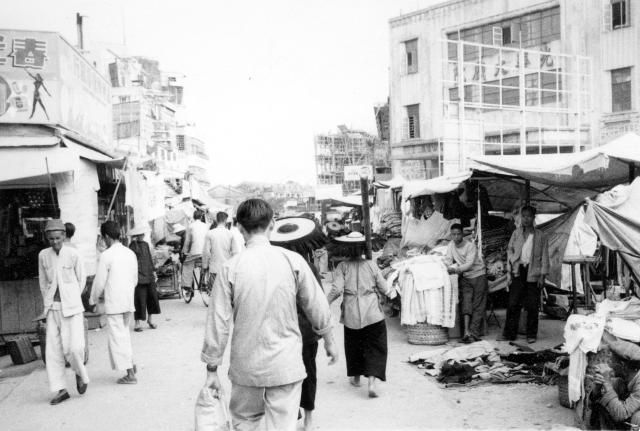
Yuen Long centre. Kuk Ting street from the main Castle peak road. Following the correspondence, I am very happy to change the location to " Yuen Long centre. On the Tai Tong Road (formerly Tai San Street) looking northwards to the main Castle Peak Road.
Thanks to you all for helping with this location. Andrew
Date picture taken
1958
Gallery
Comments
Tai Sun Street
This street has been named as Tai Sun Street at the beginning and later it has been consolidated into Tai Tong Road.
Hi Terewong
Hi Terewong
Thanks for the comment. I have always thought that, when I took this photograph, I was looking from the Castle Peak Road oblique crossroads in a Northerly direction as was the photograph taken at the same time - but it was a long time ago! If you are sure that this one was taken looking to the south I'll happily change the title to Tai Sun Street or Tai Tong Road, whichever you think best.
Best wishes Andrew
I share the recent street
I share the recent street view from Google Maps, all the world has changed except the building at the left in the photo, still exist there and going to be a jewelry's flagship store
Tai Tong Rd
http://maps.google.com/maps?layer=c&panoid=570HSdgeVk0S2pzUaygQ-w&cbp=1…
You took this picture at 1958, almost 60 years ago?
Andrew if you look at the
Andrew if you look at the street view provided by Terewong, the little man is looking northeastish from Castle Peak Road. So you are right you did take this photo looking north way back.
Happy New Year.
breskvar
Kuk Ting street
Kuk Ting street ( the market of trading rice in the past ) is located at the far end in the center of the picture.
I like this photo and also the next one very much, these two pictures showing the Tai Tong Road from two different angles.
Hi Breskvar and Terewong
Hi Breskvar and Terewong
I'm a bit confused now! Are you saying, Breskvar, that Terewong's Google Street view and my photograph were both taken from the Castle Peak road as I first thought. I'm afraid that I cannot positively match the buildings to which Terewong refers - maybe my eyesight is not as good as it used to be!
Please let me know what the description / title of my 1958 photograph should be. Yes, terewong all the images in that 1957/8 folder would have been taken between November 1957 and August 1958, with the majority, including all the colour ones, in 1958.
Best wishes to all of you who keenly follow David's Gwulo project for a good year in 2016
Andrew
comment changed?
I think Terewong has changed his/her comment because I am sure they had said earlier one of the buildings in your photo was still around?
The modern streetview (provided by Terewong) shows the area just south of Castle Peak Road looking north. Andrew says his photo was taken at Castle Peak Rd looking north i.e, slightly further north than the streetview. So who is correct?
It seems to me that both locations are possible given the aspect of the buildings (buildings change over time but many new replacements still retains the aspect/orientation of the old ones due to the plot shape).
So either Andrews picture shows the junction where Kuk Ting St meets Castle Peak Road or Castle Peak Road is further north - probably where the building under construction is. Either way it appears Andrew's recollection of looking north is correct.
EDIT: looking at Centamap, it appears that the building on the ne corner of Castle Peak/ Kuk Ting junction was built in 1958, so perhaps the scaffolding in the distance is indeed that building being constructed? The address is 69 - 75 Castle Peak Rd.
description
I mean the description is better to be: { Yuen Long centre. Tai Tong Road (former "Tai San Street") to the main Castle peak road. } Thanks Andrew to share this photo, may I ask if you have any more photos about the Yuen Long center in 1957/1958 ? any why you come to Yuen Long town, I am just curious.
In this photo, the building at the right is Kong Wah Theatre (光華戲院, I think it was the second cinema/theatre in the town), the shop at the left is an electrical appliance shop (春光無線電器行), this shop has been moved to the Castle Peak road (大馬路) afterwards and located at the ground floor of the Nixon Library (a library built after Richard Nixon visited Yuen Long in 1953). Those people on the road were walking towards Kuk Ting Street, close to Yuen Long new market (established in 1915) .
Hi Everyone
Hi Everyone
Sorry for the delay in replying. This month we are experiencing monsoon like rain in the North of England where we live and I took advantage of a fine spell this morning to fell a tree in our small wood - some of next year's firewood.
I think that Terewong is almost certainly correct about where I stood to take this photograph (looking north towards Castle Peak road). I'm almost certain that the other one was taken looking north from the oblique crossroads on the Castle Peak road. What puzzles me a bit is that I have no memory at all of exploring anywhere in Yuen Long away from the main Castle Peak Road - but it was only a very short visit and 58'years is a long time ago! I'll not change the title, etc. to Terewong's suggestion for a day or two in case anyone strongly disagrees with him/her.
Please excuse my uncertainty about the exact locations of some of my old photographs. In 1958, I only visited Yuen Long very briefly on one or possibly two days and didn't possess a map of there or of the New Territories in general so I was only vaguely aware of where I was, but I hoped that if I kept changing buses and heading in a clockwork direction I'd eventually get back to Kowloon. I travelled by local buses and on that day in Yuen Long I vaguely recall changing buses in an open air bus 'terminus' on some waste ground at the extreme Eastern end of the town a short distance to the East of the crossroads and on the southern side of the Castle Peak road. It cannot have been far as Yuen Long was still a small market town. I believe that from there onwards it was paddy fields until one got to Kam Tin. I remember buying a good meal of curried eggs in a small restaurant on the north side of the Castle Peak road just to the west of the crossroads. I'll bet nobody remembers that one. Prove me wrong!
Sorry, Terewong, those are the only photographs that I have of Yuen Long in 1958.
Best wishes Andrew
Thanks Andrew ~
Thanks Andrew, I love your photos and your sharing. Happy 2016. tere