Our latest hike had us scrambling, climbing, and at times crawling around the Shing Mun Redoubt above Tsuen Wan. This piece of Hong Kong's wartime history is well described at hksw.org/Shing%20Mun.htm. That web-page also shows a copy of the map by Mike Nolan that we used. We started off from the Shing Mun reservoir and walked up the Maclehose Trail to the most obvious landmark, an electricity pylon built at the top of a low ridge. If you go under the pylon to the edge of the ridge, you can see the ruins of pillbox 402.

Head back under the pylon, and you'll see the roof of one of the tunnels stretching out like a path in front of you. Originally they were covered with earth, but in many places that has washed away.

The square blocks you see are ventilation shafts. These were poorly designed -- as you can see they are wide enough for a soldier to climb down and into the tunnels.

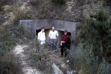
A short way along the tunnel you'll find a hole in the roof, where you can climb down inside. Much of the damage to the tunnels was done by British guns firing on the invaders from Mount Davis on Hongkong island.

Be careful of the mud, but the tunnels are high enough to move through easily.

Someone with a sense of humour originally named the tunnels after famous streets in London. Here you are walking through Picadilly, moving away from pillbox 402.

Take the first right turn into Haymarket, which will take you out to pillbox 403.
 Whoa, something just ran across the torch beam -- a rat? a snake? Fortunately just a small frog enjoying the damp, muddy conditions.

It looks as though cracks in the walls have been a problem for local residents since long before there were high-rise apartment blocks. These glass plates can be found at many locations in the tunnels, dated 20 Jan 1940, and apparently put in place to check for further subsidence.

From pillbox 403 you'll be overlooking the back of Tsuen Wan. It's overgrown now, but when the hillsides were bare (as is shown in old photos of the redoubt) you'd have had a clear view of the surrounding area.

From here we retrace our steps to Picadilly, and turn right up the steps. At the top you'll come to an opening, with a choice of Regent Street or Shaftesbury Avenue.

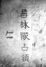
Enter Shaftesbury avenue, and follow this path until you reach an open section where it crosses the Maclehose trail. In this passage you'll find some graffiti that is much older than the recent spray-paint variety. This is said to be the name of the group of Japanese soldiers that captured the redoubt, that they chipped into the wall after their victory.

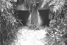
On the opposite side of the trail you'll see the entrance to Charing Cross,

but unfortunately a peek into the tunnel shows it is flooded.

Instead we followed the Maclehose Trail up the steps to the Observation Point that is the highest point of the redoubt. You can see why it was chosen, as it has a view from Tsuen Wan round past the upper and on to the lower Shing Mun reservoirs.
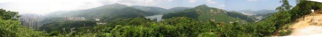
Far left is Tsuen Wan, then Tai Mo. Next you see the upper Shing Mun reservoir, and at the right is the lower reservoir. This panorama was taken from the Shing Mun Redoubt, part pf HK's wartime defenses described in more detail here.
Inside the observation point you'll see a tunnel heading down to the "Strand Palace Hotel", which was the name of the headquarters. Unfortunately that tunnel is blocked, so we walked down the hill to the HQ instead. That is also full of silt, and we already knew the Charing Cross was filled with mud and water, so after a quick look inside we headed back into Shaftesbury Avenue. From there we take a right turn into Oxford Street, and head along to pillbox 400.

Once again, there is not much of the pillbox left to see. My fellow hiker tells me that the pillboxes in the New Territories were blown up after the war, when there was concern they would be used by communist insurgents.

Squeezing back into the tunnel from Pillbox 400 is a tight fit -- don't have a big lunch before starting this trip!

Oxford Street is in the best condition of all the passages, and still has its drainage pits working well, so the passage is dry and free of mud.

At pillbox 401 you are at the northern tip of the redoubt, with a clear view along the lower reservoir.

We thought we would soon be finished. We cut from Oxford Street into Regent Street.

From there we walked back to Picadilly, planning to see the Regent Palace Hotel, which was originally the main entrance to the redoubt. We could see some light in the passage to that entrance, but the gap was too small to squeeze through.

Heading back outside, we see a "Danger, keep out" sign. These are usually a good indication of something interesting, so surely the entrance must be close by?

In fact we spent another hour crashing through undergrowth until we finally found signs of an entrance.

There it is, all points covered! 
It took us most of an afternoon to work our way around, but it was well worth it. From that main entrance we followed the path down through the BBQ pits, finishing off with a short walk along the reservoir, and back to the minibus.

Photos that show this Place
Comments
You can take MTR to Tsuen Wan, then try taxi to get up to Shing Mun Reservior. Walk along the road (not the staired path) to the reservior. You may find a barbeque site with a big sign showing the starting point of the 6the sector of MacLehose Trail. Walk up hill and you will reach the Observation Post about half an hour. If you go from Central...about one and half hour can reach there...
There should be a minibus to get to the reservior from Tsuen Wan, but I dont know if you are familiarize with Tsuen Wan, because it is a little bit to find......
The relevant hiking map for the area is the 'North-East & Central New Territories' map of the Countryside Series.
The first landmark to watch for as you walk the maclehose trail is the electricity pylon near pillbox 402, as mentioned above. You can also see a satellite view of PB402 - zoom out a couple of times to see where it is in respect to the reservoir (and ignore the 'Shing Mun Tunnel Rd" shown on that map, as it is out of sight in a tunnel far beneath you).
MrB
Print out copies of the Mike Nolan map and possibly the satellite view of PB402 mentioned above, then take along the usual things you need for a summertime hike in Hong Kong: water, mozzie repellant, mobile phone, hat, etc. Long trousers will be hot, but better than shorts for scrambling around and avoiding insect bites.
Go with a friend if at all possible - always safer than hiking alone.
MrB
I studied shingmen in 94, pre-internet, went there several times in the course of six months , each time for many hours took about two hours of videotapes. It is fascinating. The mystery for me is still what precisely happened to the men there, and how the majority escaped.
I have an account of some fighting that happened there from a regimental history but no follow-up what happened to the men in the account and if they survived the war.
I'll review my material and be back later with more precise information and see if anyone has answers to some precise questions.
back later
cheers good work on your site!
Interesting reading from the HK Institute of Surveyors: http://www.hkis.org.hk/hkis/general/journal/SBEvol21b.pdf.
The naming of the tunnels and other important features of the Shing Mun Redoubt is nothing whatsoever with "somebody having a sense of humour."
Under the original defence plan, the unit designated to hold the left or western part of the Gindrinkers Line was the 1st Bn. Middlesex Regiment. This Regiment recruited from the East End of London. The soldiers earmarked to hold that position therefore carved or chiselled London landmarks into the tunnels for 2 reasons : -
(a) the names would remind them of home. In addition, British soldiers have always loved to leave their mark in various theatres by means of graffiti, carvings etc.
(b) there was also a far more practical reason for the naming of tunnels. Remember many of the senior officers & NCOs of the Bn. had served on the Western Front during the Great War. One of the problems associated with the fighting in that theatre was the difficulty of finding one's way through the trench system; support trenches and even front-line trenches could all look the same. Naming them just like streets enabled men to find their way from A to B easier & cut down the chances of getting lost in the trench system.
Naming the tunnels in the Shing Mun Redoubt had the same effect.
Note that I used the term "original defence plan." This, of course, was the plan which called for reinforcements for the defence of the Gindrinkers Line to be brought up from Singapore. When that plan was scuttled in 1940, the plan then was NOT to hold the Line. Before Gen. Grassett left HK in 1941 he revised the plan yet again. This time the Line was to be held thanks to the addition of 2 Canadian battalions to the strength of the garrison, which enabled the Line to be held by a Brigade.
Under this, the final plan, the 1st Bn. 2 Royal Scots were earmarked to hold the position previously designated to the Middlesex, as the latter had been converted to a machine gun battalion and were required to man pill boxes on the perimeter of HK island.
And in answer to the question why did the Royal Scots not change the names of London landmarks to those of Edinburgh or other Scottish cities; I think they had more important things to worry about so late in the day.
An account of the action at the redoubt written by Colonel Doi.
"The companies leading the attack assaulted the eastern position (shing mun redoubt). First a small number of troops threw hand grenades into the air ventilation chimneys of the connecting tunnels and engaged in fierce close-quarter fighting. In the meantime each tunnel exit was blocked by several men. Although the hand-tohand fighting was continued for more than an hour, a small number of enemy remnant continued to offer stubborn resistance."
- I suspect the 'stubborn resistance' were the last members of the defending force in the AOP
Interesting that he mentions men were placed outside the tunnel exits, I had not heard of that evidence before.
I staff officer quote from the Battle Box, regarding the loss of the redoubt.
"really caused chaos in Fortress HQ. I have never seen General Maltby more shocked or angry"
- Brg. Wallis tried unsuccessfully tried to persuade Lt. Col White (Commander of Royal scots) to attempt to retake the position.
-Apparently the failure of the Royal Scots diminished their reputation (up until their actions on the island that is), and rumours circulated that they shot their own second in command, Major Stanford Burn
The British Army is not, and was not, a democracy - certainly not in wartime. Brigade commanders did not "try to persuade" battalion commanders to attempt a counter-attack to recapture a position. An order is (and was) simply given and the commander gets on with it - or he is replaced and (hopefully) later court-martialled.
I believe what happened at Shing Mun was that Lt. Col. Simon White, C.O. 2 Royal Scots, was asked his opinion as to the likely success of a counter-attack. Nothing to say that a Brigadier cannot ask a Colonel for his opinion. White answered truthfully that he did not, in his view, feel a counter-attack would be successful.
Brigadier Wallis then discussed the situation with Major-Gen. Maltby, and they formed the view that a counter-attack would not work and they were left with no alternative but to withdraw from the Gin Drinkers Line and, by extension, the Mainland.
Thanks Tideswell27 for clarificaiton. You are very right about the military hierarchy and how it operates, I pulled that statement as an inference from the source I got those quotes (I actually cant remember what it was now) because the source used words that did not suggest any direct orders were given but that (as you mentioned) a discussion occured). I think that your account of the events is much more fitting.
However, the information was pulled from a military aide who was present and suggested that it was not as a 1-sided relationship as it would seem in the military. After all, The Royal Scots did have a very strained relationship with Maltby (who discusses the 'inability' of many of their leaders and the strained relationship in a 1947 War Office Report in the London Gazette). Because of evidence like this, I still feel some inkling that there might have been some unusual bit of give-and-take and that White did push against the idea (even if it was a request of his opinion as you said) to a point where Maltby did not want to upset the balance of the royal scots who seemed one of the less motivated troop contingents at the start of the conflict (many officers were replaced for ineffectiveness and drunkeness before the conflict, and some enlisted were found AWOL during the conflict itself).
Another point which requires correction in the original post is the suggestion that the pillboxes were blown up after the war, as concern had been expressed that they may have been used by Communist insurgents.
Your original poster could not be more wrong. The concern was that the pillboxes would be used - nay, occupied - by Nationalists (NOT Communists) who were fleeing the latter following the revolution in China.
The HK Government were not too happy at having all these Nationalists in the Colony, although many of them did not want to stay here. They wanted to get to Taiwan. In order to “discourage” them from staying in military installations like Mount Davis and Shing Mun, the Government tried to make such places “uninhabitable.” Opinions vary as to how successful the Government’s attempts were.
Many of the Nationalists settled in the area know as Rennie’s Mill, later Tseung Kwan O. They were quite high profile - up to 1997!
Just to add more uncertainty to the destruction story: amongst my sources of information when I was researching the PB's were two British Army Officers. They served in HK in an overlapping period between 1949 and 1954, and were stationed at times along the frontier. The earlier of the two commented that his unit was involved in the destruction of a PB that had been occupied by two "armed bandits". The method used was an army issue anti tank weapon - a PIAT. The second, as one of his duties, was involved in the destruction of Japanese PB's in the Frontier Area, at the request of the HK Police, who were having trouble with "insurgents" infiltrating the area. Two of the things he showed me were (1) a blank test paper given to Officers requiring them to calibrate - given the plan and details of a PB - how much explosive would be required, its type, and where it would be positioned and (2) photographs taken of his handiwork.
Whilst this deals primarily with the Japanese PB's, I think it indicates there were many reasons for the Government, Police and Army to consider the destruction of old Military structures a necessity.
Starts at 4:12: https://www.facebook.com/watch/?v=723024438243178
Link comes from the 5 Aug 2020 entry at http://www.hongkongwardiary.com/ - thanks to Rob for letting me know.
A video about the Shing Mun redoubt. Reviews the battle on Dec 9, 1941 with similation animation. Worth to watch.
Narration in Cantonese and only Chinese subtitles...