[2015-04-27 Update: GW notes this likely dates from mid-50s, not 1938 as noted on the map (see http://gwulo.com/comment/31453#comment-31453). I've changed the title and date accordingly.]
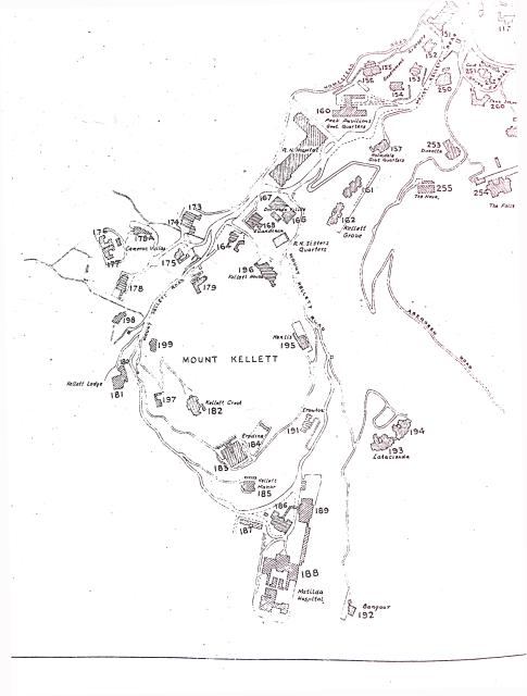
Portion of a map of the Peak District. Copy available from Survey & Mapping Office, their ref: HG36.
Date picture taken
1955
Gallery
Shows place(s)
Comments
Does the 1938 map show the
Does the 1938 map show the location of Strawberry Hill and Creggan ?
Creggan is #351, and
Creggan is #351, and Strawberry Hill is #354, matching the locations on the maps from 1912 and 1924.
1938 Map of Mount Kellett
Hi David,
Any chance you can post the other portions towards Wanchai Gap/Mount Cameron, now I have learnt these are considered part of The Peak.
Michael
Wanchai Gap / Mt Cameron map
Wanchai Gap / Mt Cameron map posted here: http://gwulo.com/node/13159
Regards, David
HK Government Officals' Residences
Thanks David,
Given that Kennedy-Skipton lived in 565 The Peak in the position Deputy Controller of Foods, where would the likes of the Colonial Secretary, Attorney General, Financial Secretary etc, have resided during this time frame ie:1938 to 1941?
rgds - Michael
Road Map of the Peak District
This map and the one at www.gwulo.com/atom/15669 are extracts from a larger map entitled "Road Map of The Peak District". I have a copy of the original. It doesn't have a date printed on it, but "1938" has been handwritten in the margin. Until today I'd assumed that 1938 was the year of its production or publication, but I've just realized it must have been significantly later.
Obvious discrepancies between the map and the year 1938 include;
1. Mount Austin Mansions is marked. It was built on the site of Mount Austin Barracks which stood until at least 1947, www.gwulo.com/node/3689.
2. No. 10 & 11 The Peak is not marked. The building was partly demolished in 1941 and probably fully cleared shortly after the war, www.gwulo.com/node/9536.
3. Peak Church is labeled "Peak Church Site", implying the building was no longer standing. It was badly damaged in 1941, never repaired and demolished in 1958, www.gwulo.com/peak-church-chapel.
4. Peak School is marked in two locations, one its present day site and the other in the building which is now Peak Fire Station. At www.gwulo.com/peak-school Davids post of 27-3-2012 informs us that Peak School operated at these two sites from 1954 for a few years.
5. Peak Road is labeled Stubbs Road, Mount Austin Road as Peak Road, Old Peak Road as Peak Road and Peel Rise as Aberdeen Road. Moddseys post of 23-4-2014 at www.gwulo.com/atom/13017 says the name changes took place on 1st September 1960.
The map probably contains many more clues from which it should be possible to date it accurately, but based on the above I'd say it dates from the mid 1950's.
Date of map
Thanks for spotting the mistake. I've updated the date.
Regards, David