Source: This image came from Flickr, see https://flickr.com/photo.gne?id=4644324097
Date picture taken
unknown
Shows place(s)
Source: This image came from Flickr, see https://flickr.com/photo.gne?id=4644324097
Comments
Re: Title
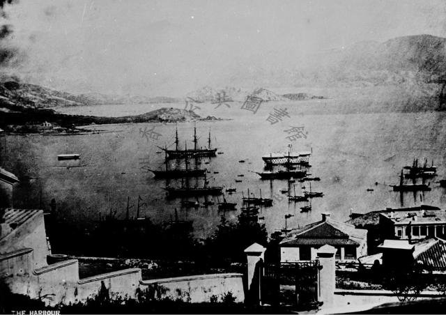
I think the Government caption is correct as the view is from the Albany above the Botanic Gardens.
Then where is the Mosque?
I've put a tentative tag on the Flickr site.
Not from the Albany?
Looking at maps or photos of the Albany, it had the botanical gardens between it and any buildings. But here the photographer looks to be a short distance away from the cluster of buildings on the right.
I can't recognise anything to give a better fix on the location though.
Re: Not from the Albany
Not exactly from the Albany Building as we know it but the area west of Government House near where the present day Albany Road meets up with Upper Albert Road. My guess is the stone pillars and gate is one of the entrances to the Botanic Gardens.
Not sure whether or not the building on the extreme right is Government House.
Re: Not from the Albany
Yes, maybe from round there, but I'm still struggling to match it up.
In front of the building that might be Government House is a flat area of land with a small pier. Maybe the cricket pitch? No trees around it yet though.
Re: Not from the Albany
I think the stepped wall on the left is the retaining wall that descends from the Albany (Building) and demarcates the western perimeter of the Botanic Gardens i.e. present day Albany Road.
Re; Harbour from the Albany
The building to the west of the Albany in the main photo I think appears in:
http://gwulo.com/the-albany?page=0#comment-13807
view of Kowloon Point
The transit joining the south tips of Kowloon and Blackhead Points and the transit across behind Blackhead Point to the low hills north of the Hung Hom peninsula's west shore plotted on the 1886 Hong Kong Harbour chart puts this certainly over to the west side of the Albany/Botanic Garden area.
Stephen D
Clearer copy
For a clearer copy of this pic, see https://gwulo.com/media/44543, where it has been dated c.1870 and from 1865 to 1879.
I think the building that is…
I think the building that is partly obscured by the right-side gate post is the one identified by Annelisec in her post of 1 April 2010 as "Gardiner House" ( "Gardener House" - Residence of the Lord Deputy of the Botanical Gardens - 1860s [????-????] .
As suggested above, the building on the right side of the pic further from the camera and with the almost flat roof is Government House.
Photo taken from Garden of "Devonia"?
This is an extract from the pic at https://gwulo.com/media/27938, dated 1870, postedby Klaus. Apologies for my amateurishly added markings. "X" marks the spot from where the photo at the head of this strong (the subject photo) was taken.
The photographer was in the garden at the side of a large residential bungalow (labelled No.5), in front of a small outhouse from where the garden drops steeply to a low, white, boundary wall. Two gate posts can be seen rising from the wall just below the "X". At the bottom-right corner of the garden as we look at it, the wall curves back up the hill. Another small, white building, with a pitched roof, (labelled No.4) sits just outside this corner of the garden.
The subject photo captures the sloping garden, curved boundary wall with its gate posts and the small neighbouring building from the opposite direction.
Back to the extract photo. Buildings 1 & 2 are "Gardeners House" and "The Albany" respectively. I can't identify Building No.3. Except for its roof, it's largely hidden behind "The Albany".
In the subject photo, the distinctive roof of "Gardeners House" is clearly seen, and the roof of Building No.3 appears towards the bottom right corner, completely obscuring "The Albany".
Very helpfully, Annelisec has already posted this extract from a 1869 map showing the area in detail - even down to the curved garden wall and the gate posts!
From Annelisec's comments on the map extract and her post at https://gwulo.com/media/18614, I think Building No.5, from whose garden the subject photo was taken, is "Devonia" (https://gwulo.com/node/4947). Annelisec, please say if I've got that wrong.
I think the photo was…
I think the photo was taken from the verandah of Devonia rather than the garden - I have a copy with slightly more on the bottom and there is a curved wall matching the sweep of the verandah. It has been credited to William Pryor Floyd. Here is another photo, also likely taken by Floyd from in front of the property and has a similar view. The building you labelled as N0 3 is called Norman Cottage (at least it is on the 1901 map)