Current condition
Unknown
This set of photos is from the Public Records Office (search "East Point") to see where they were taken, here is a drawing of the entire area on Flickr.
To get your bearings, the waterfront is now Hennessy Road.
Photo #0 (zero)

| Map MM-0205 |
PLAN OF VICTORIA FROM ICE HOUSE STREET TO EAST POINT, 1850 , 1850.
|
 |
||||
| 4 | Photograph 01-08-210 |
|
|
|||
| 5 | Photograph 01-08-211 |
|
|
|||
| 6 | Photograph 01-08-212 |
|
|
|||
| 7 | Photograph 01-08-213 |
|
|
|||
| 8 | Photograph 01-08-214 |
|
|
|||
| 9 | Photograph 01-08-215 |
|
|
|||
| 10 | Photograph 01-08-216 |
Chinese village near East Point (at the present Causeway Bay), c. 1868.東角(位於現今的銅鑼灣)附近的華人村落,約攝於1868年。 , 1868
|
|


| 17 | Photograph 01-24-728 |
East Point (at the present Causeway Bay).東角(位於現今的銅鑼灣)。
|
1 Copy | |

Photos that show this Place
1843
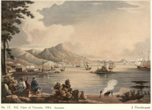
1843
1844
Comments
re: East Point; Happy Valley
Great additions Annelise. FYI the Chinese village in photo 10 above is Wong Nai Chung village, present day Happy Valley. The current tram terminus now stands roughly in front of those houses, while the Wong Nai Chung Road must roughly track the stream shown.
East Point, Happy Valley photo 10
Thanks for identifying the village, 80sKid. Does anyone know what happened to the stream in that photo? Does it now run underground, and does it come to the surface at any point?
Re: Wong Nei Chung
Hi there,
Back in the Mid-to-Late 1960's and before, part of that stream was not covered. I believe it was shown in one of those older photos posted somewhere in the gallery here. It want along the modernday Morrison Hill Road, then along Canal Road out to the sea. Even before the flyovers were built, part of Canal Road was not covered as well.
My 2 cents.
T
East Point photo captions
A couple don't look quite right to me.
#10 - 80skid, the hills don't look right to me for the tram terminus. There's still a chunk of flattish land behind the terminus, but in this photo the hills rise up quite quickly. And if the 1868 date is right, wouldn't we see the racecourse on the right? I don't have any better suggestions though - what do you see in the photo that points to the tram terminus area?
#17 - I think we're further west. Didn't East Point have piers and a sea wall, rather than a beach? Looking at the boats in the foreground, could it be the old V.R.C.? Then Navy land behind that, and Morrison Hill in the distance under the PRO logo?
Captions from the PRO
The captions are from the PRO, but they got them from the albums the photos came in.
As to the village, there were several that can be seen on the 1880 map - including one at the base of East Point Hill and the original Tai Hang Village, that can be candidates for the photo.
re: Wong Nai Chung
Hi David, I know it doesn't look that much like Happy Valley, but I'd seen that photo before ;-)
I think they flattened the hills behind the village out in the 1920s, allowing for better development. The same photo is in the public library records and has the following description:
Wong Nai Chung Village, Happy Valley, Hong Kong Island, c.1870-75.
The charming neat village at the head of Happy Valley had been inhabited long before the British occupation of Hong Kong. This fine photograph shows well the symmetrical layout and the authentic traditional Chinese style of the buildings. The early beginning of racing, in 1846, and the establishment of the Race Course in front of the village, the subsequent building development of the Happy Valley, must have created problems for the little peaceful village. The final straw was the severe typhoon, in August 1923, which caused flooding and severe damage to the village. It was abandoned after that.
Here's a photo taken 1865 from presumably Morrison Hill showing the village ansd the race-course. Looks like the yellow muddy creek (Wong Nai Chung) is still there. I think the other photo of the village is probably earlier though than the date given.
http://hkclweb.hkpl.gov.hk/hkclr2/object?svc=objrtv&src=CM&itemid=HXXEY6YDWXTJZL0Q&pid=1&mime=image/jpeg
re: Wong Nai Chung
Thanks for the extra info. The comparison photo certainly shows the slopes behind the village are steeper that I'd have guessed, so thanks for clearing that up.
Regards, David
Close up photo
Close up of Wong Nai Chung village.
It was taken around 1869
HF
re: wong nai chung
thanks - that's an awesome photo. looks like it was taken in winter; appears very dry. I like the dog!
Jardine's Garden
Same angle, between East Point Hill and Leighton Hill, but a bit different than the one in the PRO
Credit: Wellcome Images, London http://images.wellcome.ac.uk/indexplus/result.html?_IXMAXHITS_=1&_IXACT…
New image of the Jardine Matheson compound
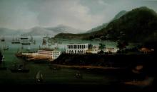
I recently purchased this watercolour, which was described as being:
"Vision of Cathay": British Installation on Hong Kong Island c.1841. It was also described as being by George Chinnery, but I believe this is unlikely, and the correct term would be "Circle of George Chinnery". Jardine Matheson have confirmed that this is their compound at East Point, (the building on the right). The building on the left confuses me; I thought it might be Flagstaff House, (on Flagstaff Hill), but I think that is more to the West, (and if it's the original), it's now in Hong Kong Park, and the Hong Kong Museum of Teaware.
East Point Hill
You are looking at #1 and #2 houses on East Point Hill from above toward the "north". Refer to this map:
http://gwulo.com/node/6237
I think you mean what appears to be a building beyond on a hill, which looks to me like an illusion caused by the angle of the painter.
Here is the view looking "east"
http://www.flickr.com/photos/46939376@N08/4585116069/
East Point Hill
Thanks for your reply. Are #1 & #2 Houses the offices or the residences of Jardine Matheson & Company?
Taipan houses. The Offices
Taipan residences. The Offices were at the sea level, where business was conducted. See photo 6 above.
Thank you so much for uploading such a high resolution image.
East Point Jardines
Hello all
Brilliant contempory prints & information
Is there any one out there that has similar info & prints of Mathesons home at Jardines look out(the site of pb1 of WW2 fame)
When was it demolished& why?
Regards
Gary Liddell
Matheson's bungalow
Hi Gary,
There's lots more about this house at: http://gwulo.com/mathesons-bungalow
No pictures yet though.
Regards, David
East Point Photo
David's comment on that supposed #17 East Point Photo. He's quite right. We're actually on top of the swimming enclosure near Palos Pier to seaward of Murray Barracks looking at the naval dockyard with its conspic truncated spire. The sheerlegs were on the end of the Pier to the top of which the Rifleman's Bolt level related via the tide gauge on its eastern, landward end. Beyond it is the Commisariat Pier.
Stephen D
Photo #17
Thanks Stephen, good to have that confirmed.
Regards, David
East Point photos 8 and 9
Can someone please enlighten me about where these two photos were taken, and to which direction the photographer was facing? I cannot seem to match them with possible current locations. Thanks!
Intersection of Percival, Hysan and Leighton roads
They were at the current intersection of Percival, Hysan and Leighton roads
Try the East Point Hill page. I've added a 1901 map with Gate and Garden labeled, and detail of the "photo zero" on this page.
http://gwulo.com/node/6240
.
Intersection of Percival, Hysan and Leighton roads
Thank you, annelisec. The map solved a little mystery of mine. I actually grew up in that area, and would never imagine that is where the garden was.
Jardine's 1844
A painting with the description "The East Point offices and godowns of Jardine's, newly built in 1844". Fits quite well with the 1844 map on Gwulo.
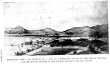
East Point + Jardine Matheson & Co. 1851
The legends in this left hand section of this 1851 lithograph for P&O read "East Point" and then "Jardine Matheson & Co., reading from left to right.
In the next section to the right there are two more buildings each labelled "Mathesons". I titled that section "Happy Valley" which is also shown. David included the section in his summary for this week.