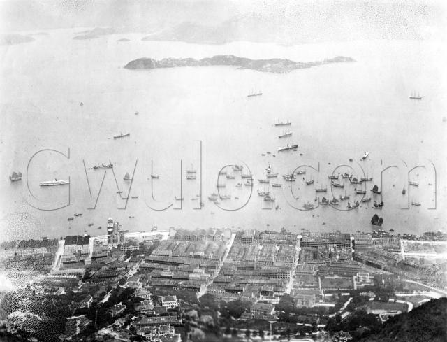
A view over Sai Ying Pun, and the western harbour towards Stonecutters Island. The photo is showing its age, but as this view wasn't photographed as often as Central and Sheung Wan, it's stilll worth showing.
It's from the same set as the photo of Union Church, and has the same person's handwriting on the back. On this photo it says:
"Hong Kong + Harbor from the mountain"
The spelling of 'harbor' suggests an American author. I guess it was taken from somewhere up the Peak. Today we'd think of Lugard Road as the likely spot, but that wasn't built yet when this photo was taken. So maybe it was taken from the very top of the Peak, as that lines up with the streets shown in the photo.
There are three long, parallel streets that are shown clearly in the photo. They run from the foreground downhill to the seafront. From left to right they are Western, Centre, and Eastern streets. Streets in Hong Kong often meet at all sorts of odd angles, so these are unusual in forming part of a large rectangular grid. The 'cross' streets of the grid shown in this photo are Connaught Road on the seafront, then moving back from the sea we have Des Voeux Road, Queen's Road, 1st, 2nd, 3rd, and High Streets.
In the foreground we catch glimpses of Bonham Road and Park Road. Neither of them look very heavily developed at this time.
Reference: A35B
Comments
View over Sai Ying Pun, 1900
Just to note that we have a huddle of lorchas and junks inshore, then steamships (all with awnings spread) further out and towards Stonecutters are a four masted and a three masted barque.
Richmond Estate
I recently bumped into this old photo of Hong Kong Island’s Sai Ying Pun area on the Gwulo website and realized that this photo also captures almost the entire Richmond Estate with all its original residential mansions. The Richmond Estate was located on the hillside of Bonham Road just above the Western and Centre Streets. The estate consisted of a number of majestic residential mansions built by the Richmond Terrace Estate & Building Company in the late 1800s. What makes this photo so rare is that it captures essentially all the Richmond Estate’s residential mansions with the exception of only one left out (Merton Lodge) in the lower left-hand corner of the photo and they were all originally built mansions. A lot of the originally built mansions were demolished in the thirties for the more practical 4 storey residential apartments. By the early seventies, all these mansions were demolished to give way for the modern high rises. The last Richmond Estate mansion demolished was Westbourne Villas. Strange enough, only half of this mansion was demolished in the mid-fifties and the remaining half stayed on until the early seventies. The second-to-last mansion demolished was Mount Richmond. It was demolished in the mid-sixties.
I expanded the original Gwulo photo and marked each mansion for ease of identification for the Gwulo readers.
A: Western Street, spanning from Sai Ying Pun waterfront to Bonham Road.
B: Centre Street, spanning from Sai Ying Pun waterfront to Bonham Road.
C: Bonham Road, connecting Caine Road in the east and intersecting PokFuLam Road in the west.
D: Craigellachie mansion
E: Westbourne Villas mansion
F: Edenhall mansion
G: Greenmount mansion
H: Stonybrook Cottage mansion
I: Richmond Terrace mansion
J: Ardmore Lodge mansion (blurred; original photo partially damaged)
K: Oaklands mansion (blurred; original photo partially damaged) (Because of its location, Richmond Estate built a private long footpath from Bonham Road to allow access to this mansion. Later on, when this development was turned over to the government, this footpath was further extended up to Lyttleton Road as a shortcut for pedestrians. This foot path was named Oaklands Path for obvious reason.)
L: Westley mansion
M: Hartley mansion
N: Eastley mansion (blurred; originally photo partially damaged)
O: Mount Richmond (only the roof is partially shown)
P: Rheda mansion (view partially blocked by Edenhall)
Q: Inglewood mansion