An early photo this week - we're off on a family vacation tomorrow, so I won't be here at the weekend to send it out.
If you can add anything about its "who / what / when / where", please can you let us know in the comments below? I look forward to reading them when we get back next week.
Regards, David
Reference: A244A
Date picture taken
1960s
Gallery
Shows place(s)
Comments
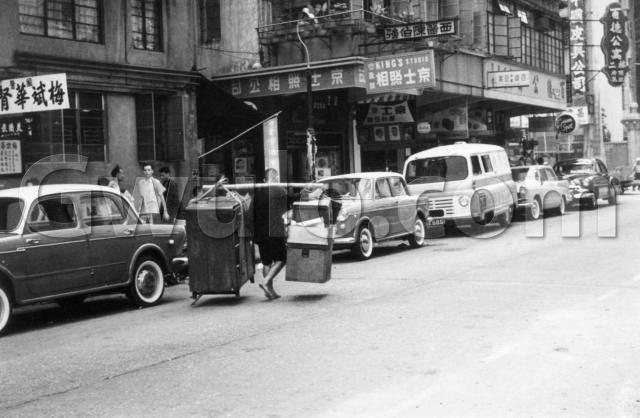
1960's Street Scene
Signs advertise Doctors - one a Chinese Medicine Kidney Specialist and another practising Western medicine. King's Photo Studio dominates the other advertising and there are signs for a couple of (seedy ?) apartment blocks and a leather goods shop. A sign on the rather drab, perhaps official building on the left says 561 Shanghai - so there's a good chance it's 561 Shanghai Street - which would take us well into Mongkok.
Street signs above the Green Spot advert and on the back wall are blurred, but the distinctive pillar set in the wall to the far right of the picture may give a clue ?
Vehicles are all parked facing the same way on their 'wrong' side which may indicate it's a one-way street, and if I recall correctly, Shanghai Street was one-way southbound in the 1960's.
I don't remember any similar wall or pillar , but my guess is - and it's definitely a guess - Shanghai Street, Mongkok, looking north towards the junction of Shantung Street.
H.
I found that the second last
I found that the second last car was not parked on the same direction.
I found that the second last
If you refer to the car between the van and the black American car, it appears to me to be in the same direction as the others?
The registration of Clinic
Regarding the registration record in '60, Clinic of Dr. Chan Pak Keung was located in 2/F, 1 East Point Road, Causeway Bay.
Another sign at the most right in vertical, "中國皮具公司" (China Leather Comapny") which was located in 545 Lockhard Road.
These two records allow us to pin point the exact location already. These buildings are now the Sogo Department Store, and taken at East Point Road.
Re: 1960s Street Scene
Hi there,
Some points to ponder:
1.The Green Spot sign would seem the prompt the photo is post 1950 throuth 1960s;
2.Some car experts might be able to figure out a period closer to the manuacturing years of them;
3.There are actually two T-shape street signs in the photo, but characters are not visible;
4.The 561 number on the sign actually 561 三樓. (3rd floor). If 561 is infact a street number, then the location could be narrow down to just a handful of streets. Still, no solid clues showing exactly where;
4a.A note on how local Chinese count the floors traditionally. We usually calls it Ground floor, second floor, third floor along the way up. That is, in our sense, Ground floor is equivalent to First floor. Confusion arises when high-rise and Lifts (or Elevators in the States) become daily necessity after WWII. There might still floor signs in older building where the Chinese and Roman numerials do not match up. For example, you may have one saying 2/F in English but the Chinese version says 三樓 (3rd floor).
5.King's Studio. I Googled it and found there is a current business in Prince Edward Road, Kowloon City, bearing the same name. No business signs visible in Street View though;
6.Don't know if there was a central registry for Medical Practitioners back then or we should be able to look up Dr Chan Pak Keung (西醫陳伯強) as shown in the photo;
Thanks & Best Regards,
T
All the cars are pointing in the same direction
All the cars are facing towards us.
including the first car, where the front doors open the wrong way (suicide doors).
Re: 1960s Street Scene
Hi there,
If this is the case, the pillars are of the gates of the then Jardine Matheson Godown right at East Point with the noon gun within. Actually I suspect the 百德公寓 was a hijack of the Paterson Mainsion (百德大廈) near by in Paterson Street.
Thanks & Best Regards,
T
re: Jardines gate
looks like a match. check this photo here of the pillars
http://racingmemories.hk/photogallery/1870-1880-jardine-matheson-co-s-p…
and this from hkmemory.org:
In 1923, Jardines sold East Point Hill to the Lee Hysan family. The hill was renamed The Lee Gardens, and Jardines moved the stone gate to Causeway Bay as its warehouse entrance. Under the Lee’s, the hill was developed into The Lee Gardens Playground, and the tai-pan mansion became a Chinese-style restaurant for touristic use. In the 1970s The Lee Gardens Hill was levelled, so forming what we see of the area today. When the Causeway Bay warehouse underwent reconstruction in 1972, Jardines sent the stone gate to Royal Hong Kong Jockey Club as a gift. Thereafter the gate was relocated to the main entrance of HKJC’s Beas River Country Club in Sheung Shui, renamed Yee Wo Gate.
Re: Photo
Interesting. If it is indeed Lockhart Road and Jardine Gate but what is the side street in the background?
Re: Photo
Hi there,
It would seem, the photographer was standing at the corner of East Point Road and Great George Street, facing NNW. The side street besides the gate would be Lockhart Road.
Thanks & Best Regards,
T
re: Photo
my guess is we're looking down Lockhart Road towards East Point Road, with the godown facing us. The part of East Point Road heading off to the left is no longer a road, while modern-day Sogo is off to the right, out of sight.
Here's the street view today: http://goo.gl/6R9bFE
Thanks
Thanks, got the bearings right now!
Re; East Point Road
Hi there,
The last stretch of Lockhart Road from Cannon Street to East Point Road is still a road from midnight to noon on weekdays, I think.
Thanks & Best Regards,
T
re: East Point
Hi T, I mean the stretch of East Point Road heading north to Excelsior. Also Chee On Building was completed in 1972, around the time Jardine's godown was demolished, so I assume was built on the same site. See: https://gwulo.com/node/19644
1960's Street Scene
Oh dear - well, Shanghai Street was just a guess !
H.
Re: East Point,
Hi there,
Ah, I see what you mean now. That section beneath Yee On and Chee On Buildings is no longer a street for vehicles since their inauguration in the 1970's.
The pass through from Jaffe Road to the Excelcior had been marked as a private street now and only authorized vehicles going to the hotel or the WTC are allowed. They have reinstated a gate with security guards about two years ago.
Thanks & Best regards,
T
1950s Causeway Bay
Date is a guess.
Thanks for the work
Thanks for the work identifying this one. I'd also guessed it was somewhere in Kowloon too, so I was way off.
I've made a Place for the gates, https://gwulo.com/node/19702, and put it where Lockhart Road meets East Point Road. Does anyone remember seeing it there? It doesn't appear in Moddsey's aerial photo of the area in the 1950s.
I'm not 100% sure the stretch of road shown above is Lockhart Road. When I look at Centamap, it shows the buildings along Lockhart Road between Cannon Street and East Point Road were all built in 1955, I guess after the clearance work in the aerial photo had finished. And if I look at that section in Google streetview, all the buildings look the same. But in the original photo at the top of the page they look different, with some set back and some extending out over the pavement.
Regards, David
Re:The East Point Gate
Hi there,
I could only remember it had become a metal gateway made of plates in the 1960''s. There were two Gates. One at East Point Road facing N/S, and the other at the end of Jeffe Road. I believe part of the wall is still there at Jaffe Road.
I don't remember the Arch though.
Thanks & Best Regards,
T
That is certainly from East
That is certainly from East Point Road as the shop next to "中國皮具公司" (China Leather Comapny") was called Chung Hing Company "昌興窗簾帆布" . That was a shop owned by my family. Only part of the sign of 昌興 is shown in photo.
And whoever photoed this, Thank You. My family members did not leave much record of this shop and we have searched witnesses for many years.
East Point Road
Looking at aerial images from the 1960s, it's possible to see what looks to be the Jardines gate located at the northern part of East Point Road just north of the junction with Lockhart Road. Essentially where the covered section starts today between the Chee On Building and 545 Lockhart Road (the last section of the block). So, this would concur with Vinnie's comment above (and T's first assertion) that we are looking north along East Point Road from somewhere near to the corner with Gt George St. This also tallies in with 80skid's earlier comments about the construction of the Chee On Bldg coinciding with the year the gates were donated/moved to Beas River.
The buildings on the left are where the Sogo building now stands and the road at the back is Lockhart Road.
I *think* that Moddsey's 1950's image, linked above, does show the gate at the top of East point Road but it is very well camouflaged in amongst the trees. You can just seethe top of the gate poking up through the trees.
Jardine's Stone Gateway (2nd Location)
A photo confirmation of the location of the stone gateway. The current Google Street View of the scene below.