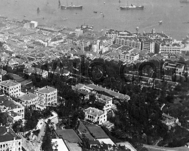
Where: The photographer was up near the Peak, looking down across Mid-levels and the Botanical Gardens to Central and the harbour.
What: We'll work our way clockwise around the photo, starting at 12 o'clock, directly above the 'o' in the middle of the watermark.
There we see the roughly-finished end of a building that is taller than most around it. Zoom in, and you'll see there are many long poles (probably bamboo) propping it up.
The tall building is northern section of the Hong Kong Hotel. It ran along Pedder Street from Queen's Road to Des Voeux Road. Here's the northern section as seen from the harbour side, shortly after it was finished:

In the main photo above, the poles were needed because the last 'old' section of the hotel had recently been demolished for rebuilding. It stood on the corner of Pedder Street and Queen's Road Central.
This was only one of several building projects that were changing the appearance of Central. Look above and to the left of the hotel and you can see the site where the new General Post Office is under construction. Here's what it looked like when it was finished:

Now swing around to the 1 o'clock position, and a group of buildings with patriotic namnes that dominated the 1906 Central skyline. They were still new when this photo was taken.
Looking left to right along the new seafront, we have:
- Hotel Mansions [1905, later renamed Union Building]
- York Building [1905]
- King's Building [1905]
- St. George's Building [1904]
- <Ice House Street>
- Queen's Building [1899]
Then one row nearer to us, between Des Voeux Road and Queen's Road, are:
- Alexandra Building [1904, the triangular building]
- King Edward Hotel [1902]
- <Ice House Street>
- Prince's Building [1904]
Ice House Street was the site of the Star Ferry pier:

In the main photo we can't see the pier itself, but you'll see one of the old-style Star Ferry boats arriving, and another on its way over to Tsim Sha Tsui.
Move round to 3 o'clock and the Governor's residence and ballroom are visible under the 'm' of the watermark.
The next stop is 4 o'clock, and the Gardeners' Cottages in the bottom-right corner. (This is the area we were looking at in the recent discussion about the bridge over Bowen / Macdonnell Road.) The gardeners had an easy walk to work - the open area above the cottages is the Botanical Gardens.
Down to 6 o'clock, and the bottom of the photo shows the tennis courts of the Ladies Recreation Club (LRC). We also have a photo of almost the same view taken in 1886. It's worth a look to compare the views, and see how much had changed in twenty years.
Also at the 6 o'clock position, is the long roof of The Albany. It was built in the 1840s, so is likely the oldest building in the main photo.
To the left of, and above the LRC courts are two roads that had me confused. After looking at a map, I think we've got Peak Road and May Road running next to each other. May Road runs closest to the LRC. In the foreground of the photo it looks unfinished, as though it is still under construction? Then in the distance it crosses over a bridge, and runs between two of the buildings of the Queen's Gardens development. The section of road from the bridge onwards was also known as "Queen's Gardens", but today it's called Hornsey Road.
To the left of May Road is the Peak Road. On the left of the photo it runs out of sight behind a building. It carries on up to The Peak. Following it downhill it runs under the May Road bridge, and meets Robinson Road a little further down the hill.
Peak Road is the busiest part of the photo, and from their shadows it looks as though several people are carrying goods up the hill on shoulder poles. That would have been hard, hard work.
Several readers are experts on the old mid-levels buildings, so I'm hoping they'll jump in to identify some of the other buildings in the lower-right corner of the photo. But I will point out what looks like another tennis court under the 'G' of the watermark.
The top-left corner is a densely-packed mass of smaller buildings. I'll welcome any you can identify among them.
The last landmark is back near the 12 o'clock mark, it's the Pedder Street clocktower (Note that the photo below also shows Hong Kong Hotel on the left. In this photo the old four-storey, southern section of the hotel has not been demolished yet):

When the clocktower was built it stood tall above the surrounding buildings, and I believe I've read that its light was used at night to help boats find their way to the Pedder Street pier. But by 1906 it was no longer the tallest landmark, and it only lasted a few more years until 1913. By then it was considered 'a serious obstruction to traffic', and was demolished.
When: It comes from a collection of photos that are mostly dated around 1906. But if you can see anything in the photo that contradicts that date, please let us know in the comments below.
Who: The only people to see are those toiling up Peak Road. But there are some people out of sight I'm interested to know more about - the people that originally owned this collection of photos. You can click here to see the other photos from the same collection.
So far we know :
- they were in Hong Kong around 1906
- there was some connection with the dockyard extension work
- the wife played tennis
From the jurors' lists we've seen that the Punchard & Lowther company worked on the dockyard extension. So I'm guessing the photos belonged to the family of a senior member of Punchard & Lowther, in Hong Kong to work on the Dockyard Extension project, and that the wife may have been a member of the LRC. I'll come back to this as we see more photos from their collection.
As always, questions, comments and corrections are very welcome - just leave a note in the comments below.
Regards, David
Reference: BA059A
Comments
"Tennis court" under the "G:
1. "Tennis court" under the "G is the garden of the Blue Bungalow (a bit seen at the left)
2.Yes, Peak and May Roads. When Queen's Garden was rebuilt after war, the road alignment at the entrance to Queen's Garden was changed a bit. No through road right-of-way needed for the new Govenment Flats.
Re: Date of photo
In 1907 May Road between Magazine Gap Road and Peak Road at Queens' Gardens was in the course of construction. In the same year, the road leading from Queen's Gardens to Conduit Road was opened to traffic and simply called Queen's Gardens. It was subsequently renamed Hornsey Road.
Date of photio ;-)
Ah, 1906, I was wondering about the date, the same picture is on the library site
1) dated 1930s ;-)
2) printed the wrong way round ;-)
Do you know when the road was renamed Hornsey road?
Assuming that the May Road bridge hasn't moved,
the current Hornsey road is 90ft closer to the sea, than in this picture.
Re: date of photo
BTW, could you advise the search reference on the library site for the same photo?
Yes, there was an adjustment in the road after the road was renamed Hornsey Road. At this juncture, am unable to pinpoint the date but believe the road name was changed after WWII.
See: http://gwulo.com/node/8926
Star Ferry pier
Does anyone know when the Star Ferry pier was moved to the end of Ice House Street?
Re: Star Ferry Pier
From Gwulo: http://gwulo.com/pedders-wharf-post-1886
http://gwulo.com/node/5122 and http://gwulo.com/node/5177
Corrections
Annelise - Thanks for identifying the Blue Building's garden. Do you think it was laid out as a tennis court at this time? It looks as though there are nets set up around its edge.
Moddsey - It could well be 1907. We'll see if there are any more confirmations for that. Hornsey spelling corrected.
Jabber Jabber - You're right, Star Ferry was at Ice House Street in this photo, not Pedder Street. Corrected.
Thanks for the help,
David
on the Library Site
@Moddesey,
On the library site,
http://hkclweb.hkpl.gov.hk/hkclr2/internet/eng/html/welcome.html
take the basic search option, check "photo", and keyword "disaster".
It's in a group "old H.K. Disaster pictures" - there "could" be a landslide behind the house on May Rd / Peak Rd, but it looks like earthworks to me.
and it's changed the date to 18?? by magic ;-)