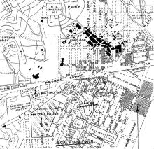
The marker shows the approximate location of Ping Street. It was a short street that ran NNE from Kau Pui Shek Road to Boundary Street.
Ping
On a current map, the only streets even remotely close to the Kowloon City area with 'Ping' are 'Ping Ting Road 平定道' and 'Ping Ting Road East 平定道東' in present day Ngau Chi Wan. Both seem to be a little bit above sea level, next to Hammer Hill Road, and quite close to 'Ping Shek Estate 坪石村'.
Or could it be one of the roads that got erased when the airport was extended later on?
breskvar
Re: Ping Street
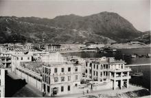
Ping Street was in Kau Pui Shek, Kowloon City. The street no longer exists. Most likely it was erased when the Japanese built the twin runways at Kai Tak during the war.
The only remnant of Kau Pui Shek is the CLP sub station under the flyover near the Kowloon City roundabout.
Re: Ping Street
According to a Chinese web page on disappeared streets of Hong Kong, Ping street was among several streets that commemorate Emperor Bing, whose travelling court was in the Kowloon region in 1278. These streets include Sung Street, Tai Street, Ping Street ("Sung Tai Ping" means Emperor Ping of Sung [Dynasty]), Wong Tai (yellow emperor) Street, Ching Lung (green dragon) Street , Wong King (Reeves's muntjac) Street, Koo Chick (historical site) Street, Sing Ti (holy place) Street and Ki Lim (commemoration) Street.
1930s Kowloon City Street Map
Ping Street was situated near the Sacred Hill (Sung Wong Toi).

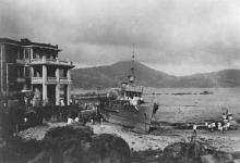
(The photos of the beached ship Hai Chow were all taken around Ping Street.)
Photos that show this Place
Ping Street
The 1936 newspapers mention the ship ran ashore near Ping Street, Kowloon City. I see a lot of "Ping <something> Street" in the modern map books, but no plain "Ping Street". Does anyone know where it was?
Regards, David