Terrific Herostratus. I should have found this ages back.
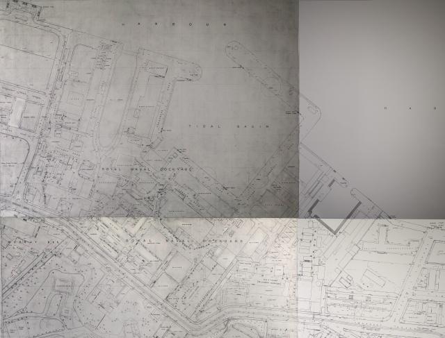
This excellent map proves what I have long suspected. This is that the 'pier' (i.e. mounting for the transit instrument) of the US Navy telegraphic determination of longitude expedition of 1882 survived until the shrinking of the naval dockyard with the building of Harcourt Rd in c.1961-62. (The whole USN exercise began in the West Indies in 1874 and ended in 1882 when the ships got back to the Atlantic having checked the longitudes of 33 locations.) The "Old Hong Kong" column in the SCMP of 27 October 1933 noted that the 'Palos Pier' (named after the USS Palos) had been preserved and turned into a sundial, with a commorative plaque reading,
Observing Station
U.S.S. Palos
1881
Lat. 220 16’-58”.19 N
Long. 1140 09’ – 42”.75 E
There was a picture with the article.
A 1949 aerial photo shows that the pier had pretty certainly survived the Japanese Occupation, but this plan confirms it. Palos Pier is here mapped as "monument" just inside the West Gate.
It must then have been bulldozed, along with everything else bar the North Barracks building (which didn't last that much longer), in order to provide the fill for the old dry dock.
Comments
Palos Pier
Terrific Herostratus. I should have found this ages back.
This excellent map proves what I have long suspected. This is that the 'pier' (i.e. mounting for the transit instrument) of the US Navy telegraphic determination of longitude expedition of 1882 survived until the shrinking of the naval dockyard with the building of Harcourt Rd in c.1961-62. (The whole USN exercise began in the West Indies in 1874 and ended in 1882 when the ships got back to the Atlantic having checked the longitudes of 33 locations.) The "Old Hong Kong" column in the SCMP of 27 October 1933 noted that the 'Palos Pier' (named after the USS Palos) had been preserved and turned into a sundial, with a commorative plaque reading,
Observing Station
U.S.S. Palos
1881
Lat. 220 16’-58”.19 N
Long. 1140 09’ – 42”.75 E
There was a picture with the article.
A 1949 aerial photo shows that the pier had pretty certainly survived the Japanese Occupation, but this plan confirms it. Palos Pier is here mapped as "monument" just inside the West Gate.
It must then have been bulldozed, along with everything else bar the North Barracks building (which didn't last that much longer), in order to provide the fill for the old dry dock.
Best,
StephenD