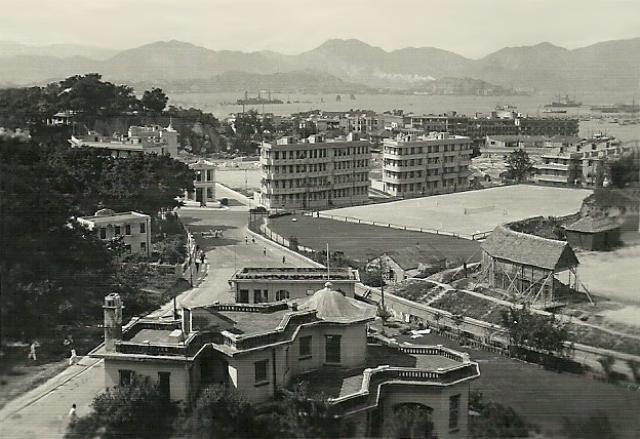
Somewhere along the north shore of HK island, to the east by the look of it. Any ideas?
Regards, David
Source: This image came from Flickr, see https://flickr.com/photo.gne?id=8108727355
Date picture taken
1940s
Gallery
Shows place(s)

Comments
Guess
Hi David,
Just using a modern map to align Lion Rock and Tai Wan Hill in Hung Hom (what is the proper name?) for an approximate location. It is somewhere in Causeway Bay. Perhaps between Caroline Hill and Happy Valley? I can't help with the buildings though.
breskvar
Somewhere up in Link Road
Hi there,
I think I've got it. The sloping road by the left was Link Road, joining Caroline Hill road right in the middle of the photo. Right at the junction was Leighton Road, with the old Zoroastrian building right there. This is how I nailed the locaiton.
You may also see the Lee Garden Hill is partially still there. I think by the left was one of the early buildings of the Po Leung Kuk.
A bit more information. The playground in the foreground used to be the Cable & Wireless Sports Club. It become the Hong Kong Telephone Sports Club soon after Cables & Wireless is no more. Now it is running under HKT under PCCW. The retaining wall is still there.
My 2 cents,
T
Location confirmed.
Yes, T has got the location spot on.
Thanks Thomas, I've just let
Thanks Thomas, I've just let the Flickr poster know too.
Regards, David
Link Road & Caroline Hill Road
Hi there,
I hope someone could recognize the big house in the foreground. Despite the Pavilion type of roof it was not a traditional Chinese House. Traditional Chinese houses like those in the remaining villages do not have chimneys like the one in the photo. The chimney was a western element.
Best Regards,
T
Re: Link Road
The house seems to have been situated at the present-day No. 3 or, less likely, No. 5 Link Road. In the 1970s, No. 3 was part of the New Method College and No. 5 was a 5-storey residential building (possibly built in the 1950s). Both looked nothing like the house, and both were demolished in mid- to late 1980s.