I've walked along Tai Tam Reservoir Road, on the shore of Tai Tam Tuk Reservoir, many times, but until a few months ago hadn't noticed the structures just to the east of the last masonry bridge before the road starts climbing into the hills.

A few weeks ago, just before the Reservoir filled-up with the recent rain, I went back for a closer look. The easiest access is via the path that runs to the base of the dam wall of Tai Tam Intermediate Reservoir from the southern end of the masonry bridge. It starts on the left in the following pic.

At the dam wall, double back along the stream bed, towards and under the masonry bridge.

Two short, matching, stone promontories face each other on opposite banks.

They're obviously the ends of a demolished bridge. As they are submerged when the Reservoir is full, the ruined bridge must pre-date 1918, the year Tai Tam Tuk Dam was completed.

A lump of concrete debris sits ontop of the north promontory.

It's obviously out of place. The concrete consists of small stones set in mortar, quite different to the large stone blocks of the ruined bridge, suggesting it belongs to another structure or was constructed at a different time. A metal bracket emerges from one side. More of this later.

Behind the bridge, at the edge of the nearby undergrowth, a cutting has been dug in the earth. It's probably the remains of the track that once crossed the ruined bridge.

Access to the south end of the ruined bridge is more complicated than to its north end. Retrace your steps to the top of the masonry bridge, and the entrance to the "Tai Tam Tuk Reservoir BBQ Area Site 3" on the right side of the third photo above. It's a large grassy area surrounded by a low fence. At the far end a rough path runs through the jungle to the bank of the Reservoir. It's overgrown and steep, but passable. Blocks of chopped trees cover the path at one point and scream "snakes", so make lots of noise and look out.
Once on the bank, the water level will determine if it's possible to walk around to the ruined bridge. Another word of warning here. The earth bank of the Reservoir is very steep in places, and rich in clay, so is extremely slippery when wet. From personal experience I know that, once you start sliding down, it's difficult to stop until you're in the water.
After a short distance you round a headland and see this.

It's basically a terrace dug into the slope with rear and side walls preventing soil subsidence. The walls are of concrete of similar consistency to the concrete block on the north end of the ruined bridge.

A narrow walkway runs along the front of the building. The only entrance is set in the low front wall, flanked by brick pillars.

The front of the structure is supported by a brick wall on top of a stone wall, the latter being almost submerged at the time of the visit.

The view from the other end looks like this.

A narrow crack in the side wall suggests ground subsidence. Closer inspection reveals that concrete of a different consistency to the remainder of the building was used to close a much wider gap, but then further subsidence seems to have occurred and the gap reopened.

All the walls are bare, giving no hint of the buildings original function. There's not even sufficient evidence to determine if there was originally a roof.

The south end of the ruined bridge is only a hundred meters further along the bank following the course of the old track.

A stone wall runs towards the masonry bridge. It was probably to prevent the erosion of the foundations of the ruined bridge in the days when a stream ran beneath it.

Obvious questions are, what is the unidentified building, and when was it and the ruined bridge built and in use?
A 1903 map ("City & Hill District Waterworks, Tytam-Tuk Scheme, Proposed New Road & Reservoirs" by W. Chatham" available in the Government Records Office) holds some of the answers. Sorry, I can't post it as I didn't pay the additional fee to do so. The map shows the Tai Tam area prior to the construction of the Tai Tam Intermediate and Tai Tam Tuk Reservoirs. The location of the unidentified building is marked with the caption, "Temporary Pump House & Dam Already Erected". A road runs over a bridge at the location of the ruined bridge.
The 1903 Report of the Director of Public Works, the same W. Chatham who signed the above mentioned map, contains more details. At Page 183, he wrote;
"In order to render available, until some permanent works could be established, the dry-weather flow of the streams, the water of which it is ultimately intended to impound, it was decided to construct a small dam and lay down temporary pumping plant, which would be capable of raising half a million gallons per day from the Tytam Tuk Valley to the gauge basin at the entrance to the Tytam Tunnel...a small dam immediately below the junction of the three principle branch valleys was constructed, a site for the engine and boiler was formed and a building to contain them and provide quarters for the engine-drivers erected; and a rising main 1 1/4 miles long was laid with such pipes as were available. All this work was successfully accomplished and the engine started work on the 1st November."
The Temporary Pump House didn't last long. The 1917 edition of the PWD Report noted that the temporary pumping plant had been "dismantled and removed in November 1915". Presumably the then new pumping station that still stands today on the shore of Tai Tam Bay took over its function.
To summarize, the ruined building was a water pumping station used from 1903 to 1915 to pump water from a small reservoir that existed before the Tai Tam Tuk Dam was built. I've not been able to find a date for the construction or demolition of the ruined bridge. It must have been bult before 1903, as it's shown on the 1903 map, and was probably demolished sometime between 1903 and 1918 when the Tai Tam Tuk Reservoir waters rose and eventually submerge it during the rainy seasons. I wonder if the wall of the small dam was also demolished, or is it still there lying beneath the deep waters of the Reservoir?
And the concrete block ontop of the north end of the ruined bridge? Could it have been part of a support for the "rising main" water pipe as it crossed the stream that flowed under the ruined bridge? The semi-circular shape of its metal bracket is certainly appropriate for carrying a pipe.
Comments
Old Dam at Tai Tam
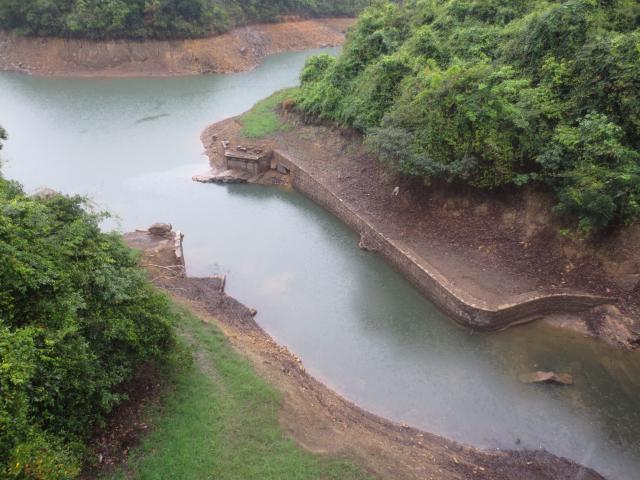
As mentioned in the last post, in 1903 a small dam and a pump house were built at the northern end of the Tai Tam Valley. Both were intended as temporary structures to collect water until the much larger Tai Tam Tuk Dam was constructed. A May 2014 visit to the site found the ruins of the old Pump House, but there was no sign of the small dam and I wondered if it had been demolished or was still present out of sight beneath the waters of the reservoir. With the end of the dry season approaching, I went back to see if the low water levels had revealed any evidence of the small dam.
It's still there!
This is the view from the south-west side. The dam is the wall in the middle. To its right, the downstream side, are the waters of the Tai Tam Tuk Reservoir - two to three meters lower than when I last visited. On its left, the upstream side, is where the actual reservoir once was, now completely filled by earth and rocks washed down by the feeder streams.
It seems to be a simple stone wall with buttresses at each end. Here's the view looking back along it from the eastern end.
The last pic shows all four of the old structures in the vicinity. On the left is the dam with the ruins of the Pump House above it. On the right is the most northerly of the masonry bridges carrrying the road along the west side of Tai Tam Tuk Reservoir. Below it are the ruins of the old bridge that carried the old road through the valley before it was flooded by the Reservoir.