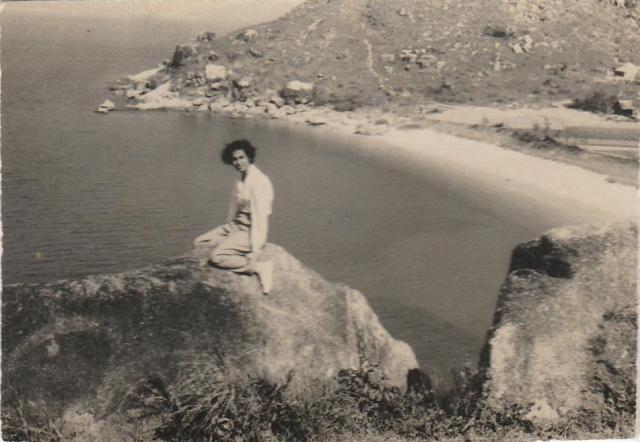
There aren't so many beaches that big around with flat fields behind and a hill overlooking them like this. I don't see a possibility on Cheung Chau. Could it possibly be just a short ride over the water at the Tai Long Wan on the Chi Ma Wan peninsula? The viewpoint would be up on the on what is now the Chi Ma Wan Country Trail between marker posts C1420 and C1421 (now surrounded by bushes and trees). I note also the colouration of the water which suggests a stream entering the sea bringing down silt at the end of the beach nearest the camera. That also fits with the beach I'm suggesting.
But this is just an idea - I'm not sure by any means.
Oh, that's interesting: I especially like the detective work re: colour of water. Yes, I had had the same thought about whether there was a beach large enough on Cheung Chau. Thanks for the details of the possible viewpoint. I'm not in HK but should be back next summer, and perhaps will be able to walk that trail.
If looking at the 95 years old aerial photo ( Nov 1924 ) over cheung chau, there is an area would fit the landscape perfectly. Along the western coast of the north CC island. you see two beaches and rocky reef area.
That is it..... the bigger beach along the North Cheung Chau Waterway, a very quiet beach facing the bank of the Chi Ma Penisula of the Lantau Island.
There was a farmer's field, they mainly grew long grasses and some easy growing vegetables, which are produces to be sold on the local marketplace. The beach's name is Tai Gua Wan ( means Big Ghost Bay in the old days. Many local youths would come here for picnic. It is a place you can make lots of noices, without any complaints.It was quite remote from the nearest habitat. Today there is a housing village on the foothill, which is also within the view from the christians cementry. up above near the ridge.
The lady's location is therefore on a higher site by the Shui Gua Wan ( means Little Ghost Bay) which is much smaller and always had dozens of small fishing boats or Junks residing. Today, I think, part of which plus extra reclamation, forms the site of the waste water treatment plant.
The background hill remains to be the highest hill on the CC island even its top was cut shorter, in the 1970s, for the equipment site of the air traffic navigational facility.
If you take a ferry ride to Cheung Chau, once you pass the light beacon on the Adamastor Rock by the North Cheung Chau Channel or Waterway, There are two beaches of CC you can see.
It is the first of the two beaches you can see before the ferry coming into the wave-breakered harbour today. The next beach is about 50% smaller, Further on appeared the waste water treatment plant. Then comes the left-turn toward the entry to the CC town harbour.
The rock heads by the lady in the picture may be gone due to land development. It was on a rise-up between the two beaches.
BTW today the cantonese name of Tai Gua Wan has been changed to Big Expensive Bay! No more Ghost!!.............. Really?
Comments
Hmm... tricky!
There aren't so many beaches that big around with flat fields behind and a hill overlooking them like this. I don't see a possibility on Cheung Chau. Could it possibly be just a short ride over the water at the Tai Long Wan on the Chi Ma Wan peninsula? The viewpoint would be up on the on what is now the Chi Ma Wan Country Trail between marker posts C1420 and C1421 (now surrounded by bushes and trees). I note also the colouration of the water which suggests a stream entering the sea bringing down silt at the end of the beach nearest the camera. That also fits with the beach I'm suggesting.
But this is just an idea - I'm not sure by any means.
Beach on Cheung Chau?
Oh, that's interesting: I especially like the detective work re: colour of water. Yes, I had had the same thought about whether there was a beach large enough on Cheung Chau. Thanks for the details of the possible viewpoint. I'm not in HK but should be back next summer, and perhaps will be able to walk that trail.
Why not?
https://gwulo.com/atom/30756/zoom
If looking at the 95 years old aerial photo ( Nov 1924 ) over cheung chau, there is an area would fit the landscape perfectly. Along the western coast of the north CC island. you see two beaches and rocky reef area.
That is it..... the bigger beach along the North Cheung Chau Waterway, a very quiet beach facing the bank of the Chi Ma Penisula of the Lantau Island.
There was a farmer's field, they mainly grew long grasses and some easy growing vegetables, which are produces to be sold on the local marketplace. The beach's name is Tai Gua Wan ( means Big Ghost Bay in the old days. Many local youths would come here for picnic. It is a place you can make lots of noices, without any complaints.It was quite remote from the nearest habitat. Today there is a housing village on the foothill, which is also within the view from the christians cementry. up above near the ridge.
The lady's location is therefore on a higher site by the Shui Gua Wan ( means Little Ghost Bay) which is much smaller and always had dozens of small fishing boats or Junks residing. Today, I think, part of which plus extra reclamation, forms the site of the waste water treatment plant.
The background hill remains to be the highest hill on the CC island even its top was cut shorter, in the 1970s, for the equipment site of the air traffic navigational facility.
Tung
Tai Gua Wan of Cheung Chau
If you take a ferry ride to Cheung Chau, once you pass the light beacon on the Adamastor Rock by the North Cheung Chau Channel or Waterway, There are two beaches of CC you can see.
It is the first of the two beaches you can see before the ferry coming into the wave-breakered harbour today. The next beach is about 50% smaller, Further on appeared the waste water treatment plant. Then comes the left-turn toward the entry to the CC town harbour.
The rock heads by the lady in the picture may be gone due to land development. It was on a rise-up between the two beaches.
BTW today the cantonese name of Tai Gua Wan has been changed to Big Expensive Bay! No more Ghost!!.............. Really?
Tung
Re: 大鬼灣
Hi Tung,
Despite I am not a Cheung Chau local, once I know the original name of that location I had been calling it 大鬼灣 since.
T