The arches still exist. That section of Bowen Road had not changed much. The slopes on both sides is much over grown these days. However if you use Google Earth to zoom in after changing the orientation, you should be able to see some of the arches.
I walked the full length of it a few times last year. Sort of crowded at certain time of the day. Some of the minor stone\brick works could still be seen if you know where to look for.
T
ps. screen capture from Google Earth after changing North\South orientation and zooming in.
Thanks for confirming this - it's good to know. The few photos that I could find online suggested that at least some of them were still there, rather than built over/filled in, but as you say, the trees must have grown so much that they are hard to see in most places. Perhaps some of the apartment blocks or lower roads in Mid-Levels have a view back towards Bowen Road and the arches might be partly visible from them. I'll have a closer look on Google streetview.
This photo on the AMO website is an example of some overgrown arches on the Tai Tam conduit, but I'm curious to know where it was taken. The immediate vicinity doesn't look very built-up.
This is a great, clear picture - thanks for posting it. This section of the structure at least looks to be in good condition. I can see why it would not be easily visible from a distance, with those trees growing so well nearby.
Thanks very much for taking these photos showing the current condition of the conduit and staff quarters. Another question - is it still possible to walk along the top of the conduit all the way from the end of Bowen Road around to the reservoir?
You can walk on the top from Magazine Gap Road to Stubbs Road. Total distance is 4km, it's a very popular jogging route for Islanders. Near Stubbs Road, you can see the big duct just on the right of the path. If you need to go to Tai Tam, you will then need to walk on Wong Nai Chung Gap Road, but I am not very sure if there's foot path next to that connection section between Stubbs Road and Wong Nai Chung Gap.
The last section of Bowen Road on Stubbs Road side had been rebuilt. The government had not demolished the old viadut. Instead a new section was built upon it. That, I believe, had something to do with the slope and\or the Stubbs Road flyover across the roundabout.
I believe the viaduct is no longer in use since the Albony filter bed is long gone. The viaduct between Tai Tam Reservoir and Tai Hang Road had been a tunnel (as mentioned by Klaus in another thread). I believe the tunnel is still in use but its destination become Eastern Water Treatment Works right next to the Stubbs Road Roundabout.
T
Map showing Tai Hang Road exit of viaduct tunnel captured from Geoinfo Map
I also enjoy my long weekend walks along Bowen Path and when time permits have been researching the internet to find old photos, postcards, and plans of the original Bowen conduit/ aquaduct from the late 1800s to the 1920s, when the road systems near Wong Nai Chung Gap were significantly expanded. The old Tai Tam Reservoir tunnel outlet structures (two of which are heritage structures: Grade 2 Historic buildings) which used to provide the source water for the Bowen conduit/ aquaduct are still there along Tai Hang Road and tucked behind a Towngas distribution depot. Unfortunately, WSD and ASD have done a poor job of maintaining these amazing old granite tunnel outlet structures and have the area fenced-off with barbed wire, even though along Tai Hang Road (across the street from the Marymount School) there is a nice WSD historic plaque, "Tunnel Outlet and Stone House of Tai Tam Reservoir". I will try to post a photo of this.
There are two aspects of the original late 1880s Bowen Conduit/Aquaduct that I am having alot of difficulties finding accurate information on and old photos;
1. What was the exact routing of the conduit/aquaduct from the Tai Tam Reservoir Tunnel outlet across the Wong Nai Chung Gap valley over to where Bowen Path curently starts? One old road plan that I have been able to locate from the late 1800s indicates that the raised aquaduct ran more or less parallel with the north slope in front of the upper Marymount School (in line with current day upper Blue Pool Road) and then across to the junction with Lower Stubbs Road/ current day start of Bowen Path. Another plan shows that the aquaduct ran more or less where Tai Hang Road eventually was built in the 1920s in this section, connecting to upper Lower Stubbs Road and Wong Nai Chung Gap road. However, I have yet to find any abandoned granite walls or arched foundation stones along this wide stretch of either upper Blue Pool Road and/or Tai Hang Road to the junction with Stubbs Road and Wong Nai Chung Gap Road.
2. Apparently there was once section of the original Bowen aquaduct that had to go through a tunnel section, due to the instability of that portion of the projecting steep sloped hillside. I suspect it is the portion of current day Bowen Path which is distinctly not flat; there is a section of current day Bowen Path (about 200 metres) which rises up and rises back down to where a very nice arched granite section of Bowen Path still exists today. This raised up portion of Bowen Path is not very far away from the old 1903 granite city boundary stone.
Does anyone have any relevant information on these two items related to the old Bowen conduit. aquaduct?
Dear Liz, noted and thanks. What I plan to do in the next few months, is to create an overlaid map of the current day Bowen Road/ Path versus the original hillside contours from the Tunnel outlet all the way to the Albany sand filter beds (which were located just on the other side of the Peak Tram line). This will hopefully advise if the original Bowen conduit/aquaduct is buried below the existing Tai Hang Road (which is level from the Tunnel outlet to the Wong Nai Chung Gap roundabout). More to follow.
"From the Tytam (sic) Reservoir, water is conveyed into town by means of a tunnel, a mile and one third in length and a conduit along the hillside some 400 feet above the sea level and nearly four miles in length, on which a fine road - called the Bowen Road - has been formed, which commands the most charming views of the city and the eastern district, and is a favourite resort of pedestrians In many parts, the conduit is carried over ravines and rocks by ornamental stone bridges, one of which, above Wanchai, has twenty-three arches."
Source: The Directory & Chronicle for China, Japan, Corea, Indo-China, Straits Settlements, Malay States, Siam, Netherlands India, Borneo, the Philippines for 1909. Available online on Google Books.
Comments
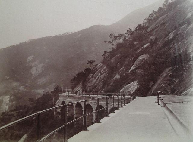
do these arches still exist?
I realise that the Tai Tam conduit still exists (at least in part), but does anyone know if the arches shown in this photo from 1900 remain?
I think so - there are
I think so - there are certainly lots of arches to see when walking along Bowen Road, though not sure if these exact arches have survived.
Re: Bowen Road Viaduct
Hi There,
The arches still exist. That section of Bowen Road had not changed much. The slopes on both sides is much over grown these days. However if you use Google Earth to zoom in after changing the orientation, you should be able to see some of the arches.
I walked the full length of it a few times last year. Sort of crowded at certain time of the day. Some of the minor stone\brick works could still be seen if you know where to look for.
T
ps. screen capture from Google Earth after changing North\South orientation and zooming in.
Arches etc
Thanks for confirming this - it's good to know. The few photos that I could find online suggested that at least some of them were still there, rather than built over/filled in, but as you say, the trees must have grown so much that they are hard to see in most places. Perhaps some of the apartment blocks or lower roads in Mid-Levels have a view back towards Bowen Road and the arches might be partly visible from them. I'll have a closer look on Google streetview.
where would these be?
This photo on the AMO website is an example of some overgrown arches on the Tai Tam conduit, but I'm curious to know where it was taken. The immediate vicinity doesn't look very built-up.
Re: Bowen Road Viaduct
Hi There,
That photo may have been taken using some soft of a very wide angle lens, probably a semi-fisheye or a full fisheye one.
It has to be on top of one of these buildings. Likely the twin towers in the middle. Ewan Court, I think.
T
yes, that's a possibility
and interesting to see this angle, thank you.
Liz
Yes. They still exist.
Yes. They still exist. Photo taken today.
Thank you
This is a great, clear picture - thanks for posting it. This section of the structure at least looks to be in good condition. I can see why it would not be easily visible from a distance, with those trees growing so well nearby.
Photos of conduit and Tai Tam Reservoir Staff Quarters
Amberone,
Thanks very much for taking these photos showing the current condition of the conduit and staff quarters. Another question - is it still possible to walk along the top of the conduit all the way from the end of Bowen Road around to the reservoir?
Cheers, Liz
Bowen Road
Hi Liz,
You can walk on the top from Magazine Gap Road to Stubbs Road. Total distance is 4km, it's a very popular jogging route for Islanders. Near Stubbs Road, you can see the big duct just on the right of the path. If you need to go to Tai Tam, you will then need to walk on Wong Nai Chung Gap Road, but I am not very sure if there's foot path next to that connection section between Stubbs Road and Wong Nai Chung Gap.
Hope these help :)
Bowen Road
Hi Amberone,
That's interesting, and good to know, thanks. I'll make sure I check it out on my next visit to HK.
Liz
Re: Bowen Road, Stubbs Road side
Hi There,
The last section of Bowen Road on Stubbs Road side had been rebuilt. The government had not demolished the old viadut. Instead a new section was built upon it. That, I believe, had something to do with the slope and\or the Stubbs Road flyover across the roundabout.
I believe the viaduct is no longer in use since the Albony filter bed is long gone. The viaduct between Tai Tam Reservoir and Tai Hang Road had been a tunnel (as mentioned by Klaus in another thread). I believe the tunnel is still in use but its destination become Eastern Water Treatment Works right next to the Stubbs Road Roundabout.
T
Map showing Tai Hang Road exit of viaduct tunnel captured from Geoinfo Map
Bowen Road, Stubbs Road side
Thanks T, I was wondering about that section and how much of it was still in place and visible.
Cheers, Liz
Bowen/ Tai Tam Reservoir conduit 1880s
I also enjoy my long weekend walks along Bowen Path and when time permits have been researching the internet to find old photos, postcards, and plans of the original Bowen conduit/ aquaduct from the late 1800s to the 1920s, when the road systems near Wong Nai Chung Gap were significantly expanded. The old Tai Tam Reservoir tunnel outlet structures (two of which are heritage structures: Grade 2 Historic buildings) which used to provide the source water for the Bowen conduit/ aquaduct are still there along Tai Hang Road and tucked behind a Towngas distribution depot. Unfortunately, WSD and ASD have done a poor job of maintaining these amazing old granite tunnel outlet structures and have the area fenced-off with barbed wire, even though along Tai Hang Road (across the street from the Marymount School) there is a nice WSD historic plaque, "Tunnel Outlet and Stone House of Tai Tam Reservoir". I will try to post a photo of this.
There are two aspects of the original late 1880s Bowen Conduit/Aquaduct that I am having alot of difficulties finding accurate information on and old photos;
1. What was the exact routing of the conduit/aquaduct from the Tai Tam Reservoir Tunnel outlet across the Wong Nai Chung Gap valley over to where Bowen Path curently starts? One old road plan that I have been able to locate from the late 1800s indicates that the raised aquaduct ran more or less parallel with the north slope in front of the upper Marymount School (in line with current day upper Blue Pool Road) and then across to the junction with Lower Stubbs Road/ current day start of Bowen Path. Another plan shows that the aquaduct ran more or less where Tai Hang Road eventually was built in the 1920s in this section, connecting to upper Lower Stubbs Road and Wong Nai Chung Gap road. However, I have yet to find any abandoned granite walls or arched foundation stones along this wide stretch of either upper Blue Pool Road and/or Tai Hang Road to the junction with Stubbs Road and Wong Nai Chung Gap Road.
2. Apparently there was once section of the original Bowen aquaduct that had to go through a tunnel section, due to the instability of that portion of the projecting steep sloped hillside. I suspect it is the portion of current day Bowen Path which is distinctly not flat; there is a section of current day Bowen Path (about 200 metres) which rises up and rises back down to where a very nice arched granite section of Bowen Path still exists today. This raised up portion of Bowen Path is not very far away from the old 1903 granite city boundary stone.
Does anyone have any relevant information on these two items related to the old Bowen conduit. aquaduct?
Thanks,
James
Tunnel location and outlet
Hi James,
You will find more information on https://gwulo.com/node/51890. If you have any more details or photos to add, they're always welcome.
Cheers, Liz
Bowen/ Tai Tam Reservoir conduit 1880s
Dear Liz, noted and thanks. What I plan to do in the next few months, is to create an overlaid map of the current day Bowen Road/ Path versus the original hillside contours from the Tunnel outlet all the way to the Albany sand filter beds (which were located just on the other side of the Peak Tram line). This will hopefully advise if the original Bowen conduit/aquaduct is buried below the existing Tai Hang Road (which is level from the Tunnel outlet to the Wong Nai Chung Gap roundabout). More to follow.
Jim
The Tunnel, Conduit and Arches
The number of arches is mentioned hereunder.
"From the Tytam (sic) Reservoir, water is conveyed into town by means of a tunnel, a mile and one third in length and a conduit along the hillside some 400 feet above the sea level and nearly four miles in length, on which a fine road - called the Bowen Road - has been formed, which commands the most charming views of the city and the eastern district, and is a favourite resort of pedestrians In many parts, the conduit is carried over ravines and rocks by ornamental stone bridges, one of which, above Wanchai, has twenty-three arches."
Source: The Directory & Chronicle for China, Japan, Corea, Indo-China, Straits Settlements, Malay States, Siam, Netherlands India, Borneo, the Philippines for 1909. Available online on Google Books.