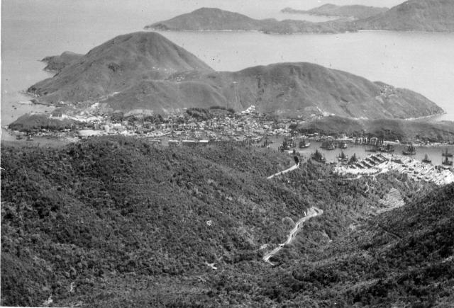
Probably taken from the Aberdeen Reservoir road. Ap Lei Chau was still largely undevelped. That would change when the bridge was built. (Andrew S)
Please see T's comment about the photogaph having been taken from Peel Rise. Andrew
Date picture taken
1953
Gallery
Shows place(s)
Comments
Re: Very likely somewhere up Peel Rise
Hi There,
The photographer was very likely somewhere on Peel Rise, above the catch water, which could clearly been seen in the photo.
T
Thank you T. Until you
Thank you T. Until you mentioned it I thought that the catchwater was just a path. Andrew
Re: Peel Rise
Hi Andrew,
If you view the photo on full screen, you should be able to see sections of Peel Rise crossing the catchwater. twice. One closer to the cemetery and the other when Peel Rise branched off a bit east up a the slope. The point of view make the photographer somewhere in one of those tight zig-zags up there. If you switch to Google Maps that should easily be seen.
We cannot see anything these days as all the trees had grown to block the view.
Thanks & Best Regards,
T
Hi T,
Hi T,
Thanks for the detail. On my desk top computer, as opposed to my iPad, I have just looked at the area on Google Earth (better in this instance than Google Earth Pro) and I can see exactly where Peel Rise is. The 'Peel Rise' captions follow the catchwater and there are even excellent Street Views along it. Until you mentioned Peel Rise I had thought that the photograph was taken somewhere in the valley where the Aberdeen reservoirs are. Good detective work on your part! I'm afraid that your comment about all the trees is true of so many places that were open countryside in the 1950s, although I see that the hills on this photograph are more densely covered than many I remember. I appreciate the moves over the last 50 or so years to plant trees partly in order to avoid too much soil erosion but also to promote a more varied ecosystem. However, I am mindful of Britain's nineteenth century prime minister , Palmerstone who wondered at the wisdom of acquiring what he described as 'a barren rock'. Maybe he didn't realise how magnificent a harbour Hong Kong had. So, maybe trees and dense vegetation were not the natural cover of the island. During our holiday in 1981, I was puzzled to see the grass covered slopes of the 1950s beginning to be more covered and I later wrote to a professor at the HK University. As far as I can remember his reply was that much of the vegetaion had been destroyed during the war when fuel was so short, but I believe that I have seen photographs from the early 1900s showing mainly grass on the hills of the island. All a puzzle. Anyone else have thoghts? Regards Andrew
Re: Peel Rise
Hi Andrew,
I believe during the occupation trees around urbal area had been chopped down for fire wood. What we saw now, with a very small proportion, were replantings after the war. Planting trees could also stablize the slopes somewhat.
I know the area a little bit becasue I had been living in Ap Lei Chau for over 20 years. What you saw on Street View was likely the Google staff with their camera had walked along the Island Trail, which over lapped sections of Peel Rise. Basically that guy had hiked most of the known hiking trails in town over the years since Street View here was launched.
T
Hi T,
Hi T,
Thank you for your interesting comments. I get the impression that you have lived in various parts of Hong Kong and that you will have seen the many changes that have taken place. My return visits in 1981, 1987 and each year between 2000 and 2007, allowed me to see some of the changes but only in a relatively few places. Now my ‘visits’ are in the shape of frequently accessing Google Earth and its excellent Street View, and of course appreciating Gwulo and all the photographic contributions people make to David’ site.
Best wishes, Andrew