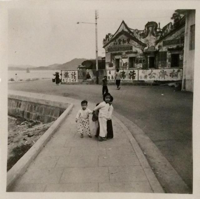
Greetings. Hope discussions will lead to the answer: 1. This appears to be the only photo dated May 11, 1957, two months into your new assignment. 2. There were a few photos taken on May 4 which might help trace the progression. 3. Fairly new shore protection, side walk and road indicate this was recent reclamation to help preserve these old buildings, perhaps for future development. Was this place near the site of your work travel? 4. Calm water (?) and distant islands suggest this is bay area, south side of HK island or north of Shatin as far north as the border. 5. Not too far from your Sham Shui Po address? Regards, Peter
Phil, impressive! I played with Google photos at random shores and gave up. This places the camera somewhere (at or near) the Tin Hau Temple which could be by the water at that time. Several views from the current Sai Kung Promenade show the same ridge line but not quite having the same bearing as in this photo. Regards, Peter
Addendum: Given the near-90-degree turn of the roadway in the photo, this could be the south-eastern tip of Man Nin Street where current Google photo's ridge line matches quite well. It seems to me that the locations of some photo spheres are questionable. The shore line in the 1952 map - https://gwulo.com/jubilee-buildings?a=1#15/22.3769/114.2713/Map_by_ESRI… appears to support this estimate.
I believe the Tin Hau Temple in Sai Kung market had been refurbished\rebuilt and extended a few times over the decades. This may indeed be the old temple at the time. But it seems strange to see so many advertisements being painted on its walls.
If only we could find some old maps or photos of the same area for comparison.
A note, the modern building on the extreme right showing a window may as well be the Sai Kung Public School next door.
Many thanks moddsey, Tom and Phil. The school building is still there as its corner is visible in the 2009 and 2011 street views off Po Tung Road. Now, the frontage are occupied by a fruit stand and electric-plumbing shop. The temple entrance must be just around the corner. Interest like this keeps me glued to this site. Regards, Peter
Hi -Oldtimer-Philk and Tngan.many thanks to each of you for identifying this photo,after over 60yrs.in my album as unknown can now add a name to it,have number of small photos named -Swimming at Clearwater Bay and Silver Strand- taken in same month (May 57) now know after looking at old maps that these bays are in the same area as Sai Kung.I now think that the other unknown photo uploaded at the same time of buildings (dated 4 May 57) is possibly Fang Ling but will await someone confirming this. Also have a memory of a military camp at Sai Kung. Thanks once again, this site always comes up with the answer -thank you. Bryan Panter.
Hi Bryan, you are very welcome. I am pleased to have had the opportunity to participate in the discussion. The children, their clothing, and the girl caring for her siblings, remind me and readers my generation of our childhood days in Hong Kong. Thank you, and, Regards, Peter
Comments
Photo dated 11 May 1957. ——
Photo dated 11 May 1957. ——-Where are they now??
Unknown area (May 11, 1957)
Greetings. Hope discussions will lead to the answer: 1. This appears to be the only photo dated May 11, 1957, two months into your new assignment. 2. There were a few photos taken on May 4 which might help trace the progression. 3. Fairly new shore protection, side walk and road indicate this was recent reclamation to help preserve these old buildings, perhaps for future development. Was this place near the site of your work travel? 4. Calm water (?) and distant islands suggest this is bay area, south side of HK island or north of Shatin as far north as the border. 5. Not too far from your Sham Shui Po address? Regards, Peter
Sai Kung
The ridge line behind the temple is Sharp Island in Port Shelter, so I guess this was the waterfront in Sai Kung village.
Sai Kung (1957)
Phil, impressive! I played with Google photos at random shores and gave up. This places the camera somewhere (at or near) the Tin Hau Temple which could be by the water at that time. Several views from the current Sai Kung Promenade show the same ridge line but not quite having the same bearing as in this photo. Regards, Peter
Addendum: Given the near-90-degree turn of the roadway in the photo, this could be the south-eastern tip of Man Nin Street where current Google photo's ridge line matches quite well. It seems to me that the locations of some photo spheres are questionable. The shore line in the 1952 map - https://gwulo.com/jubilee-buildings?a=1#15/22.3769/114.2713/Map_by_ESRI… appears to support this estimate.
Re; Sai Kung 1957
Hi There,
I believe the Tin Hau Temple in Sai Kung market had been refurbished\rebuilt and extended a few times over the decades. This may indeed be the old temple at the time. But it seems strange to see so many advertisements being painted on its walls.
If only we could find some old maps or photos of the same area for comparison.
A note, the modern building on the extreme right showing a window may as well be the Sai Kung Public School next door.
Thanks & Best Regards,
T
Sai Kung temple car park
I think Thomas it right about the school building, this would make the road in the original photo now part of the adjacent temple car park.
Sai Kung temple car park
Many thanks moddsey, Tom and Phil. The school building is still there as its corner is visible in the 2009 and 2011 street views off Po Tung Road. Now, the frontage are occupied by a fruit stand and electric-plumbing shop. The temple entrance must be just around the corner. Interest like this keeps me glued to this site. Regards, Peter
Help-unknown area.
Hi -Oldtimer-Philk and Tngan.many thanks to each of you for identifying this photo,after over 60yrs.in my album as unknown can now add a name to it,have number of small photos named -Swimming at Clearwater Bay and Silver Strand- taken in same month (May 57) now know after looking at old maps that these bays are in the same area as Sai Kung.I now think that the other unknown photo uploaded at the same time of buildings (dated 4 May 57) is possibly Fang Ling but will await someone confirming this. Also have a memory of a military camp at Sai Kung. Thanks once again, this site always comes up with the answer -thank you. Bryan Panter.
Sai Kung (1957)
Hi Bryan, you are very welcome. I am pleased to have had the opportunity to participate in the discussion. The children, their clothing, and the girl caring for her siblings, remind me and readers my generation of our childhood days in Hong Kong. Thank you, and, Regards, Peter
re: Sai Kung (1957)
Thanks to Bryan for sharing this photo, and to everyone who worked out the location.
If you look at this spot on a 1952 map, the bend in the road and the shallow bay are clear to see:
https://gwulo.com/node/42275#16/22.3810/114.2708/Map_by_ESRI-1952_All-M…
Tin Hau Temple
There is a photo from 1958 that shows the Tin Hau Temple and the Sai Kung Public School (as Thomas has proposed).
The photo was taken by someone from the Luk Yuk Theological Seminary which is close-by.
P.S. Interesting coincidence: two photos taken independantly at almost the same time in a more or less abroad area.
Anti-helminth wonder drug
The main product of the advertiser 何濟公 may be as effective as IVERMECTIN, the political drug of choice for some people nowadays.