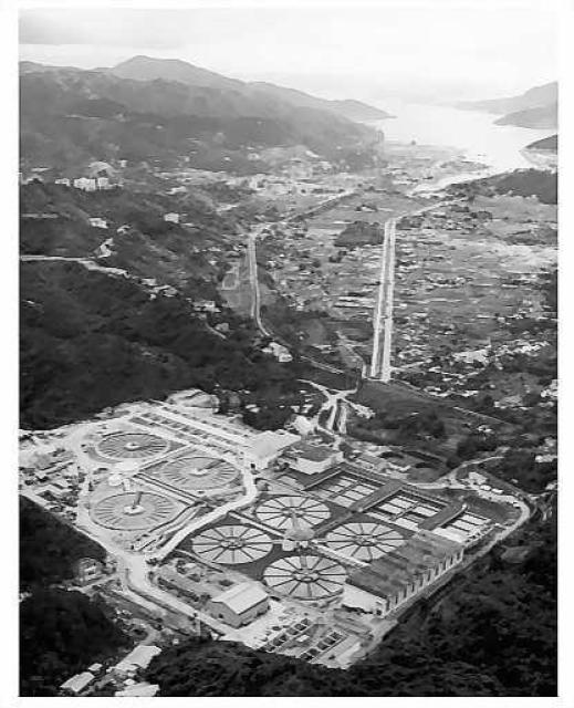
View of Shatin 1973. The Shatin Water Treatment Works, shown in foreground, was built on the hillside in 1964 - http://www.wsd.gov.hk/filemanager/en/share/pdf/ShaTinTW-e.pdf
According to the government web site, since 1983, its output is 1,227,000 cubic metres per day. This capacity amounts to a constant flow of about 14 cubic metres per second, which is a fairly good flow in a stream. While it can intercept runoff from surrounding hills, I wonder if it is supplemented by water diversion from Mainland.
Photo source: uwants.com - post #1483 by user 4rex - http://www.uwants.com/viewthread.php?tid=14833421&page=99#pid210227981
What drew my initial attention in the photo is the nullah. Just a bit beyond these water works is the train track that is very close to the north portal of the tunnel. And beyond the track is the start of the above-ground nullah. There, hikers like myself who just descended from Lion Rock and Amah Rock had the choice of using the dirt path on the left for Shatin. There was a little hut at the beginning of the path but I never saw any sentry or guardsman, perhaps at night only? Or one can walk on the right side of the nullah to the tourist and restaurant area, and from there cross the nullah back to the Shatin station.
The nullah is no longer there now, but memories of it stay strong with me. Those good and free days! Regards, Peter
Comments
Che Kung Miu Rd
Che Kung Miu Rd seems to follow the old nullah quite well, so it’s possible it might still be around, just covered by the road?
Shatin Nullah
Thanks Phil for your feedback. Yes, I agree it is still around and covered by the road, because they still have to take care of the runoff from the hills. The starting point of Chi Kung Miu Road is about the same site where the nullah began. From there, the nullah ran straight towards the sea except for a sharp bend further downstream, and a bit diverging away from the train track. The road, at this point, when looking at Google aerial photos, aims towards the train station.
Perhaps the lower part of the current Shing Mun River follows the same route as the nullah, but I cannot be sure when looking at aerial photos. We know well, Hong Kong tends to move mountains and rivers, possibly this nullah, to develop the land. Regards, Peter
The nullah outlfow into the
The nullah outlfow into the Shing Mun river can be seen on Google Maps, just above the MTR tracks
Shatin Nullah
Thanks Herostratus for the photo, which also points out my spelling mistake of the road. Regards, Peter
P.S. I have created a place page with two photos uploaded. The colour map may give a good indication of how the present Shing Mun River relates to the original nullah in terms of location.
Point of interest - A few ground photos I looked at show high water marks along the Shing Mun River. This, I believe, are tidal effects that extend the entire length of the river. Shing Mun River is on the route that once was part of the sea.
I am lucky to find a current view of Amah Rock from Shatin. Please confirm if the drone shot from just upstream of Lion Rock Tunnel Road is indeed the case, between two beautiful high rises. Given other photo markers are nearby, this is the first marker upstream of the bridge, over water and near the north bank and Heritage Museum.