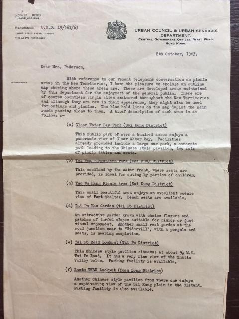
Both Taipo Road lookout and Tai Po Kau garden are still around. The lookout is just a layby with a pavilion, but the garden is better known by the name Chung Tsai Yuen (松仔園)
I was in the Nature Reserve yesterday and came across a nice plot of abandoned land with solid housing a little bit further southwest up the stream. Might this be the "Widervill" spoken of?
I think I might have mis-identified Tai Po Kau Garden as Chung Tsai Yuen? I looked at the 1963 photo (on HKMapViewer) and I think the Tai Po Kau Garden referred to (with slopes etc) is the one still there on the north side of Tai Po Road (about 150 metres up from Chung Tsai Yuen) now identified as Tai Po Kau Park. The 1963 image shows some terraced landscaping that fits the description.
So, if Widervill is the property you are talking about, then perhaps the second garden the paper talks about Being developed is in fact Chung Tsai Yuen? I know it was a beauty spot before hand but had it been landscaped initially? The same photo mentioned above shows it to be fairly plain with parking spaces and not much else.
Comments
Taipo Road
Both Taipo Road lookout and Tai Po Kau garden are still around. The lookout is just a layby with a pavilion, but the garden is better known by the name Chung Tsai Yuen (松仔園)
Widervill
I was in the Nature Reserve yesterday and came across a nice plot of abandoned land with solid housing a little bit further southwest up the stream. Might this be the "Widervill" spoken of?
Tai Po Kau garden
I think I might have mis-identified Tai Po Kau Garden as Chung Tsai Yuen? I looked at the 1963 photo (on HKMapViewer) and I think the Tai Po Kau Garden referred to (with slopes etc) is the one still there on the north side of Tai Po Road (about 150 metres up from Chung Tsai Yuen) now identified as Tai Po Kau Park. The 1963 image shows some terraced landscaping that fits the description.
So, if Widervill is the property you are talking about, then perhaps the second garden the paper talks about Being developed is in fact Chung Tsai Yuen? I know it was a beauty spot before hand but had it been landscaped initially? The same photo mentioned above shows it to be fairly plain with parking spaces and not much else.